 Portuguese
  English
  Spanish
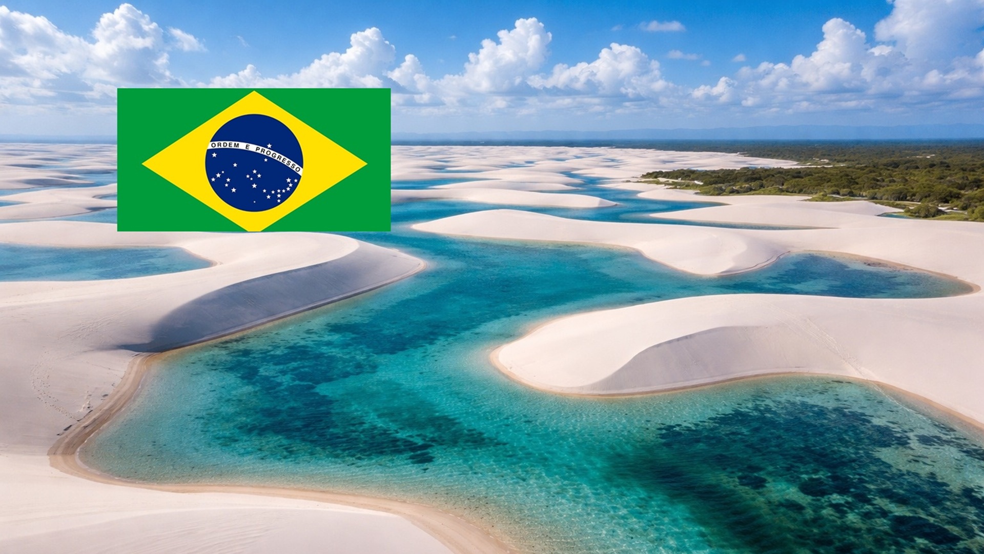


On the Coast of Maranhão, the Lençóis Maranhenses National Park Combines Dunes That Migrate Tens of Meters per Year, Temporary Lagoons Fed by High Rainfall, and an Uncommon Meeting of Biomes, Forming a Dynamic Ecosystem That Challenges Desert Concepts
The visual impact of Lençóis Maranhenses is often immediate. From the top of the first dune, visitors stop in silence before reacting. The landscape, marked by white sand and freshwater lagoons, surprises even those who have seen images of the place. The feeling often reported is one of being on another planet.
This initial astonishment is not exclusive to tourists. Locals report that the first contact with the dune field, even in childhood, also causes shock.
The scene may seem arid, but it hides a complex environmental functioning that challenges simple classifications and reinforces the park’s uniqueness.
-
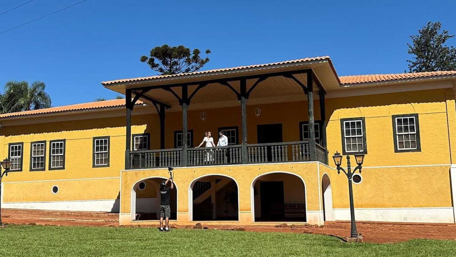
A Brazilian millionaire couple restores a farm over 150 years old in the interior of São Paulo and transforms the historic property with Portuguese tiles, antique furniture, and new spaces into a refuge that blends tradition, comfort, and sophistication.
-
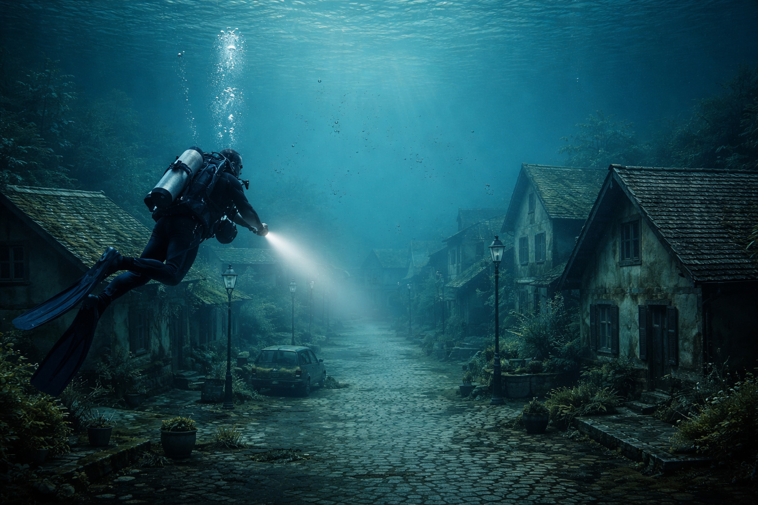
Submerged city in a lake in Minas reveals intact streets, preserved vehicles, and houses after more than 60 years, impressing divers.
-
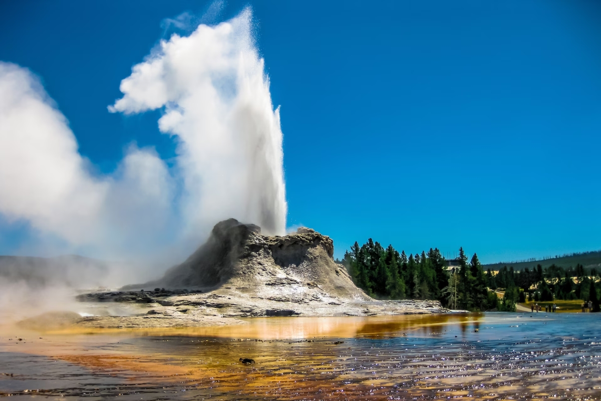
Yellowstone has started to rise again in an area of the caldera, and the movement rekindles fears surrounding the U.S. supervolcano, as scientists monitor the deformation and try to understand what is happening underground.
-
Woman arrested after receiving $1.2 million due to banking error and not returning the amount.


Where They Are and Why They Are Not a Desert
Lençóis Maranhenses are located on the coast of Maranhão, in northeastern Brazil, and form the largest dune field in South America.
Despite their desert-like appearance, the place is not a desert. The region receives about 1,600 millimeters of rain per year, a volume greater than that of cities like London or regions of Scotland.
This characteristic was recently highlighted in a PBS Terra report, a public network from the United States, which presented the Lençóis as an environment often misunderstood.
The high rainfall is precisely what allows for the formation of the seasonal lagoons that define the landscape.
How Dunes Form and Move
The landscape of Lençóis is the result of a continuous process between the sea, wind, and sand. The region exhibits an unusual tide variation, creating very wide beaches during low tide. During this time, the fine sand dries quickly under the sun.
With the action of strong and constant winds, the grains are transported inland, forming extensive chains of dunes. These dunes are not static.
They can move up to 24 m per year, slowly migrating across the territory and permanently altering the relief.
The winds primarily blow in the same direction, which explains the alignment of the dunes and the repetition of the process over thousands of years.
The Emergence of Lagoons Between the Dunes
During the rainy season, usually between the first months of the year, the scene changes radically. Rainwater accumulates between the dunes, forming thousands of temporary lagoons, many large enough for swimming.
One of the most frequently asked questions by visitors is why the water does not quickly infiltrate the sandy soil. The explanation lies beneath the surface. Under the dune field, there is a less permeable rocky layer that prevents complete drainage of the water and allows for its accumulation.
Lagoons that Change Location Every Year
Even with a predictable cycle of flooding and drying, the lagoons never remain in the same spots. As the dunes advance, old depressions are buried, and new areas start to accumulate water in the following rainy season.
This means that no one sees Lençóis Maranhenses the same way twice. The landscape is in constant reconstruction, with lagoons appearing, disappearing, and reappearing in different locations each year.
This dynamic aspect is one of the main points emphasized by scientists studying the park and was highlighted in the PBS Terra production as one of the factors that keeps the place surrounded by mystery, even after millions of years of existence.
A Territory Where Maps Lose Value
The constant movement of sand directly affects human circulation. Trails disappear, vehicle tracks are erased by the wind, and new dunes emerge in a matter of hours. For those living in the region, conventional maps have limited utility.
Local residents orient themselves by the wind, the crests of the dunes, and their memories of the terrain. Even so, getting lost is part of daily life. Accounts of detours and unexpected returns are common, even among people born and raised there.
Communities Shaped by the Advance of Sand
The communities living near Lençóis Maranhenses maintain a historical relationship with the territory. There are families that have been established in the region for several generations, with parents, grandparents, and great-grandparents born in the same place.
Still, permanence is never definitive. The advance of the dunes can force families to move within a few years. Houses can gradually be surrounded or buried by sand, making relocation inevitable.
A Rare Meeting of Biomes
Lençóis Maranhenses are situated in a region where three biomes meet, creating a rare combination that enhances biodiversity. This meeting allows for the existence of unusual environments, such as saline mangrove areas located far from the ocean.
This factor contributes to the presence of species adapted to extreme conditions and, in some cases, exclusive to the park.
Species That Depend on the Lagoon Cycle
Among the endemic animals is the pininga, a freshwater turtle that does not occur anywhere else in the world. It uses the sand of the dunes as shelter, burying itself to reduce metabolism during the dry season.
The fish in the lagoons also follow a similarly unique cycle. Many species have a life cycle of less than a year.
When the lagoons dry up, the fish die, but leave drought-resistant eggs buried in the sediment. With the return of water, life quickly reappears.
Lençóis as a Natural Laboratory
Researchers who have spent long periods living in camps within the park describe Lençóis Maranhenses as an open-air natural laboratory.
The study of amphibians, reptiles, and fish in such short cycles helps to understand how life responds to environmental extremes.
This knowledge is viewed by scientists as potentially relevant in a global context of climate change, where unstable environments may become more common.
Coexistence Between People, Water, and Survival
During the dry season, when lagoons start to disappear, local residents adopt strategies to prolong aquatic life.
Fish can be transferred from lagoons that are drying up to others that still have water, avoiding total losses.
These practices reveal a direct relationship between human communities and the natural cycles of the park, based on observation, adaptation, and survival.
A Place That Leaves a Mark on Those Who Pass Through
Beyond science and geography, Lençóis Maranhenses exert a strong emotional impact. Visitors report feelings of silence, expansiveness, and renewal.
Dragonflies hovering over lagoons, white flowers with submerged roots, and the constant sound of the wind compose a striking sensory scene.
The report from PBS Terra recorded testimonies from people who associate the place with a profound change in perception, describing it as a space capable of transforming the relationship with time, nature, and life itself.
A Mystery in Permanent Motion
With about 2 million years of existence, Lençóis Maranhenses continue to challenge definitive explanations. Everything moves, everything changes, but the system remains.
Dunes advance, lagoons disappear and return, species adapt, and communities reorganize.
This balance between permanence and transformation helps to explain why the park continues to draw scientific interest and international attention.
More than a landscape, Lençóis Maranhenses represent a living process, in constant reconstruction, where nothing is fixed and everything is in motion.

Lugar Pra quem procura A Diferença entre o comum
Tenho uma ilha com 4.290.000m² = 429 hectares a qual está localizada a 15 minutos de lancha ou jet-ski do centro do município de Tutóia na entrada Leste do famoso Lençóis Maranhenses.
Tutóia e nem na divisa do estado do Piauí com a cidade de Parnaíba onde está também famoso Delta do Rio Parnaíba que divide,demarca, o Maranhão e o Piauí.
Meu contato é 98 98137-2927 para quem quiser conhecer natureza e praia limpa de verdade.
Coordenadas Geográficas são:
2°45’43” Latitude Sul
42°16’26” Longitude Oeste
Boa Viagem !
Aproveitem!