 Portuguese
  English
  Spanish


Beneath The Modern Urban Landscape Of Curitiba, A Complex Network Of Geological Faults Defines The Subsoil Of This Important Brazilian Capital. Understand The Geology, The Associated Seismic Risks, And The Challenges For The Urban Planning Of The City.
Curitiba, the capital of the state of Paraná, is widely recognized for its innovative urban planning and the high quality of life it offers. However, a fundamental geological feature that is surprisingly little known by many of its inhabitants is that this Brazilian capital rests upon an intricate and complex fabric of geological faults.
The claim that Curitiba is the only Brazilian capital directly over a geological fault and the general ignorance about this subject prompts a deeper analysis. Discover the geological reality beneath the feet of Curitibans, exploring its implications for the safety and development of the city.
Sedimentary Basin And Its Complex System Of Geological Faults
Curitiba is located over the Curitiba Sedimentary Basin, a tectonic depression of approximately 3,000 km². This basin was primarily filled with sediments from the Guabirotuba Formation, deposited between 42 and 33 million years ago. The genesis of the basin as a graben (a down-faulted block) was controlled by normal faults predominantly oriented from Northeast to Southwest.
-
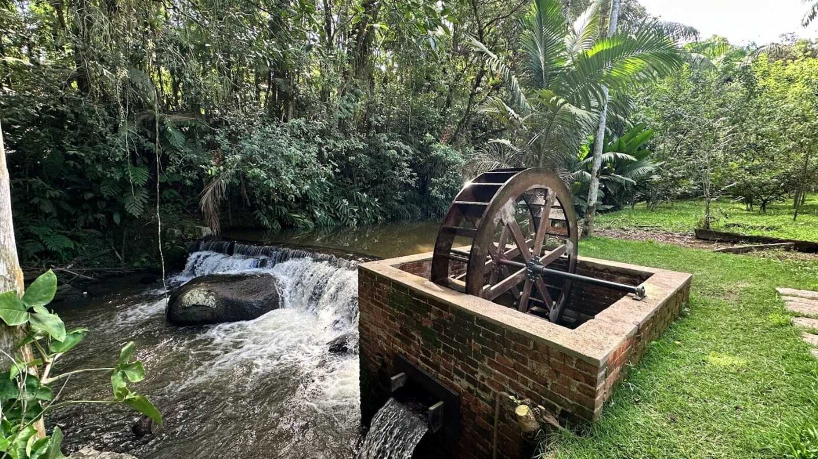
While restoring a historic mansion from 1910, a brick structure with an old turbine that generated energy from the Rio do Testo emerged, along with a hidden door and a rare floor concealed under layers of wax.
-
Italian researchers have detected what appears to be a second Sphinx buried under the sands of Egypt, and satellite scans reveal a gigantic underground megastructure hidden beneath the Giza Plateau for over 3,000 years.

-
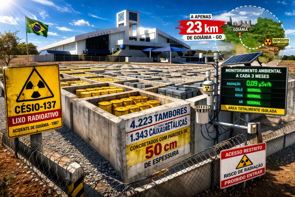
There are 4,223 drums and 1,343 metal boxes concreted with 50-centimeter walls that store the radioactive waste from Cesium-137 in the worst radiological accident in Brazil, just 23 kilometers from Goiânia, with environmental monitoring every three months.
-
Giant Roman treasure found at the bottom of Lake Neuchâtel in Switzerland reveals an advanced trade system, circulation of goods, and armed escort in the Roman Empire about two thousand years ago.


The bedrock is cut by faults and fractures, and subsequent tectonic events also caused new faulting or reactivated pre-existing faults that directly affect the sediments beneath the city, such as the Barigüi River Fault. Additionally, the important Cubatão-Lancinha Fault System crosses the region.
Is Curitiba A Unique Case? Comparing The Geological Situation With Other Brazilian Capitals
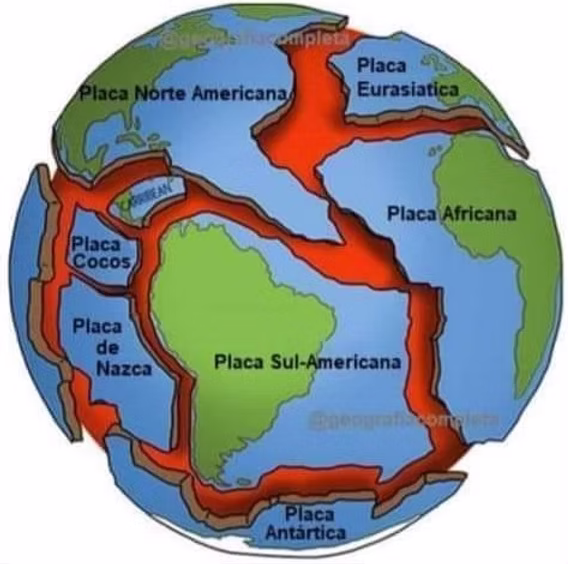
The claim that Curitiba is the “only” Brazilian capital directly over a geological fault must be analyzed with caution. Brazil, although situated in the interior of a tectonic plate, has several active intraplate faults. Regions like the Northeast, with the Samambaia Fault near Natal (RN), have a history of seismicity. Other capitals are also located in sedimentary basins or near large fault systems.
Curitiba’s distinction may lie more in the level of detail of recent geological studies on its urban basin and the dissemination of these findings than in an absolute geological exclusivity compared to another Brazilian capital.
The Ground That Can Shake: The History Of Seismicity And The Seismic Risks For Curitiba
The Curitiba region has recorded seismic activity. A notable event was a tremor of magnitude 4.5 on the Richter scale, with an epicenter possibly between São José dos Pinhais and Mandirituba. Additionally, there was induced seismicity from the Capivari-Cachoeira Hydroelectric Plant (1971-1979) northeast of the city.
According to the ABNT NBR 15421:2006 standard, Curitiba is classified in Zone 1, characterized by low to moderate seismic hazard. Although not high, this risk is not negligible and needs to be considered in urban planning and building design in this Brazilian capital.
Seismic Monitoring And The Resilience Of The Brazilian Capital Of Paraná

Seismic monitoring in Brazil is conducted by networks such as the Brazilian Seismographic Network (RSBR) and the Sismology Center of USP. However, for an accurate assessment of the risk in Curitiba, a greater density of local seismic stations and seismic microzonation studies, which analyze how different types of soil can amplify seismic waves, would be ideal.
An apparent gap exists in the municipal urban legislation of Curitiba (Master Plan and Building Code). Based on the provided documents, no explicit mentions of seismic risk or the obligation to follow NBR 15421 were found, representing a disconnection between technical knowledge and local public policies.
If any reader has images of Curitiba, historical photos of the capital of Brazil, and/or constructive comments, feel free to share them in the comments to collaborate.


África também- li, recentemente que estaria dividindo- se face à uma falha geológica
Excelente artigo, Bruno Teles. Sou testemunha de um tremor ocorrido em 2017. Moro no Cabral e o início da madrugada ouvi um estrondo diferente; não era foguete, não era tiro; era u.a explosão seca. No dia seguinte, uma segunda feira, li que havia ocorrido um terremoto com epicentro em Rio Branco do Sul que se estendeu até São Jerônimo da Serra.
Pela reportagem, não perigo iminente para minha cidadezinha que adotei de coração, sou de Niterói RJ e a qualidade de vida de ambas são semelhantes.