 Portuguese
  English
  Spanish
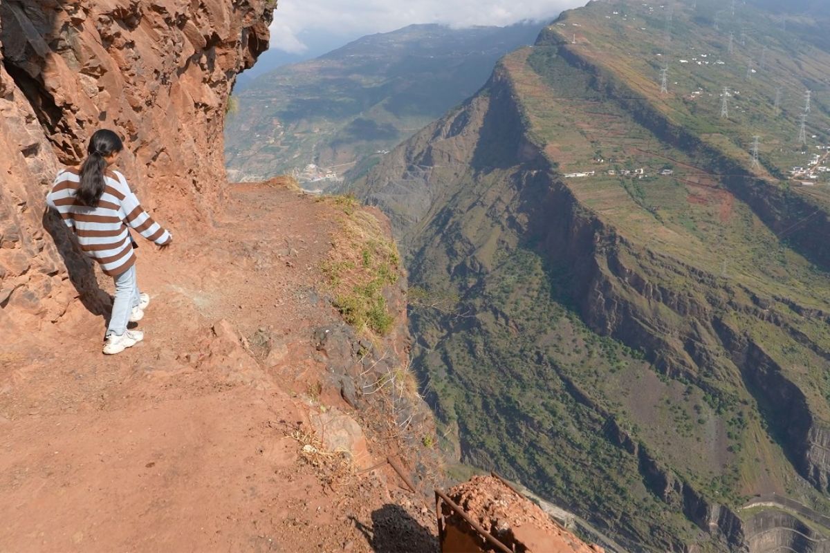
The Yunnan Cliff Road is a historic trail manually carved by residents over a nearly one-thousand-meter gorge, a route that reveals the Baihetan Dam in total perspective, connects villages, served for decades for local transportation, and today safely exposes the rare intersection between popular engineering and megainfrastructure.
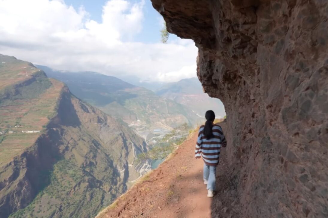
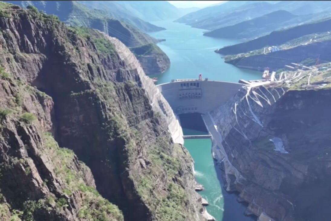
The Yunnan Cliff Road gained fame for combining vertigo and context: it is a path cut into the rock, in sections so narrow that only one person passes sideways, suspended on cliffs that overlook the Jinsha River valley, a tributary of the Yangtze. Along the route, the view opens up to the Baihetan Hydroelectric Power Station, considered the second largest in the world and a symbol of a challenging energy corridor.
More than just a viewpoint, the path is a living piece of local culture. It was opened with hammers by residents, without explosives, between 1992 and 1993, to shorten the trip to the market and link Dazhai communities to the Baihetan construction site. Even after the opening of a lower road, elderly people who get motion sickness in vehicles and sheep herders continue using the route, preserving its original social function.
Origin, Function, and Who Uses the Route Today
The project was born out of necessity. Before the Yunnan Cliff Road, crossing the area required a full day journey over steep slopes.
-
These living root bridges and ladders are over 700 years old and help indigenous people survive in one of the rainiest regions in the world.

-
From sertanejo star to international investor: Ana Castela invests millions in a mansion in the USA, creates a themed accommodation in Orlando, and shows that the “boiadeira” also wants to grow away from the stage.

-
The 10 most stunning motorhomes in the world: a $3 million trailer with a rooftop nightclub and garage for a Ferrari, “palaces on wheels” with Italian marble, private cinema, and five-star hotel luxury for billionaires.

-
Trump wanted to spend $400 million on the White House, but the courts prohibited the million-dollar construction.


With the alignment on the cliff, the path shortened access from the village to the commercial street, enabling shopping, services, and circulation of products.
Today, with a conventional road at the base of the valley, traffic has decreased.
Still, older residents and shepherds maintain daily usage.
It is a faithful portrait of community infrastructure: a thin line on the map that supports local life, even when large projects seem to dominate the landscape.
Route, Risks, and Handcrafted Engineering
The most famous stretch runs along a nearly vertical wall, with points so narrow that visitors must press against the inner wall.
On one side, rock in “blade”; on the other, a void that drops hundreds of meters. There are reports of occasional landslides, fractured blocks, and loose gravel.
Monkeys that roam the cliff can dislodge rocks, which raises the risk below the fall line.
The Yunnan Cliff Road totals about 7 km, including a hand-carved tunnel approximately 400 to 500 meters long, damp, narrow, and dripping.
At some points, the marks of the hammer are visible on the rock, a material record of the human effort that replaced machines and explosives.
How Much, Where, and Why the Path Impresses
Access is free on the traditional stretch, but the “how much” matters in the surroundings: the experience is often combined with paid tours in the area, such as cable cars and park entries, when the goal is to “frame” Baihetan from different angles.
Where? In the county of Qiaojia, city of Zhaotong, Yunnan Province, on slopes dominating the Jinsha valley.
Why is it impressive? Because, step by step, the scenery reveals Baihetan in its entirety.
At one point, a marker of 1,314 meters in altitude helps calibrate the sense of scale.
Each curve delivers a new reference, from the slope to the spillway, while the river sketches the design of the work in the canyon floor.
Baihetan in Technical Perspective
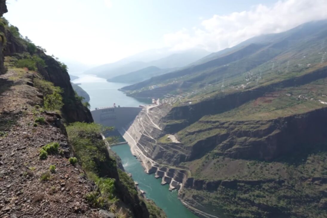
The natural viewpoint of the Yunnan Cliff Road showcases the grandeur of Baihetan.
The complex was planned for decades and took about 12 years to construct.
The setup integrates energy generation, flood control, and sediment retention.
The figures circulated locally help gauge the impact: arch dam about 289 meters high and a daily production cited, in promotional materials, as able to supply the annual consumption of 500,000 people.
The contrast between the megaproject and the minimal pathway highlights a timeline where state infrastructure and popular engineering meet on the same horizon.
Safety and Visitor Conduct
The path is not recommended for those afraid of heights.
Even for experienced climbers, the risk is real: stretches without guardrails, fractured slabs, loose gravel, and the possibility of falling rocks.
Avoid stopping on exposed edges, maintain three points of contact when crossing narrow gaps, do not walk under sections with monkeys, and prioritize the inner side of the trail.
Being a community-use path, priority is given to residents in transit.
Photographs and videos must respect pathways and not block the trail.
Flip-flops and smooth-soled shoes are inadequate; grip and stability are indispensable.
Bring water, a flashlight for the tunnel, and protect your phone in damp sections.
Local Memory and Immaterial Legacy
The Yunnan Cliff Road holds affective markers: engravings in the rock, trees of devotion, and accounts from those who opened it by hand.
The community remembers accidents during its opening and improvised guardrails after falls, indicating informal governance over a common asset.
This heritage, made of repeated gestures and well-trodden paths, cannot be captured in plaques. It is preserved in daily use, rituals, and prudence.
It is a road, a viewpoint, and a record at the same time.
The monumental dam below is the backdrop; the protagonist here is the human trace in the stone.
In the interplay between the energy colossus of Baihetan and the brutal delicacy of the Yunnan Cliff Road, the visitor sees what maps often fail to show: official engineering moves mountains, but popular engineering opens the way. It is this sum that sustains the territory.
Would you take on the full crossing of the Yunnan Cliff Road or would you prefer to observe Baihetan from a safer point?


-

-

-

9 pessoas reagiram a isso.