
 Portuguese
  Spanish
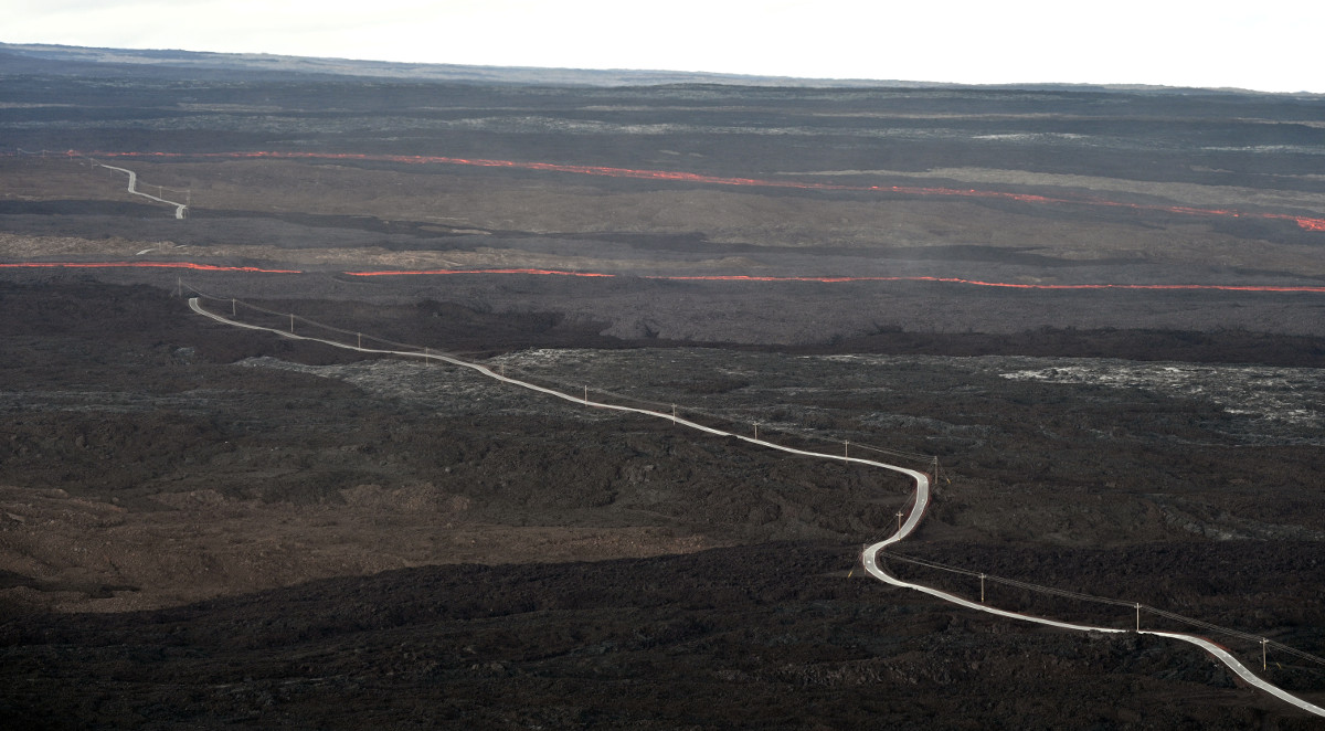
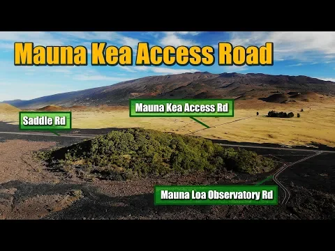
Road in Hawaii Rises Above 3,300 M, Crosses Active Lava Fields of Mauna Loa and Exposes Drivers to One of the Most Extreme Road Environments on the Planet.
In one of the most unstable points on the planet, where the ground literally moves, the Earth’s crust breaks, and rivers of lava have already advanced for kilometers, there is a road that continuously rises to over 3,300 meters in altitude. This route crosses fields of solidified lava, areas of permanent seismic activity, and one of the largest active volcanoes on Earth by volume: Mauna Loa, in the Hawaiian archipelago. The highway that allows this extreme access is the Mauna Loa Access Road, a scientific, technical, and operational road that was not created for ordinary tourism, but to allow for continuous monitoring of a geological colossus that occupies almost 5,300 km² of area, covers about 40% of the Island of Hawaii, and rises up to 4,169 meters above sea level, further continuing to grow from the ocean floor.
This road does not cross just a mountain. It crosses a planetary-scale active geological threat.
When the Road Crosses a Living Volcano in Permanent Activity
Mauna Loa is not an ordinary volcano. It is classified as a shield volcano, characterized by frequent, extensive, and highly fluid eruptions. Unlike explosive volcanoes, it releases basaltic lava that advances rapidly, covering vast areas in a matter of hours.
-
Without a mansion, without high investment, and without a traditional classroom, a teacher living in a 22 m² house taught students to build a 9 m² studio apartment with the equivalent of R$10,000.

-
Largest bridge in São Paulo reaches 75% completion and is expected to strengthen strategic connection in the interior of São Paulo.

-
Without her own home and pressured by rent, a 25-year-old bought a small 15-meter boat, gradually renovated the interior by herself, transformed the interior with paint, new flooring, a larger bathroom, and started living on the canals, paying much less per month.
-
Tired of seeing families sleeping on the street, São Paulo delivered 18 m² furnished microhouses and took 888 people off the streets: Vila Reencontro became the model social housing for the homeless population.


Since the 19th century, Mauna Loa has erupted dozens of times. On several occasions, the Mauna Loa Access Road itself has been cut, partially buried, or isolated by lava flows. Each reconstruction requires new topographic studies, soil analysis, thermal pavement resistance assessment, and seismic risk calculation.
The road crosses areas where the soil temperature just below the surface can remain elevated for years after an eruption. In certain sections, sensors detect abrupt thermal variations beneath the asphalt, requiring constant monitoring.
Ascent Above 3,300 Meters: When the Air, the Body, and the Engine Collapse
As the Mauna Loa Access Road rises, the effects of altitude become clear. Above 3,000 meters, oxygen shows a noticeable drop. Technicians, scientists, and drivers report fatigue, reduced reflexes, accelerated breathing, and dizziness.
In vehicles, especially naturally aspirated engines, there is a real loss of power. Fuel combustion becomes less efficient. Braking also suffers due to long descents and continuous inclines.
Furthermore, the temperature can drop sharply. In one day, it is possible to leave a tropical region at 25 °C and reach the top of the road with temperatures close to 0 °C, or even negative in the Hawaiian winter.
Fields of Solidified Lava: When the Asphalt Rests on Petrified Rivers
Much of the road’s route rests on fields of solidified lava, some formed only a few decades ago. They are black basalt plates, extremely porous, that accumulate heat during the day and release it at night, creating unstable microclimates.
In certain areas, the asphalt has been laid directly over ancient lava flow channels. This creates one of the world’s most extreme scenarios for road engineering: the pavement rests on ground that was once liquid at over 1,100 °C.
The presence of these fields requires heightened attention. Traction varies drastically with temperature. Tire wear is accelerated. And any crack in the ground can indicate tectonic movement.
Constant Seismic Activity Turns Every Shift into a Monitored Operation
Mauna Loa is located over one of the most active volcanic systems on the planet. Small earthquakes are practically daily in the region. Some are imperceptible. Others are strong enough to displace rocks, crack the ground, and affect structures.

For this reason, the road is equipped with geological monitoring points, seismic stations, and ground deformation sensors. During periods of increased magmatic activity, access is restricted or completely blocked.
This is not a road open by chance. Each day of operation depends on prior geological analysis.
A Highway Created to Serve Science, Not Conventional Tourism
The Mauna Loa Access Road was primarily designed to provide access to scientific observatories, meteorological stations, volcanic monitoring bases, and equipment related to the study of the atmosphere, solar radiation, and the magma itself.
Various international institutions use this route to maintain equipment at high altitudes, where the air is cleaner, urban interference is minimal, and atmospheric data has global accuracy.
The road also provides indirect access to astronomical observatories used for solar radar research, cosmic particles, and high mountain climatology.
When the Lava Advances, the Road Becomes Disposable
Unlike traditional highways, the Mauna Loa Access Road is considered temporary infrastructure from a geological perspective. In any new eruptive episode, part of the route may simply cease to exist.
Recent lava flows have already buried kilometers of roads in Hawaii in past eruptions. In some cases, the asphalt disappears under dozens of meters of molten rock. There is no removal, there is no recovery: the road is abandoned, and a new route needs to be planned.
This is one of the rare cases in the world where a road is built already knowing that it can be erased from the map at any moment.
The Tourist Impact of Driving Over an Active Volcano
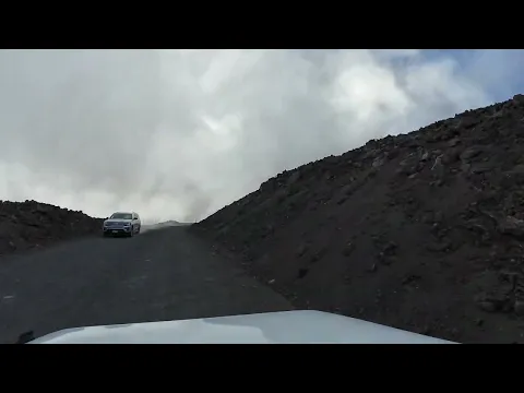
Despite its scientific purpose, the Mauna Loa Access Road has become one of the most sought-after routes by adventurers, photographers, amateur geologists, and tourists seeking extreme experiences.
Driving on a road where signs alert to seismic activity, where the ground is black, uneven, cut by fissures, and surrounded by volcanic cones, creates a sensation that does not exist on any ordinary highway in the world.
There are no dense forests, cities, or villages around. What you see is a lava desert, open sky, strong winds, and a mountain that is still alive.
When the Road Leaves Behind Infrastructure and Becomes a Geological Border
Very few highways in the world occupy such unstable territory as this. The Mauna Loa Access Road does not connect cities. It connects humans directly to the dynamic interior of the planet, where tectonic plates, magma chambers, and internal pressure are in constant motion.
Every meter of this road is a reminder that here, human engineering does not dominate the environment — it merely negotiates with it.
When the Road Reveals How Uncharted the Planet Still Is
The Mauna Loa Access Road proves that, even in the 21st century, there are environments where no technology is definitive.
Where the asphalt is fragile against lava. Where sensors attempt to predict, but not control. Where the road advances only as long as the volcano allows.
It is, at the same time, a victory of engineering and a brutal reminder of the supremacy of geology.


-

-

3 people reacted to this.