 Portuguese
  English
  Spanish
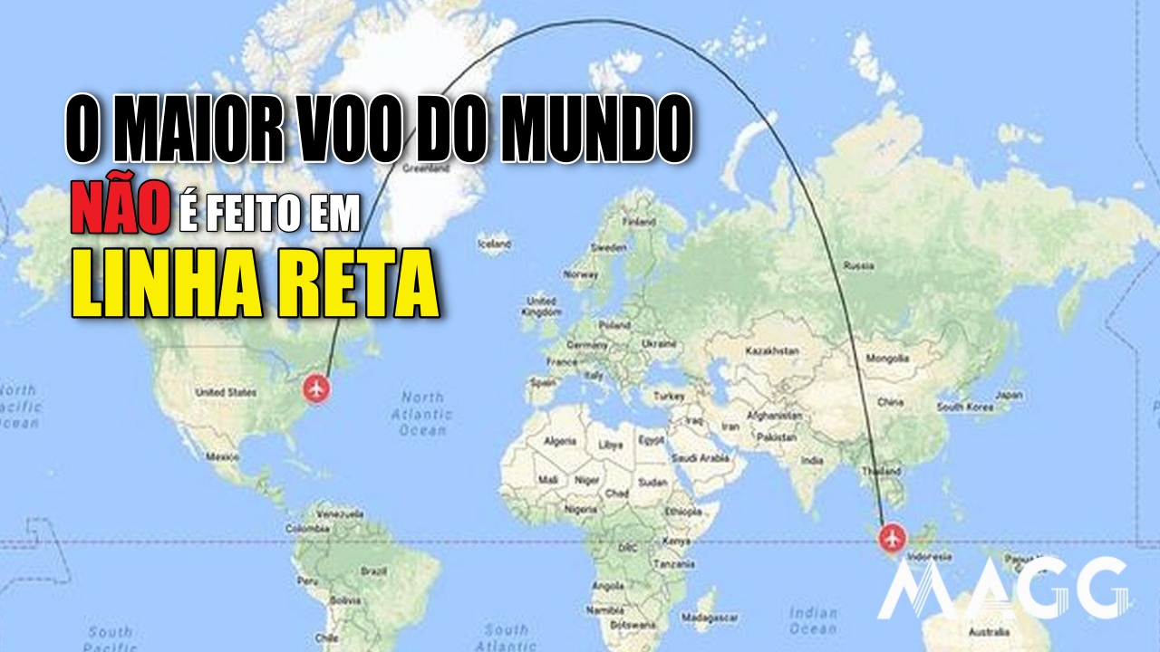
Why Flights Between New York and Singapore Curve Northward, Drawing a Giant Arc on the Map and Challenging Logic
Traveling from one point to another on the planet should be simple: you draw a straight line on the map and that’s it. But aviation insists on challenging visual logic. Anyone observing the flight path of planes connecting New York to Singapore is surprised to see the route “climbing” northward, almost touching the Pole, only to descend again to Asia.
The first impression is one of wasting time and fuel; the reality is exactly the opposite. In aviation, the flight that looks crooked is actually the smartest.
The Map Is Deceptive: The Route Is Curved Because the Earth Is Round
The confusion arises from how the traditional map represents the planet. The Mercator projection, used since the 16th century, flattens entire regions and distorts distances.
-
These living root bridges and ladders are over 700 years old and help indigenous people survive in one of the rainiest regions in the world.

-
From sertanejo star to international investor: Ana Castela invests millions in a mansion in the USA, creates a themed accommodation in Orlando, and shows that the “boiadeira” also wants to grow away from the stage.

-
The 10 most stunning motorhomes in the world: a $3 million trailer with a rooftop nightclub and garage for a Ferrari, “palaces on wheels” with Italian marble, private cinema, and five-star hotel luxury for billionaires.

-
Trump wanted to spend $400 million on the White House, but the courts prohibited the million-dollar construction.


NASA clearly explains that “there is no completely faithful projection of the Earth’s surface,” and this muddles the perception of those who believe that the shortest distance always appears as a straight line on the screen.
When we place the same points on a physical globe and draw a string between them, we discover that the line naturally rises toward the Arctic.
This path has a technical name: great circle route, recognized by IATA as the shortest path between two points on a sphere.
In the specific case of New York–Singapore, the great circle brings the plane quite close to polar latitudes, even though this may seem strange on the map.
The Longest Flight in the World Follows This Principle Every Day
Flight SQ23/SQ24 from Singapore Airlines, considered one of the longest commercial routes in the world, has maintained this logic since it was inaugurated. According to data from FlightRadar24, the line between the two destinations can exceed 15,300 kilometers, varying according to winds, weather, and airspace restrictions.
In 2022, pilot and meteorologist Dan Bubb explained in an interview with CNN that “flying over the North Pole is not an eccentricity: it’s simply a more efficient route when seeking fuel savings and shorter overall flight time.”
This statement does not specifically refer to the NY–Singapore flight but illustrates the principle used in long-distance routes.
This logic has also gained traction after recent geopolitical changes. Since the partial closure of Russian airspace, various airlines have had to adjust paths to avoid Siberia.
Still, they continue to follow the concept of the great circle whenever possible, showing that mathematical efficiency surpasses visual intuition.
Faster, More Economical, and Safer: Three Reasons Why Planes from New York to Singapore Fly North
It’s not just a question of distance. Long routes also depend on:
1. High Altitude Winds:
At altitudes where long-haul planes operate, the jet stream acts like a kind of “aerial conveyor belt.”
The NOAA describes this wind current as a flow that can exceed 200 km/h. Flying within or near it reduces travel time and fuel consumption.
2. Availability of Alternate Airports:
Although it’s a secondary factor, it’s true that northern routes often offer more potential landing spots in emergencies. The ICAO details this in guidelines on transpolar routes.
3. Avoiding Critical Areas Over the Pacific:
The Pacific Ocean is so vast that, in many sections, there is no option for a quick detour. Therefore, it is common for long flights between America and Asia to avoid crossing it through the middle, as noted by the specialized portal Simple Flying.
In the end, what seems like a big detour is just applied physics: by following the curve, the plane uses less fuel, flies faster, and achieves greater operational efficiency.
Flights From New York to Singapore: The Classic Example to Understand All of This Simply
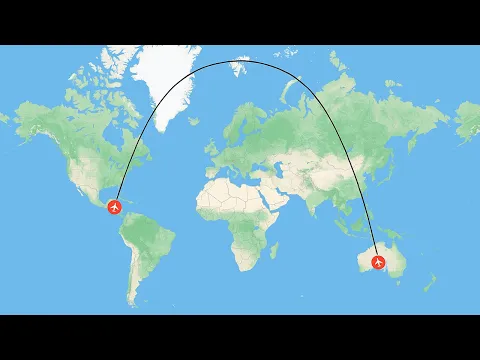
If you want to confirm it at home, just grab a globe and perform the classic experiment cited by various navigation instructors.
First, stretch a string between two points, simulating the “straight path” that appears on the map. Then, repeat with a curve, rising toward the north.
The surprise is immediate: there’s more string left when you make the curved route. This is precisely the behavior that airplanes follow in real life, and which often sparks discussion on social media.
The debate resurfaced after a TikTok content creator published the complete route of the flight between New York and Singapore, questioning why the plane seemed to be “climbing the planet” before descending. In the comments, many people were puzzled, but experts reinforced: the curve is not an error; it’s calculation.
The Final Logic Is Simple: What Seems Longer Is Actually the Shortest Path
When looking at the globe, everything makes sense. The path that appears as an exaggerated arc on the flat screen is, in fact, the most rational choice.
Planes head north because that’s where the savings in time, fuel, and operational safety lies. Commercial aviation does not choose random paths.
Every flown kilometer is planned, reviewed, and optimized, and the New York–Singapore route is one of the best proofs of this.
If you thought the plane diverted out of whim or mystery, now you know: it’s pure spherical mathematics working in favor of efficiency. Want to keep reading about aviation curiosities, strange routes, or phenomena that the map doesn’t show? Leave your comment or share this post.


-

-

-

-

6 pessoas reagiram a isso.