 Portuguese
  English
  Spanish
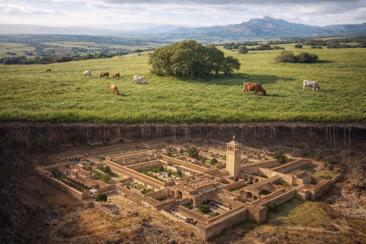
Archeologists from the University of Córdoba used LiDAR data to identify a caliphate city of a thousand years of 120 hectares buried under pastures near Córdoba, Spain, with terraces, rectangular buildings, and a grid that may correspond to the legendary Madinat al Zahira, the lost capital of Almanzor in the Caliphate of Córdoba
A caliphate city of a thousand years may be hidden under pasture hills just twelve kilometers from the famous mosque of Córdoba, Spain. An analysis of LiDAR data conducted by archaeologist Antonio Monterroso Checa from the University of Córdoba revealed over 1,200 meters of terraces, platforms, and rectangular outlines buried under what appears, to the naked eye, to be just an irregular pasture with some oaks. The site is approximately 120 hectares and may correspond to the legendary Madinat al Zahira, the capital that Almanzor built at the height of the Caliphate of Córdoba.
According to the University of Córdoba, the discovery is the result of a technology that shoots millions of laser pulses from the sky and can see what is beneath the vegetation. When the researchers removed trees and crops from the digital model, the outline of a planned city emerged on the screen. Some buildings lean to the southeast, in the direction that Islamic sources associate with religious orientation. For centuries, historians have tried to locate this caliphate city of a thousand years in at least 22 different places. Now, for the first time, there is measurable physical evidence pointing to a specific location.
What LiDAR technology revealed beneath the hills of Córdoba

LiDAR (Light Detection and Ranging) works by shooting millions of laser pulses from aircraft and measuring how they reflect off the ground and vegetation. When specialists digitally remove trees and crops from the model, what remains is the pure outline of the terrain.
-
In 2028, Earth will cross debris left by the Swift-Tuttle comet in 1479, and the world’s most famous meteor shower could turn into a storm of hundreds of shooting stars per hour, a phenomenon that hasn’t occurred since before Columbus arrived in America.

-
China launches the world’s most advanced weather satellite with 6 scientific instruments, a lightning detector, and artificial intelligence capable of predicting storms, tornadoes, and hail with unprecedented accuracy.

-
Scientists drilled 523 meters of ice in Antarctica with water at 75 degrees and found 218 meters of sediments that prove that where there is now half a kilometer of ice, there was an open ocean millions of years ago.

-
The cell phone is present in 99.5% of Brazilian households and has already replaced the alarm clock, the camera, and the GPS; now it is beginning to threaten the last device that resisted: the card reader, which is present in 19 million points of sale in the country.


In the area known as Los Cabezos de las Pendolillas, near the Alcolea neighborhood, the model showed terraces filled with rectangular and square shapes aligned in a regular pattern, something that no one would see walking on the surface.
The first measurements indicate that the complex extends over about 120 hectares, a size comparable to the caliphate city of Medina Azahara, already excavated on the opposite side of Córdoba.
The similarity in scale and layout is one of the reasons the researcher proposes that the site corresponds to the caliphate city of a thousand years that Almanzor built as his own power center. The data used was collected by the National Geographic Institute of Spain for national mapping and was available as public information.
Who was Almanzor and why did his city disappear

Almanzor was the most powerful military leader of the Caliphate of Córdoba in the late 10th century. At the height of his influence, he built Madinat al Zahira as his own capital, an independent power center that rivaled in scale with the palatial city of Medina Azahara, erected decades earlier by Caliph Abd al Rahman III.
The caliphate city of a thousand years served as an administrative and military headquarters during the last decades of the caliphate.
Destruction came just a few decades later. During the civil war that fragmented the Caliphate of Córdoba in the early 11th century, Madinat al Zahira was looted and devastated. The city was so completely destroyed that its exact location was lost, and for centuries scholars debated where it was located.
At least 22 different locations have been proposed over the centuries, all based on medieval texts and isolated finds, never on precise measurements of the terrain.
Why a caliphate city of a thousand years survived beneath a pasture
The region where LiDAR identified the structures is a dehesa, a type of landscape that combines grazing, sparse trees, and low-intensity rural use. Historical records show that .
Historical records show that this area in Spain has been recorded since the 15th century as pasture under the Crown and later as a site for royal stud farms, uses that limited urban growth and prevented modern constructions over the remains of the caliphate city.
This long history of low-intensity use acted as a kind of involuntary protection. While other areas of Córdoba have been urbanized over the centuries, destroying medieval remains, the pasture preserved the caliphate city of a thousand years as a fossil beneath the oaks.
To anyone walking on the hill, it all looks like a common undulating field. But in the digital model generated by LiDAR, the outlines of a planned city appear clearly.
Archaeology without excavation: how LiDAR changes the way to search for lost cities
One of the most notable aspects of this work is what did not happen. No heavy machinery excavated the soil, no trench was opened in pastures, and no tree roots were torn out.
The team read a thousand years of history using data that had already been collected for national mapping and was publicly available. This represents a paradigm shift in the search for archaeological sites.
In practice, any future excavation at this site can be much more targeted and less destructive. Researchers already know where the terraces, walls, and platforms are located and can plan small strategic test trenches instead of opening large areas blindly.
This approach protects the dehesa ecosystem in Spain and allows for the investigation of the caliphate city of a thousand years without destroying the landscape that has preserved it all this time.
What is needed to confirm that this is the Madinat al Zahira of Almanzor
The authors of the study themselves emphasize that the work is a hypothesis, not a definitive verdict. Only systematic field surveys and dating of the materials found can confirm whether the structures beneath Pendolillas truly belong to Almanzor’s ephemeral capital.
The next national LiDAR flights, with even higher resolution, and experimental aerial magnetic surveys may refine the image before any excavation begins.
What makes this hypothesis hard to ignore is the scale and regularity of the detected structures. A caliphate city of a thousand years with 120 hectares in Spain, aligned terraces, recognizable urban patterns, and religious orientation compatible with Islamic sources does not appear by chance in a LiDAR model.
If confirmation comes, it will be the conclusion of a search that has lasted centuries and involved dozens of competing proposals about where Almanzor established his power center.
A lost capital that may have been hidden in plain sight
The possible discovery of a caliphate city of a thousand years under a pasture next to a modern highway is the kind of find that reminds us how history hides in the most unlikely places.
Revealed not by accidental excavations, but by a laser scan from the sky, Almanzor’s Madinat al Zahira may finally have been located after centuries of searching.
Now, the final word belongs to the excavations that will confirm or dismiss what LiDAR has shown.
Did you know that entire cities may be hidden beneath common pastures? Do you think LiDAR will revolutionize archaeology or do we still need shovels on the ground to be sure? Leave your thoughts in the comments and share this article with anyone fascinated by medieval history and technology.


Seja o primeiro a reagir!