 Portuguese
  English
  Spanish
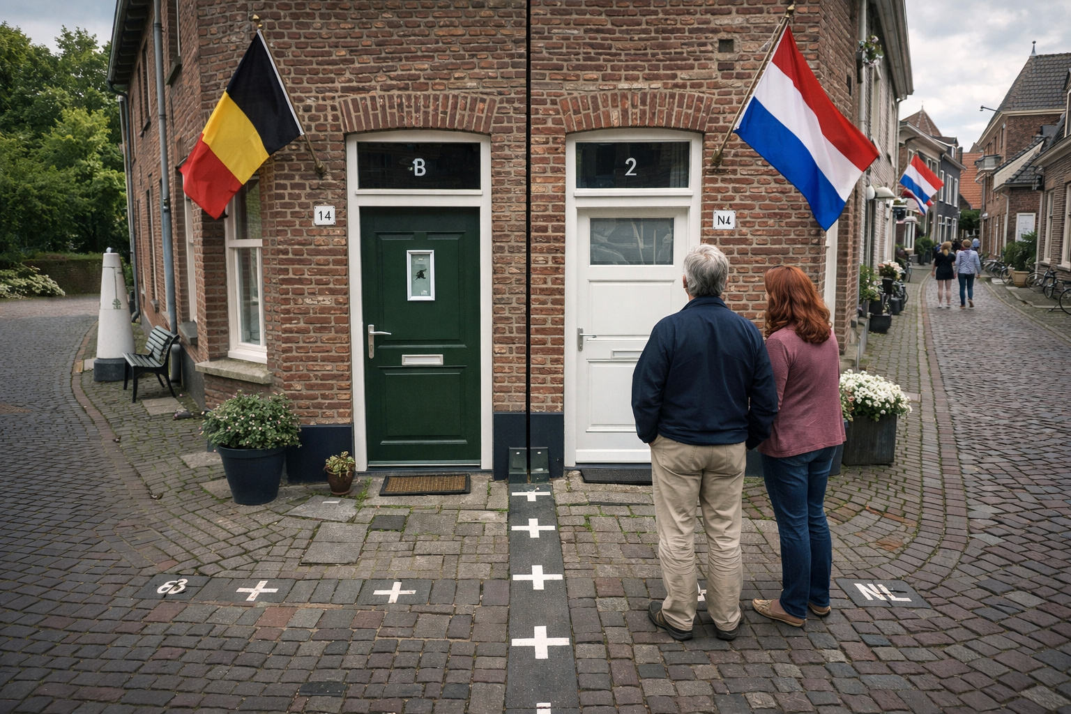
Fragmented border between Belgium and Holland transforms Baarle into a complex territorial mosaic, where historical enclaves create a unique division, a direct result of feudal agreements maintained over the centuries.
In 1995, the governments of Belgium and Holland concluded a process that had been dragging on for centuries: the definitive formalization of the border of the city of Baarle, now considered one of the most complex territorial divisions on the planet. The situation originates from feudal agreements initiated as early as the 12th century, when lands were fragmented among local lords in an extremely irregular manner, creating a territorial mosaic that spanned generations without being reorganized.
The city, in practice, is composed of two distinct administrations: Baarle-Hertog, belonging to Belgium, and Baarle-Nassau, belonging to Holland. The result of this historical division is a territory where small pieces of one country are scattered within the other, forming a configuration that does not follow continuous lines, but rather a true geographical puzzle.
This scenario was only officially defined in the 20th century, even after Belgian independence in 1830, because it was simply not possible to draw a single border line without disregarding already established old agreements.
-
Oropouche virus spreads again in Brazil, silently advancing with an almost invisible mosquito and raising concerns due to its similarity to dengue.

-
Silvio Santos surprised everyone with his generosity: the creator of SBT guaranteed a job, high salary, and eternal benefits to his loyal aide.

-
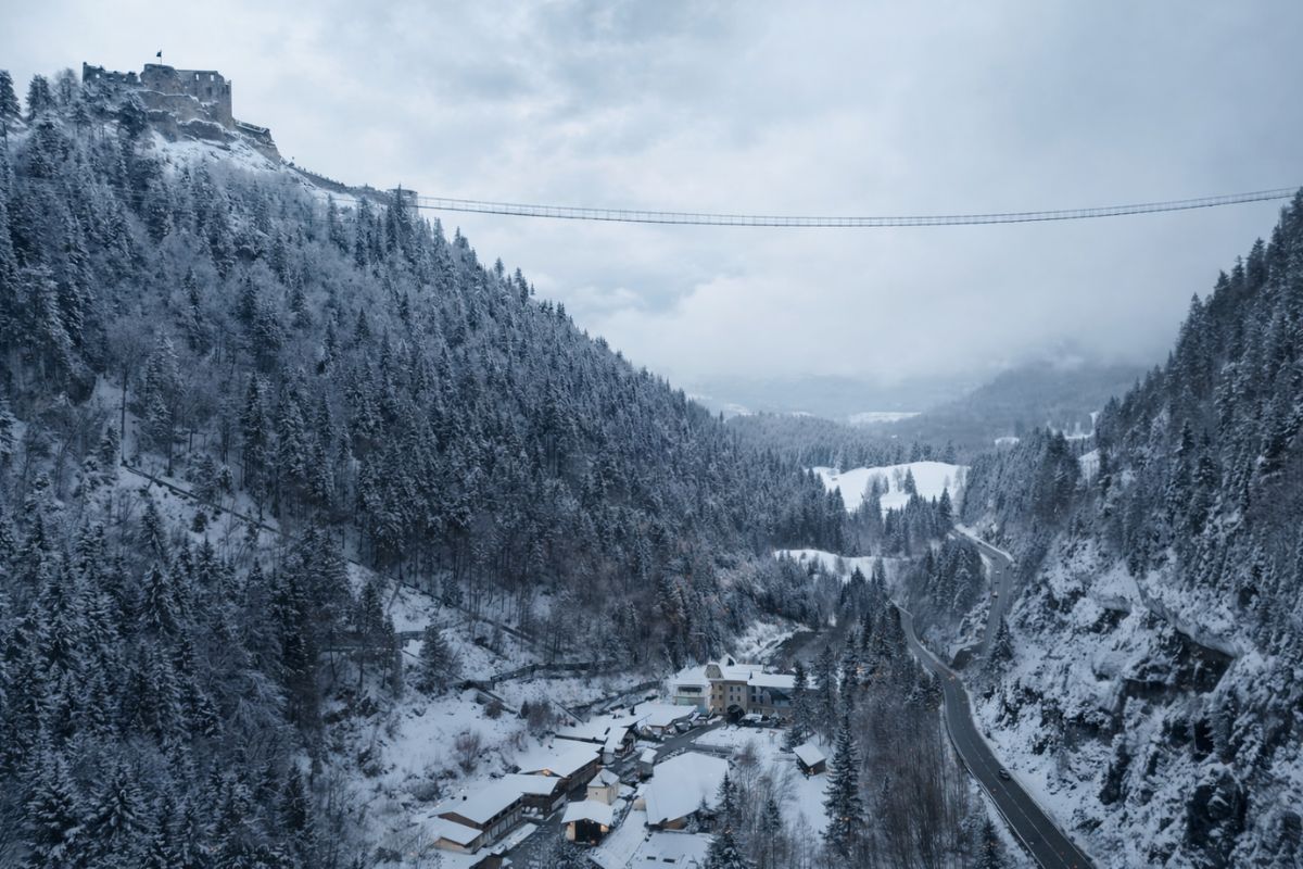
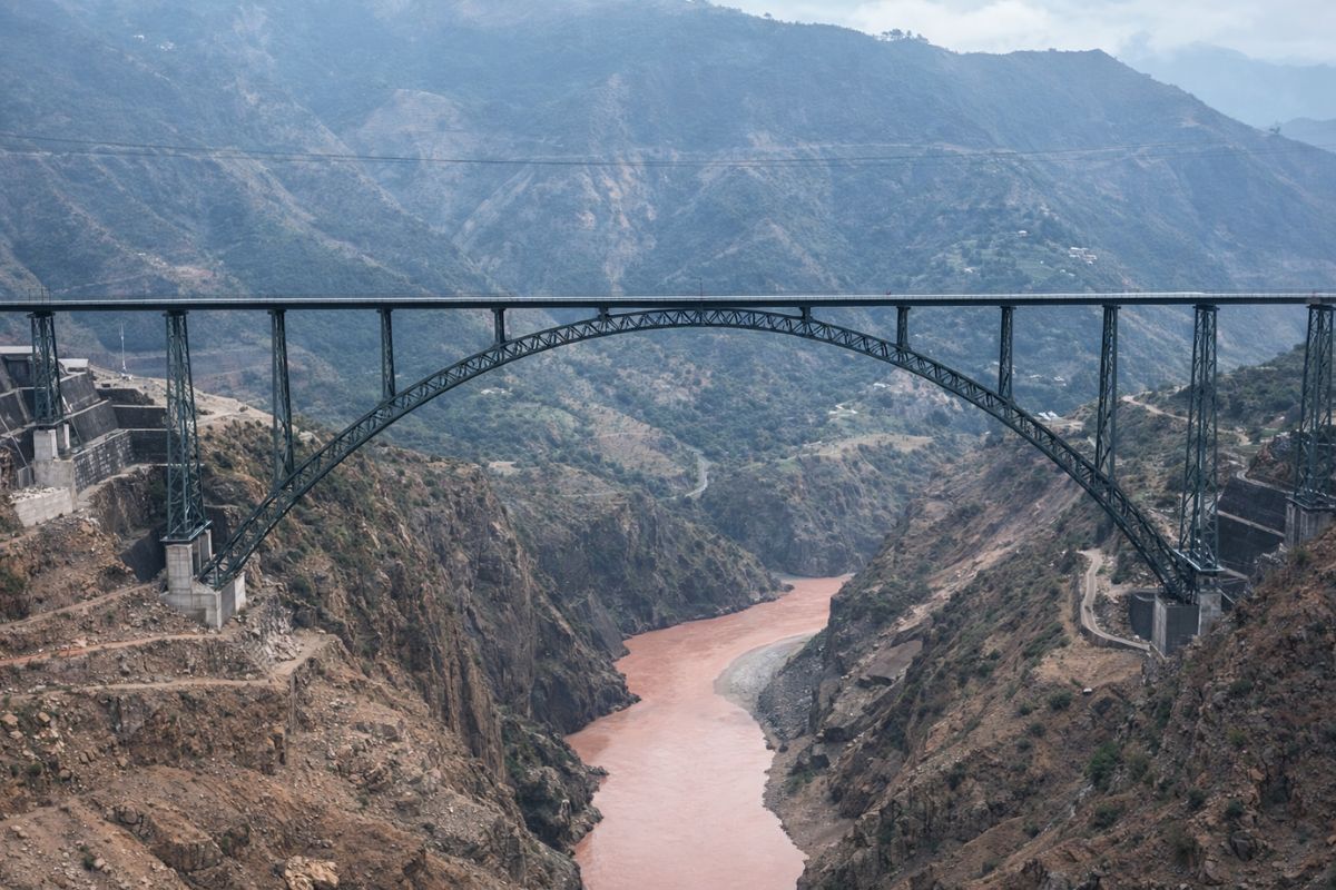
With a height of 406 m and 114 m, the Highline 179 in Tyrol, Austria, challenges fear: crossing the largest Tibetan-style suspension bridge, built in 2014, to the ruins of a castle from 1480 with snow.
-
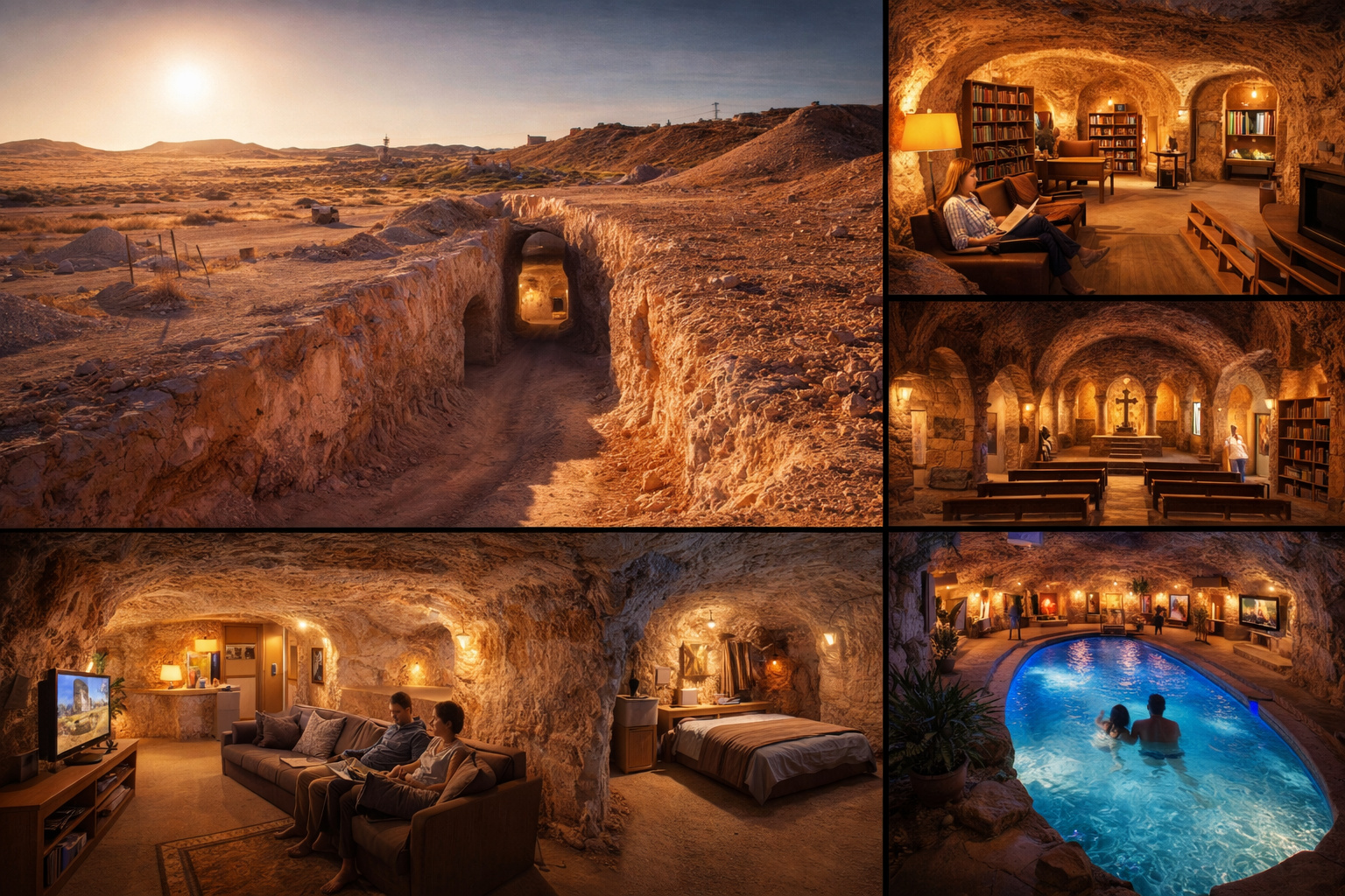
In Australia, an entire city was built underground because the surface temperature exceeds 50°C. In Coober Pedy, most residents live in homes carved out of abandoned opal mines, with churches, bookstores, art galleries, and even underground swimming pools.
City gathers about 30 enclaves scattered between Belgium and Holland in one of the most complex maps in the world
What makes Baarle unique is not just the fact that it is on the border, but the way this border exists. Instead of dividing the countries with a continuous line, the territory houses about 30 interconnected enclaves between Belgium and Holland, many of them with irregular shapes and distributed in an apparently random manner.

In practice, this means that there are pieces of Belgium completely surrounded by Holland and within these Belgian pieces, there are still parts of Holland inserted again.
This phenomenon is known as a system of enclaves and counter-enclaves, something extremely rare in the world. In Baarle, this complexity reaches an unusual level, with dozens of territorial fragments coexisting in the same urban space.
Border does not follow streets, but crosses houses, stores, and even rooms
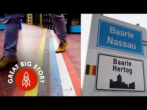
Unlike most border cities, where the division occurs by streets, rivers, or natural barriers, in Baarle the border cuts directly through urban space. It passes through streets, sidewalks, stores, restaurants, and even inside houses.
In some documented cases, a residence can be literally divided between two countries, with one room located in Belgium and another in Holland.
There are situations where a living room is in one country while the kitchen is in another, creating scenarios where residents physically live in two different territories within the same property.
Door rule defines property nationality and can change everything
To resolve this complexity in daily life, a practical rule was created that defines the nationality of properties. The country of a house is determined by the location of the front door. This means that: if the main door is in Belgium, the property is Belgian, if it is in Holland, the property is Dutch.
This rule has real consequences, as it determines which legislation applies, which tax system will be used, and which commercial standards must be followed.
There are cases where owners have even modified the position of the front door precisely to change the legal classification of the property, showing how an architectural detail can have a direct impact on the legislation applied.
Origin of territorial chaos dates back to feudal agreements of the 12th century
The explanation for this unusual division lies in the medieval history of the region. In the 12th century, lands were divided between the Duke of Brabant and the Lord of Breda, in a series of negotiations that did not follow simple geographical criteria.
Instead of dividing large continuous areas, the agreements distributed: specific agricultural plots, already occupied or cultivated parcels, and lands with immediate economic value.
This fragmentation was maintained over the centuries and ended up being incorporated into the treaties that defined the modern borders between Belgium and Holland. The result was an extremely fragmented territory, where the medieval logic has been preserved to this day.
Border was only officially organized after centuries of uncertainty
Even after Belgium’s independence in 1830, the situation in Baarle remained undefined for a long time. Attempts to reorganize the territory were made, but always encountered practical and political difficulties.
Only with later agreements and, mainly, with the complete formalization in 1995, did the border begin to be officially recognized with precision. Before that, there were sections where it was simply not possible to clearly determine where one country ended and the other began.
Marking on the ground shows exactly where each country begins and ends
To avoid confusion, the border in Baarle was physically marked on the ground of the city. Lines, crosses, and symbols clearly indicate where the division between Belgium and Holland is. These markings appear:
- on the streets
- inside establishments
- in front of houses
- and even crossing indoor environments
In many places, it is possible to literally take a step and move from one country to another without realizing it, as there are no physical barriers or checkpoints, especially after European integration and the Schengen agreement.
Differences between laws of the two countries have already affected the functioning of the city
Over time, differences between the legislations of the two countries have generated curious situations. At certain times, distinct commercial rules led merchants to creatively adapt their businesses. A classic example occurred when: bars in Holland had to close earlier than in Belgium.
In some establishments located exactly on the border, customers simply moved to the Belgian side to continue consuming after the allowed time on the Dutch side. This type of situation shows how the territorial division directly influences the daily life of the city.
Houses can have two numbers and even two different addresses
Due to the territorial division, some houses have unique characteristics. There are properties that:
- Have two different numbers;
- Have two official addresses;
- Are registered in two countries simultaneously.
This happens when the building is exactly on the border line, reinforcing the level of complexity of the location.
City has become one of the most known geographical curiosities in Europe
Today, Baarle is considered one of the most extreme examples of territorial division in the world. The place attracts tourists, researchers, and curious individuals interested in understanding how a city functions where the border is not a line, but a mosaic.
The region concentrates a significant number of global enclaves, often cited as one of the most complex borders ever recorded.
European integration reduced conflicts, but did not eliminate the uniqueness of the location
With the creation of the European Union and the free movement agreement, many of the practical difficulties have been reduced. Today, residents move freely between the two countries, without the need for border control. However, the division still exists legally and administratively, maintaining the uniqueness of the city.
The case of Baarle is a clear example of how decisions made centuries ago continue to influence the current territorial organization. The division created by feudal agreements has survived wars, political changes, and economic transformations.
The result is a city where the past remains visible not only in documents but in the daily lives of people.
In light of this, the question arises: living in a place where you can cross countries just by walking inside your house would be an advantage or a complication in daily life? Leave your opinion in the comments.


Seja o primeiro a reagir!