 Portuguese
  English
  Spanish
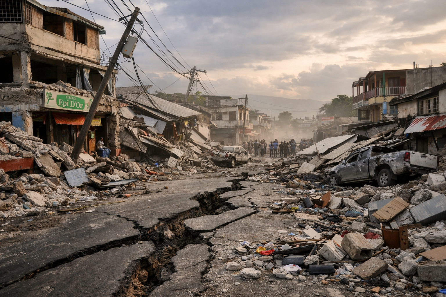
What Scientists Discovered Beneath The Haitian Crust After The Great Earthquakes Of 2010 And 2021 Reveals That The Earth Does Not Stop Moving When The Shaking Ends, Exposing Hidden And Fragile Faults That Alter The Understanding Of Seismic Risk
When it comes to earthquakes in Haiti, the most common image is that of a single geological fault violently breaking, tearing the ground and causing destruction in a matter of seconds. However, new scientific research shows that this view is overly simplified. What really happens beneath the surface is much more complex, silent, and prolonged over time.
The information was released by the website of the scientific journal Geophysical Research Letters, which published a study detailing how, after the major earthquakes of magnitude 7.0 in 2010 and 7.2 in 2021, in southern Haiti, the underground continued to move for weeks. This movement did not occur only on the main fault but involved a network of shallow secondary fractures that slowly slipped after the main shaking ended.
These fractures function almost like “relief valves” of the Earth’s crust. Although discreet, they release some of the accumulated tectonic stress, revealing that the upper crust is less rigid than many traditional seismic models still assume.
-
He started running at 66 years old, broke records at 82, and is now a subject of study for having a metabolic age comparable to that of a 20-year-old, in a case that is intriguing scientists and inspiring the world.

-
Oldest tree on the planet reappears after 130 years of searches: Wattieza, 385 million years old, was 10 meters tall and had no leaves or seeds; Gilboa fossils in New York solved the mystery in 2007.

-
A 48-square-meter house assembled in hours with 4,000 bricks made of recycled plastic that does not absorb moisture, has natural thermal insulation, and costs less than 90,000 reais in a complete kit.

-
Luciano Hang revealed that Havan’s air fleet has already accumulated more than 20,000 landings, 10,000 flight hours, and 6 million kilometers traveled, and he says that without the planes, the company would never have grown so quickly.


Satellites Reveal Hidden Faults That Remain Active After The Shaking

To identify this movement invisible to the naked eye, scientists turned to InSAR technology, an advanced satellite radar method capable of detecting ground displacements of a few centimeters. Data from the European satellites Sentinel-1, related to the 2021 earthquake in the Nippes region, as well as older data from the Japanese satellite ALOS, used to study the 2010 event, were analyzed.
By comparing radar images obtained at different times and angles, researchers observed clear patterns of lateral ground displacement. These patterns are characteristic of strike-slip faults, where two blocks of rock slide horizontally against each other.
In total, 14 secondary structures activated after the 2021 earthquake were identified. Most of them exhibited displacements of only a few centimeters at the surface, but sufficiently consistent to stand out from the natural noise of the data. Some of these faults were located up to 20 kilometers away from the main fault, highlighting that the impact of the earthquake spreads over a much larger area than previously thought.
Interestingly, not all of these faults moved in the same direction. While some slid in the same direction as the long-term tectonic movement between the Caribbean and North American plates, others moved in the opposite direction, countering the regional stress flow. In simple terms, some of these fractures “went backward” for a short period, pushed by the changes in the stress field caused by the main earthquake.
Weak Faults, Friction, And Time As A Decisive Factor
Next, the researchers sought to answer a central question: would this slow movement be merely a temporary elastic response of the damaged rocks, or would it represent actual sliding governed by friction laws and dependent on time?
To do this, they applied a classic “rate and state” friction model, widely used in seismology. The results showed that the slipping of both the main fault — the Enriquillo Plantain Garden Fault — and the secondary faults decreases approximately logarithmically over weeks and months. This behavior is typical of surfaces with “velocity strengthening” friction, which relax sudden changes in stress through slow, progressive sliding.
The calculations also indicate that the determining factor for the direction of movement is not the normal pressure that “pushes” the fault, but rather the shear stress variation induced by the main earthquake. When this stress increases in the regional direction, the secondary fault slips in the expected direction. When it decreases, even an extremely weak fault can be forced to move in the opposite direction.
Based on the short wavelength of the observed deformations, scientists estimate that these secondary faults are confined to the first 1 to 2 kilometers of the Earth’s crust. Below this shallow layer, the main fault remains locked for most of the seismic cycle, accumulating elastic energy that may be released in future major earthquakes.
What This Changes In The Assessment Of Seismic Risk In Haiti
For decades, many seismic risk models have treated the upper crust near tectonic plate boundaries as essentially an elastic block, continuously accumulating tension and releasing it almost exclusively during major earthquakes. The results obtained in Haiti challenge this view.
The data suggest that, at least in the first kilometers of the crust, the behavior is much more malleable and fragmented. Weak secondary faults are constantly ready to slip whenever small stress variations occur, functioning as natural shock absorbers of the tectonic system.
This mechanism helps explain the so-called “shallow slip deficit”, a phenomenon observed in various earthquakes around the world, where the displacement near the surface is less than expected by purely elastic models. Recent global studies indicate that networks of small faults can absorb over 30% of regional tectonic deformation, redistributing the load among multiple structures.
For populations living in seismically active regions, this does not mean that major earthquakes are less dangerous. Haiti’s recent history painfully demonstrates that a single main rupture can still cause structural collapses, disrupt essential services, and lead to human losses in a matter of seconds.
What this research offers is a more realistic understanding of the behavior of the crust between these extreme events. In practical terms, this knowledge can enhance how scientists interpret satellite data, turning slow and silent movements into more accurate estimates of future risk. Additionally, it reinforces the importance of ongoing Earth observation programs, as displacements of a few centimeters in little-known faults may, over the long term, influence building codes and land use policies in highly vulnerable regions.
The study was published on the website of the journal Geophysical Research Letters.
Image credits: UNICEF / NASA / Copernicus.


-

-

4 pessoas reagiram a isso.