 Portuguese
  English
  Spanish
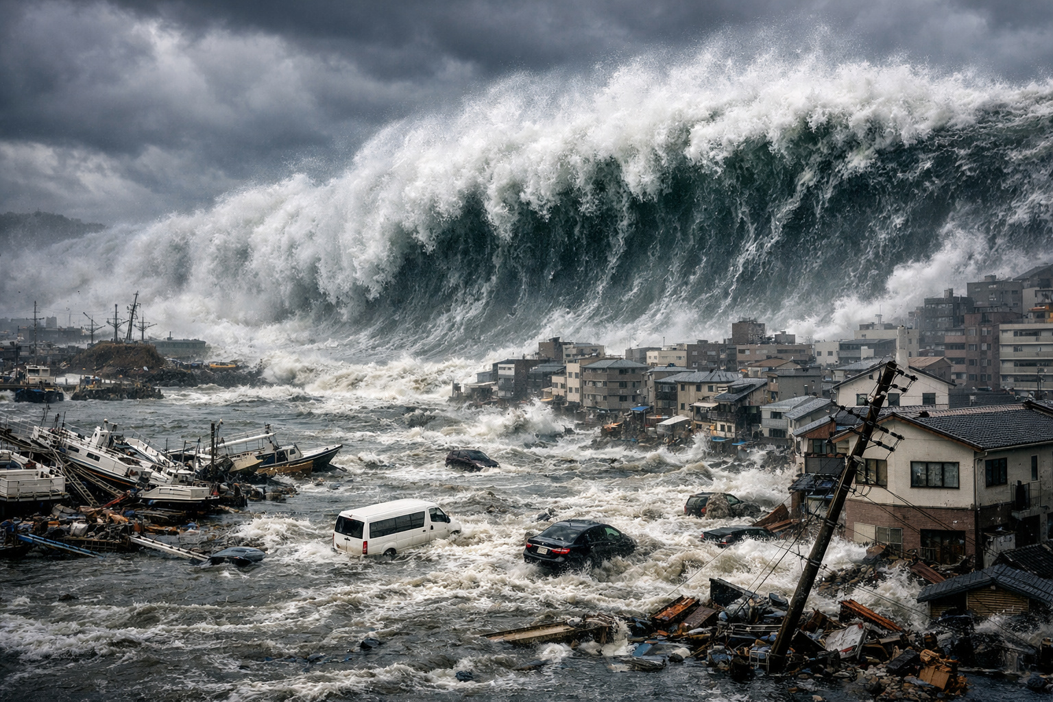
Research Reveals That Geological Fault In Subduction Zone Allowed 9.1 Magnitude Earthquake To Displace Seafloor By Up To 70 Meters Over 500 Kilometers, Intensifying Waves That Devastated 561 Sq Km Of Japanese Territory
The Tohoku earthquake, which occurred in 2011 in eastern Japan, is already considered one of the most devastating seismic events in modern history. However, new scientific evidence suggests that the impact may have been even more severe due to a hidden factor beneath the ocean: a thick layer of extremely slippery clay on the seafloor. This information was disclosed by “Live Science,” based on a study published in the scientific journal Science, which provides new explanations for the magnitude of the disaster.
According to the research, this layer of clay, which can reach up to 98 feet (30 meters) thick on the ocean floor, created a structurally weak point in the geological fault zone. As a result, the 9.1 magnitude earthquake managed to transfer its motion to the seafloor with unusual intensity, favoring the vertical displacement of the oceanic crust.
How Slippery Clay Amplified The Impact Of The 9.1 Magnitude Earthquake
The mechanism behind the tsunami intensification is directly linked to how the seafloor moved. According to researchers, the vertical displacement of the oceanic crust varied between 164 and 230 feet (50 to 70 meters) over approximately 310 miles (500 kilometers). This abrupt push of the seabed against the water column was precisely what generated the giant wave that struck 217 square miles (561 square kilometers) of Japanese territory.
-
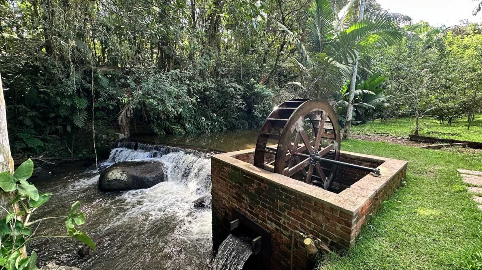
While restoring a historic mansion from 1910, a brick structure with an old turbine that generated energy from the Rio do Testo emerged, along with a hidden door and a rare floor concealed under layers of wax.
-
Italian researchers have detected what appears to be a second Sphinx buried under the sands of Egypt, and satellite scans reveal a gigantic underground megastructure hidden beneath the Giza Plateau for over 3,000 years.

-
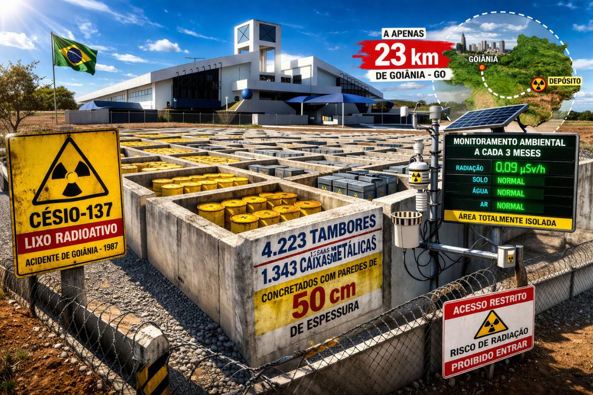
There are 4,223 drums and 1,343 metal boxes concreted with 50-centimeter walls that store the radioactive waste from Cesium-137 in the worst radiological accident in Brazil, just 23 kilometers from Goiânia, with environmental monitoring every three months.
-
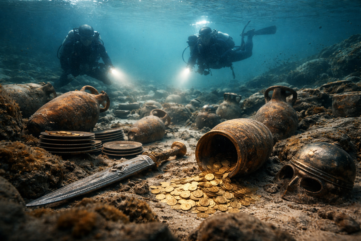
Giant Roman treasure found at the bottom of Lake Neuchâtel in Switzerland reveals an advanced trade system, circulation of goods, and armed escort in the Roman Empire about two thousand years ago.

As explained by Ron Hackney, a geophysicist at the Australian National University and director of the Australian and New Zealand International Scientific Drilling Consortium, clay has low friction, which makes it mechanically weak. “It can slide very easily,” the specialist stated. In other words, this geological composition allowed the accumulated energy to be released in a more concentrated manner.
Additionally, the study indicates that the lateral rupture of the fault was about half of what researchers expected. Consequently, the energy that would normally spread horizontally was channeled into vertical movement. This phenomenon concentrated the displacement of the seafloor in a reduced area, unexpectedly intensifying the tsunami.
Drilling At 7,000 Meters Reveals The Origin Of Geological Fragility
To accurately understand what occurred in 2011, Hackney and his team conducted a scientific mission in 2024 aboard the Chikyu research vessel. During the expedition, researchers drilled down 23,000 feet (7,000 meters) below the ocean surface and an additional 3,300 feet (1,000 meters) beneath the seabed, directly reaching the fault responsible for the earthquake.
From this deep drilling, sediment cores were taken from both the fault and the Pacific Plate. The results revealed that the oceanic plate is covered by a thick layer of viscous clay that has been slowly accumulating for about 130 million years. As the Pacific Plate slides beneath Japan in a subduction zone, this clay is compressed, just like the continental rocks above it.
This process creates a mechanically fragile point, compared by researchers to a puncture in a sheet of paper. In other words, it is an area naturally prone to rupture. When tectonic stress reaches critical levels, the fault breaks more easily, favoring shallow and intense slips.
The study, published in December 2025 in the journal Science under the title “Extreme Plate Boundary Localization Promotes Shallow Earthquake Slip At The Japan Trench,” brings together researchers such as J. D. Kirkpatrick, H. M. Savage, C. Regalla, S. Shreedharan, C. Ross, H. Okuda, U. Nicholson, K. Ujiie, R. Hackney, M. Conin, P. Pei, S. Satolli, J. Zhang, P. Fulton, M. Ikari, S. Kodaira, L. Maeda, N. Okutsu, S. Toczko, and N. Eguchi.

Do Other Regions Of The World Have Similar Risks?
Although the data is robust for Japan, there is still uncertainty about the presence of similar layers in other subduction zones. There are indications that similar formations may exist near Sumatra, Indonesia — the region where the 9.1 magnitude earthquake occurred on December 26, 2004, which also generated a devastating tsunami.
On the other hand, areas like the Kamchatka Peninsula, where large earthquakes are also recorded, still lack detailed studies on the geological materials that feed their fault zones. Therefore, new drilling and analyses will be crucial to understanding the behavior of these regions.
Currently, scientists are increasingly advancing in their ability to predict the magnitude of earthquakes and map the areas where tremors will be felt. Early warning systems can already alert the population seconds or minutes before the tremor arrives. In the case of tsunamis, the response time is even longer.
However, improving the understanding of how the seafloor moves during major earthquakes could represent an even more significant leap in protecting human lives. After all, the more accurate the projections about the direction and intensity of a giant wave, the greater the chances of efficient evacuation and damage reduction.


-

-

-

-

-

-

24 pessoas reagiram a isso.