 Portuguese
  English
  Spanish
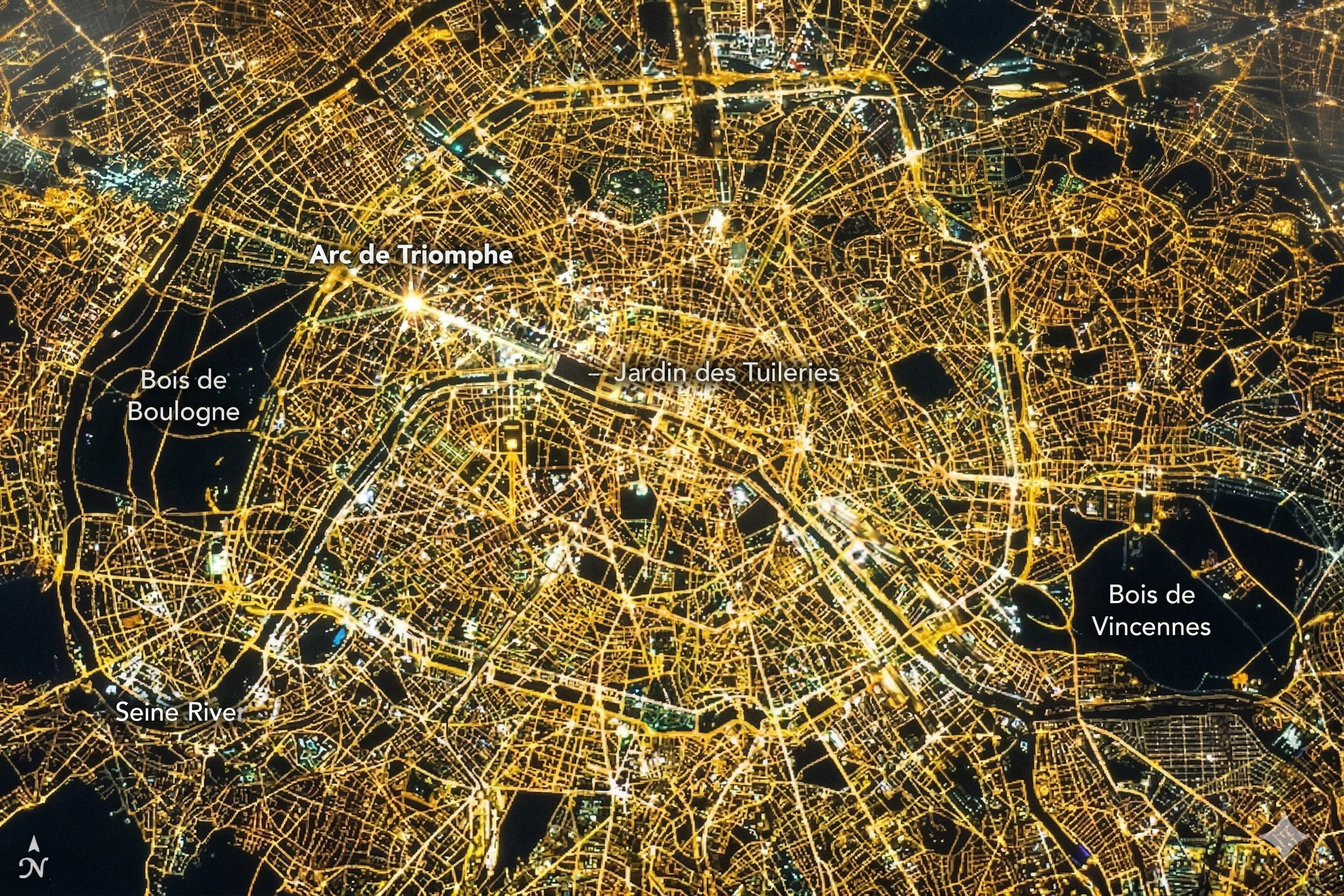
View from space, Paris at night reveals rivers, avenues, and neighborhoods in a golden network visible from 400 km altitude, according to NASA images.
In records released by NASA, based on images captured by astronauts aboard the International Space Station, the city of Paris appears at night as an extremely organized luminous network, visible from about 400 kilometers altitude — the average height of the station’s orbit. The level of detail in these images not only impresses visually but also accurately reveals the urban structure of the French capital: it is possible to distinguish the winding path of the Seine River, identify major avenues radiating from the historic center, and observe the clear division between densely illuminated central areas and peripheral regions with distinct patterns of occupation.
According to analyses published on the official NASA Earth Observatory portal, these images do not represent isolated records, but are part of a consistent set of orbital observations that demonstrate how artificial lighting has transformed large cities into highly visible structures from space. The material is part of a series of studies on urban night light, used even to map population growth, energy consumption, and urbanization patterns on a global scale.
Urban lights transform Paris into a golden network visible from space
The French capital stands out particularly for one factor: its organized and historically planned urban lighting, which creates a coherent and continuous pattern when viewed from space.
-
iPhone 17 reaches historic low price with 256 GB, 120 Hz display, and drops to R$ 5,703 on Shopee, featuring A19 chip, dual 48 MP cameras, battery life of up to 30 hours, and advanced AI features.

-
Trip to Mars getting closer: Pulsar Fusion, from the UK, advances with plasma ignition in fusion engine and could drastically reduce space travel time, making crewed missions faster, safer, and economically viable.

-
Made with recycled plastic, a Lego-inspired brick builds a 180 m² house in 15 days, providing thermal comfort, preventing moisture, and turning waste into income, kits, and accelerated construction in the country.

-
A robot with a silicone face and 26 facial motors learns to move its lips accurately by observing its own reflection like a child, then analyzes hours of videos on YouTube to reproduce how humans speak and sing, now articulating words in several languages, has already recorded a music album generated by AI, and is beginning to cross the uncanny valley that causes people to reject almost human robots.


Unlike cities with more irregular growth, Paris presents a well-defined radial structure, the result of centuries of urban planning, especially after the reforms carried out in the 19th century.

This pattern makes the city appear as a uniform luminous network, with main roads forming clear lines and residential areas creating continuous fills of light.
The Seine River, which cuts through the city, appears as a darker band winding between the illuminated areas, becoming one of the most easily identifiable elements of the image.
Images captured by astronauts confirm visibility to the naked eye
Reports from astronauts who have passed through the ISS reinforce that observation does not depend solely on advanced sensors. In ideal conditions, cities like Paris can be seen with the naked eye, especially during clear nights without cloud cover.
Astronauts describe these cities as “bright clusters” that stand out intensely against darker rural areas.
The difference in brightness between urban zones and natural regions creates such a strong contrast that it allows for clear identification of urban boundaries, something that is not perceptible from the Earth’s surface.
Light distribution reveals urban density and city organization
Nighttime images of Earth are used by scientists for much more than visual purposes. The intensity and distribution of light allow analyses on:
- Urban expansion
- Energy consumption
- Economic activity
- Land use patterns

In the case of Paris, the urban center appears significantly brighter than the peripheral regions, reflecting higher population density and concentration of activities.
This data is used in scientific studies as indirect indicators of urban development, although population estimates are not made directly through visual observation, but through modeling based on satellite data.
Contrast between urban and rural areas makes cities easily identifiable
One of the main factors explaining the visibility of cities from space is contrast.
While urban areas emit continuous light due to street lighting, buildings, and vehicles, rural regions remain significantly darker, creating a striking visual difference.
This contrast transforms cities into clear reference points when viewed from orbit, allowing astronauts to quickly identify large urban centers.
In global images, this effect makes the planet appear as a mosaic of concentrated lights, with highly illuminated regions interspersed with large dark areas.
Orbital technology enhances Earth’s analysis capability at night
In addition to human observation, instruments like the VIIRS sensor allow for capturing images of the Earth with high sensitivity to night light.
These systems detect everything from large cities to smaller sources of illumination, such as oil platforms, vessels, and even wildfires.
The combination of human observation and orbital technology transforms night into a strategic tool for monitoring the planet, enhancing understanding of human activity and natural phenomena.
Historical urban planning contributes to Paris’s visibility
The way Paris was structured throughout history directly contributes to its appearance when viewed from space.
The urban reforms of the 19th century, which reorganized the city with wide avenues and defined layouts, created a foundation that today reflects in the distribution of lighting.
This historical planning directly influences how the city appears in orbital images, standing out compared to cities with less structured growth.
Earth observation reveals human impact on a global scale
The images of Paris at night are just one example of a broader phenomenon: the transformation of the Earth’s surface by human activity.
When viewed from space, cities like Paris, London, New York, and Tokyo form interconnected luminous networks that reveal the scale of global urbanization.
This pattern of light not only impresses visually but also highlights the energy and environmental impact of modern societies.
The observation of Paris from the ISS demonstrates how artificial lighting has transformed cities into structures visible from hundreds of kilometers altitude.
With a golden network that reveals rivers, avenues, and entire neighborhoods, the city becomes one of the clearest examples of how urban planning and energy consumption shape the appearance of the planet when viewed from space.
More than a visual spectacle, these images represent a powerful scientific tool, capable of translating human presence into luminous patterns that traverse the darkness and make visible, from orbit, the organization of societies on Earth.


Seja o primeiro a reagir!