 Portuguese
  English
  Spanish
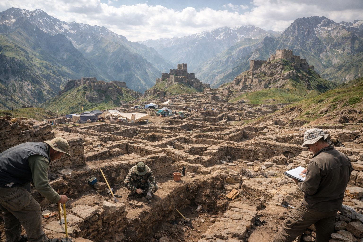
Discovery of Tugunbulak redefines occupation of Central Asia, revealing medieval city at high altitude with complex urban planning, defensive structures, and active role in the economic and cultural dynamics of the Silk Road.
In 2024, a study published in the scientific journal Nature revealed a discovery that directly alters the historical understanding of the occupation of Central Asia. Researchers identified the archaeological site of Tugunbulak, located in southeastern Uzbekistan, as a medieval city of approximately 120 hectares situated between 2,000 and 2,200 meters in altitude, a geographical context that had not been associated with large-scale urban centers until now.
The discovery was conducted by an international team that used remote sensing technology to map invisible structures beneath the mountainous terrain. The data obtained showed that the site was not an isolated or temporary settlement, but rather a structured urban center, with internal organization, functional division, and clear defensive elements. This set of evidence changes the dominant interpretation that the mountainous regions of the Silk Road functioned only as transit corridors.
LiDAR technology with drones revealed an entire city invisible beneath the surface
The central element of this discovery was the use of LiDAR (Light Detection and Ranging), a technology that uses laser pulses to map the terrain with high precision. In the case of Uzbekistan, the sensors were mounted on drones, allowing them to fly over hard-to-reach areas and generate detailed three-dimensional models of the surface.
-
The humanoid robot from China that runs, does flips, and costs less than an economy car has just launched a global version, and the R1 from Unitree will be sold for $4,900 in the United States, Europe, and Asia, making a machine with 26 joints accessible to any small laboratory or enthusiast with the budget of a high-end iPhone.

-
NASA is building a space telescope to find killer asteroids before they hit us, and the unofficial mission emblem features a T-Rex screaming at the sky with two words: never again.

-
Ten undergraduate students received an astronomy homework assignment, began sifting through data on the university’s computer, and ended up discovering the oldest star ever recorded in the universe, a cosmic immigrant that formed shortly after the Big Bang and was wandering alone towards the Milky Way.

-
Scientists reveal that Saturn’s rings may have formed after the destruction of a moon, and a study indicates that the planet’s bright structure is only 100 million years old.

By processing the data, researchers were able to digitally remove vegetation and identify geometric patterns inconsistent with natural formations. What emerged was the layout of a complete city, with walls, aligned structures, spatial divisions, and fortified areas, all organized coherently.
The most relevant point is that these structures remained invisible for centuries, not because they were deeply buried, but because they were integrated into the terrain and covered by vegetation and natural irregularities of the land.
Scale of 120 hectares indicates permanent occupation and advanced urban planning
The size of the site is one of the most impactful factors. At about 120 hectares, Tugunbulak cannot be interpreted as a waystation or transient settlement. This scale requires a significant amount of labor, social organization, and long-term planning.
The evidence points to a city with a defined functional structure, where different areas played distinct roles within the urban system. This includes zones that were likely residential, central areas with administrative or ceremonial functions, and fortified sectors indicating concern for defense and territorial control.
The very spatial organization suggests that the city was built in a planned manner, rather than growing organically or chaotically.
Four fortified citadels reveal social hierarchy and strategic control
One of the most relevant elements identified at the site is the presence of four fortified citadels, elevated structures that stand out within the urban landscape. These citadels not only reinforce the idea of planning but also indicate an advanced level of political organization.
The existence of these structures suggests the presence of a defined social hierarchy, with spaces designated for control, administration, or defense. The elevated position of these citadels also indicates a clear strategy of utilizing the terrain for surveillance and protection.
These elements demonstrate that the city not only existed but operated within a structured logic of power and territorial organization.
Location above 2,000 meters challenges traditional models of medieval urbanization
The discovery of a city of this scale in a region above 2,000 meters in altitude represents a direct challenge to classical models of medieval urbanization. Historically, urban centers were associated with regions that had easy access to resources, especially water, agriculture, and stable trade routes.
However, Tugunbulak is located in an environment that presents more severe climatic conditions, rugged terrain, and natural limitations for intensive agriculture. This indicates that the choice of location was not random, but rather strategic.
The city was likely integrated into trade networks that justified its elevated position, possibly functioning as a control or articulation point within the Silk Road.
Silk Road included permanent urban centers and not just trade routes
The traditional interpretation of the Silk Road as a circulation system between large urban centers is directly affected by this discovery. Tugunbulak demonstrates that there was permanent urban occupation in regions considered peripheral or hard to access.
This suggests that the Silk Road should be understood as a more complex system, which included not only the transport of goods but also urban infrastructure, territorial control, and the continuous presence of organized populations.
The existence of cities like Tugunbulak indicates that the trade network was supported by a much broader territorial base than previously thought.
Architecture adapted to the terrain shows technical mastery and environmental knowledge
Another relevant aspect of the discovery is the way the structures were built in harmony with the environment. The use of stone as the main material indicates adaptation to local conditions and a quest for durability in unstable terrain.
Moreover, the arrangement of the buildings suggests that the inhabitants had detailed knowledge of the terrain and knew how to use it to their advantage, both for defense and for organizing urban space.
This type of integration between architecture and environment reinforces the idea that the city was not improvised, but rather the result of planning and accumulated knowledge.
Presence of other sites in the region indicates regional pattern of urbanization in high mountains
The discovery of Tugunbulak did not occur in isolation. Researchers also identified the site of Tashbulak, which has similar characteristics, although on a smaller scale.
The presence of multiple settlements in the same region indicates a regional pattern of occupation, suggesting that urbanization at high altitude was not an exception, but part of a broader strategy.
This set of evidence amplifies the impact of the discovery and reinforces the need to revise historical models regarding the occupation of Central Asia.
Modern technology redefines limits of archaeology and reveals cities where no one was looking
The use of technologies such as LiDAR has significantly expanded the reach of archaeology, especially in hard-to-access regions. In the case of Tugunbulak, the technology was essential in revealing an entire city that remained unknown for centuries.
This advancement indicates that there are still many areas of the planet where similar structures may be hidden, awaiting identification through more advanced methods. Archaeology, in this context, increasingly depends on the integration of technology and field research.
What else may be hidden in mountainous regions still unexplored?
The discovery of a large-scale medieval city at over 2,000 meters in altitude raises an inevitable question: how many other urban centers remain hidden in regions considered improbable for human occupation?
The evidence shows that the history of human occupation is still far from being fully understood, especially in areas that have not been traditionally prioritized by archaeological research.
In light of this, a new perspective emerges: the map of ancient civilizations may be much larger, more complex, and more surprising than any current model can explain. Now I want to know your analysis: do you think there are still entire cities hidden in regions where no one is looking?


Seja o primeiro a reagir!