 Portuguese
  English
  Spanish
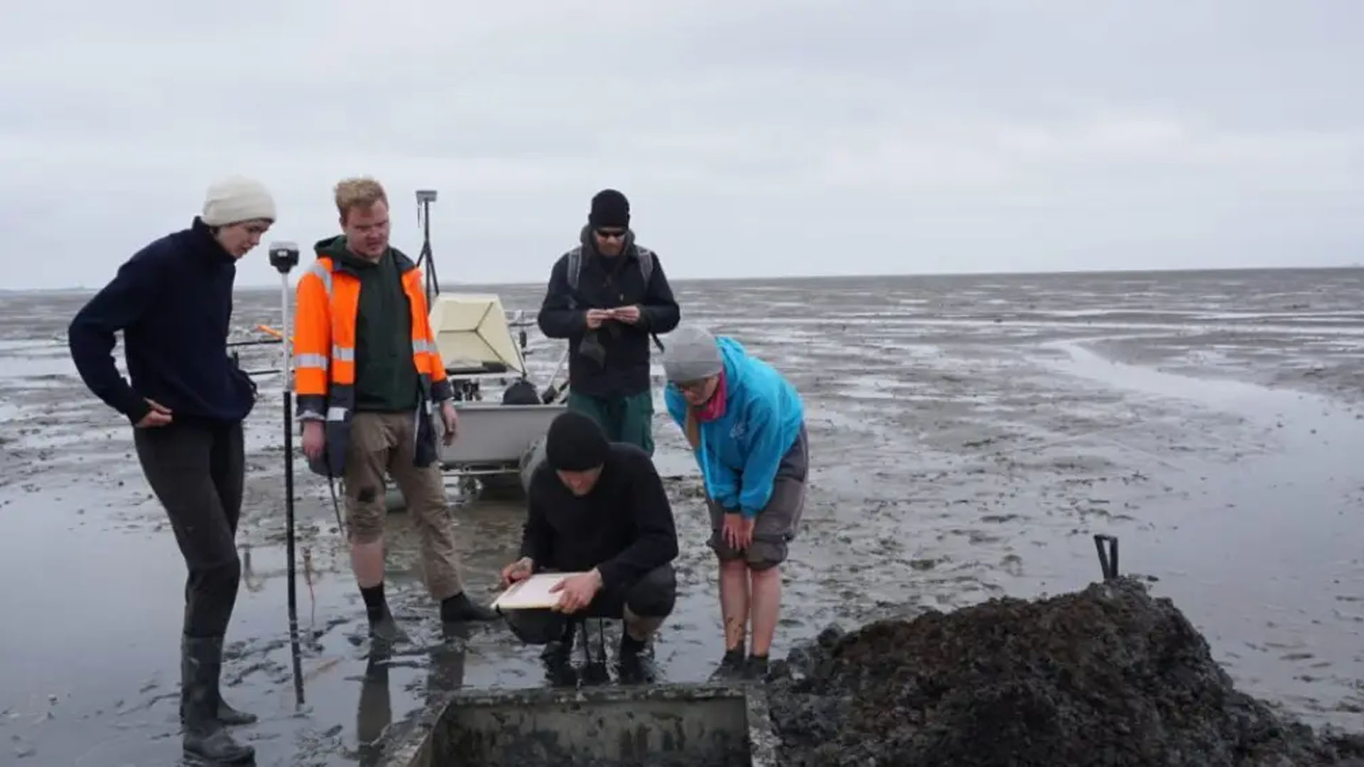
Researchers From Germany Confirm the “Submerged City” With Advanced Geophysical Methods and Reconstruct Part of the Medieval Settlement That Sank During the Grote Mandrenke.
Almost seven centuries after being swept away by a historic storm, the medieval city of Rungholt, on the northern German coast, is no longer a legend. The name has survived folklore, but the traces remain beneath the tides and mud of the Wadden Sea.
In 2023 and 2024, an interdisciplinary team brought back the lost urban layout. The Main Church, dikes, drainage walls, and human mounds (terps) returned to the scientific map.
The tragedy that buried Rungholt occurred in January 1362, during the so-called Second Saint Marcellus Flood (Grote Mandrenke), when a storm tide reshaped large sections of the North Sea coast. Museums and German chroniclers record the event as a turning point for medieval coastal communities.
-
With 1,066 acrylic panels, the building known as the friendly alien is supported by a steel skeleton, has a façade that functions as a giant screen, and impresses the world without any internal columns.
-
Scientists warn that a comet about 1 km in size that has started to release gases may actually change direction in space. It was spotted by NASA and surprises with potential impacts near Earth.
-
These living root bridges and ladders are over 700 years old and help indigenous people survive in one of the rainiest regions in the world.

-
From sertanejo star to international investor: Ana Castela invests millions in a mansion in the USA, creates a themed accommodation in Orlando, and shows that the “boiadeira” also wants to grow away from the stage.


The new surveys validate what late documents suggested: Rungholt was a prosperous port settlement, playing a regional role in ecclesiastical and agricultural trade. Confirmation came from field measurements and laboratory analyses that resolved a puzzle debated for over a century.
Using unprecedented data, scientists connected scattered pieces of the puzzle: they located the foundation of a church approximately 40 x 15 meters, rectified dozens of terps, and aligned these structures with channels and dikes that protected the cultivated plain.
The result is a coherent portrait of a medieval cultural landscape submerged.
Where Is Rungholt and What Was Actually Confirmed
Rungholt was located in the current UNESCO World Heritage Wadden Sea, a mosaic of sandy banks and intertidal mudflats between the Netherlands, Germany, and Denmark. The region is dynamic, with strong tides and sensitive ecosystems, complicating and enhancing every archaeological find.
According to the article Scientific Reports (Nature) and technical notes from the University of Kiel, researchers reconstructed a set that spans at least 10 km², with 64 terps, a dense drainage network, a sea dike, and an associated port site.
At the center, the geophysical signature of the Main Church guided drilling and small verification excavations.
Based on the mapped structures and historical comparisons, the team estimates 1,000–1,300 inhabitants at the peak of settlement, reinforcing the interpretation of an active medieval port and territory intensely reclaimed from the sea through dikes and channels. It’s Not “Atlantis”: It’s Coastal Archaeology in High Resolution.
How the Submerged City Was Mapped: Magnetic Gradiometry, EMI, and Shallow Seismics
To “see” beneath the mud, the team applied multichannel magnetic gradiometry during low tide, generating anomaly maps that outline streets, terps, and foundations. Key points received electromagnetic induction (EMI) measurements and shallow reflection seismic profiles in shallow waters. This geophysical package reduced uncertainties and guided fine fieldwork.
Then came vibro-cores and geoarchaeological analyses. The sediment cores tied together dates, environments, and phases of occupation, revealing how human use transformed the swamp into fields and, later, lowered the land through drainage and peat extraction.
The integrated reading allowed for rectifying ancient structures already recorded and discovering new ones. In 2024, an eight-day campaign added 19 terps to the inventory and tested, with 1 m² wells, sections of the church foundation to validate the shapes seen in the magnetometer.
There is urgency. Coastal erosion is already erasing parts of this evidence, often preserved only as “negatives” in the substrate. The authors themselves are calling for intensified investigations while the natural preservation window allows.
Ultimately, the methodology created a replicable model for other submerged sites in the Wadden Sea, where natural processes and human actions have intertwined for millennia. Technology and archaeology walk hand in hand at the boundary between land and sea.
What the Finds Reveal About Commerce and Daily Life
The maps and finds indicate imported goods and materials of high value, such as glazed ceramics, bronze pots, and even Hispano-Moresque faience scattered across different areas of the settlement. This indicates transregional exchange networks and unusual economic capability for a coastal village.
The reports from 2023–2024 also document molded bricks, metal objects, and medieval ceramics recovered at low tide, reinforcing a structured urban life around the large church and the port with a sluice-gate.
Regarding food, archaeozoological evidence from the Wadden Sea region shows a combined consumption of seafood and meats from sheep and cattle in medieval coastal sites. This is useful regional reference for interpreting Rungholt, although the specific samples from the city are still under analysis.
Why Rungholt Matters for the Discussion on Climate, Land Use, and Coastal Risk
The data reinforce a recurring paradox: the same engineering that allowed for production on wet soil — dikes, drainage, and peat cutting — lowered the land and increased vulnerability to storm tides. In 1362, the system failed catastrophically.
The Wadden Sea is a World Heritage Site and a target for trilateral climate management; the UNESCO committee calls for an assessment of cumulative impacts from ports, extraction, and energy, now against the backdrop of sea level rise. Studying Rungholt helps calibrate modern coastal adaptation with lessons from the past.
What do you think is more decisive in the collapse of Rungholt, greed in advancing into risky areas or an exceptional storm that would have defeated any medieval dike? Leave your comment.


-

-

2 pessoas reagiram a isso.