 Portuguese
  English
  Spanish
Using Old Satellites, Scientists Made an Incredible Discovery: Underground Aqueducts Over 3,000 Years Old Have Been Revealed
Scientists have been using an unlikely tool to locate underground aqueducts over 3,000 years old: American satellites from the Cold War era. A research team in Spain, led by the Catalan Institute of Classical Archaeology, is leveraging images from the HEXAGON satellite series, known as Big Bird, to enhance the detection of ancient underground irrigation systems, known as qanats, in arid regions of the Middle East and North Africa.
These underground aqueducts, essential for water distribution in desert environments, are formed by a series of regularly spaced ventilation shafts, making them visible in aerial images.
To improve the accuracy of identifying these underground aqueducts, the research team developed a machine learning model that combines images captured by the HEXAGON satellites with artificial intelligence (AI)-generated images.
-
Remains with battle wounds of over 100 soldiers from the Roman Empire are found beneath a football field in Vienna, leaving everyone surprised.

-
Elon Musk notes Brazil and lowers the price of his internet, Starlink, promising to connect all corners of the country with affordable plans, 10,000 satellites, and 1 million active users in the national territory!

-
Man creates an infinite source of FREE electricity at home with a PVC wind turbine using a repurposed motor.

-
An aquatic seed consumed for centuries in Asia is going viral in the West after studies highlighted its antioxidant compounds and potential anti-inflammatory properties. It pops like popcorn, has low fat content, and is already being called the new functional snack.


What Are Qanats?
Qanats are systems of underground channels designed to transport water from highland or mountainous areas to drier regions.
These systems allowed ancient civilizations to thrive in areas where water would be scarce. Originating about 3,000 years ago, many qanats are still in use today. They represent an impressive technological advancement for their time, built on hydraulic and geological principles that ensured a constant flow of water without the use of pumps.
The innovation of qanats lies in their simplicity and efficiency. Vertical shafts dug along the canal’s route provide ventilation and access for maintenance, while the underground tunnel transports fresh water to areas where it would be impossible to live without this source of irrigation.
In some places, such as Iran, these systems have been so important that some have been included on the UNESCO World Heritage list, recognizing their historical and cultural value.
The Reuse of Cold War Satellites to Find Underground Aqueducts
The HEXAGON satellites, built by Lockheed Corp. and used by the United States between 1971 and 1986, were originally designed for reconnaissance missions during the Cold War.
These satellites were equipped with two high-resolution film cameras that produced stereo images. With the ability to capture objects smaller than two feet wide from an altitude of 100 miles, the satellites captured detailed images of 877 million square miles of Earth’s surface.
These images, despite being old, remain a valuable source of data. By feeding these images into a machine learning model, the Spanish research team was able to enhance the detection of qanats, which appear as lines of circular ventilation shafts seen from above.
By combining real images with AI-generated images, the model was able to generalize the representation of qanats across different landscapes, resulting in an 88% success rate in identifying the underground systems.
Application of the Model in Different Regions
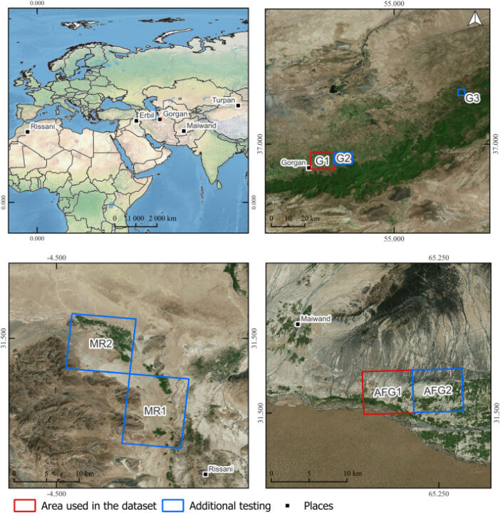
To demonstrate the model’s effectiveness, the team chose three regions known for their ancient qanat systems: Maiwand in Afghanistan; the Gorgan Plain in Iran; and an area west of Rissani in Morocco.
These areas feature diverse landscapes, from arid deserts to mountainous plains, making them ideal for testing the model’s ability to identify qanats across different terrain types.
By analyzing satellite and AI images, the model was trained to recognize the lines of ventilation shafts that indicate the presence of qanats. These access shafts, used for both ventilation and maintenance, are essential for the functioning of the underground systems and are one of the key indicators of a qanat’s existence.
The combination of real and AI-generated data allowed the model to eliminate most false positives, making the identification process more efficient.
Historical and Future Importance of Qanats
Qanats represent one of the greatest feats of hydraulic engineering in the ancient world. Their importance goes beyond water distribution; they enabled the development of cities and settlements in inhospitable regions, changing the course of history in areas like the Middle East and North Africa.
The study by the Spanish team not only helps identify these ancient systems but also provides a new tool for archaeologists and historians to study the expansion and impact of ancient civilizations in arid regions.
The reuse of Cold War technologies, such as the HEXAGON satellites, to study structures that are 3,000 years old demonstrates how modern science can offer new insights into the past.
Additionally, applying this model in different regions might open doors to identifying other unmapped qanat systems, providing valuable information about the history of water use in arid regions.
This knowledge could be crucial in addressing modern challenges related to water scarcity, especially in areas that still rely on traditional irrigation systems.
The discovery and mapping of qanats using Cold War satellites and artificial intelligence represent a significant advancement in the field of archaeology. By combining historical images with modern technologies, the Spanish research team was able to develop an effective model for identifying these ancient systems across different landscapes.
This study not only sheds light on the past but may also provide solutions to current problems related to sustainable water use in arid regions.


Seja o primeiro a reagir!