 Portuguese
  English
  Spanish
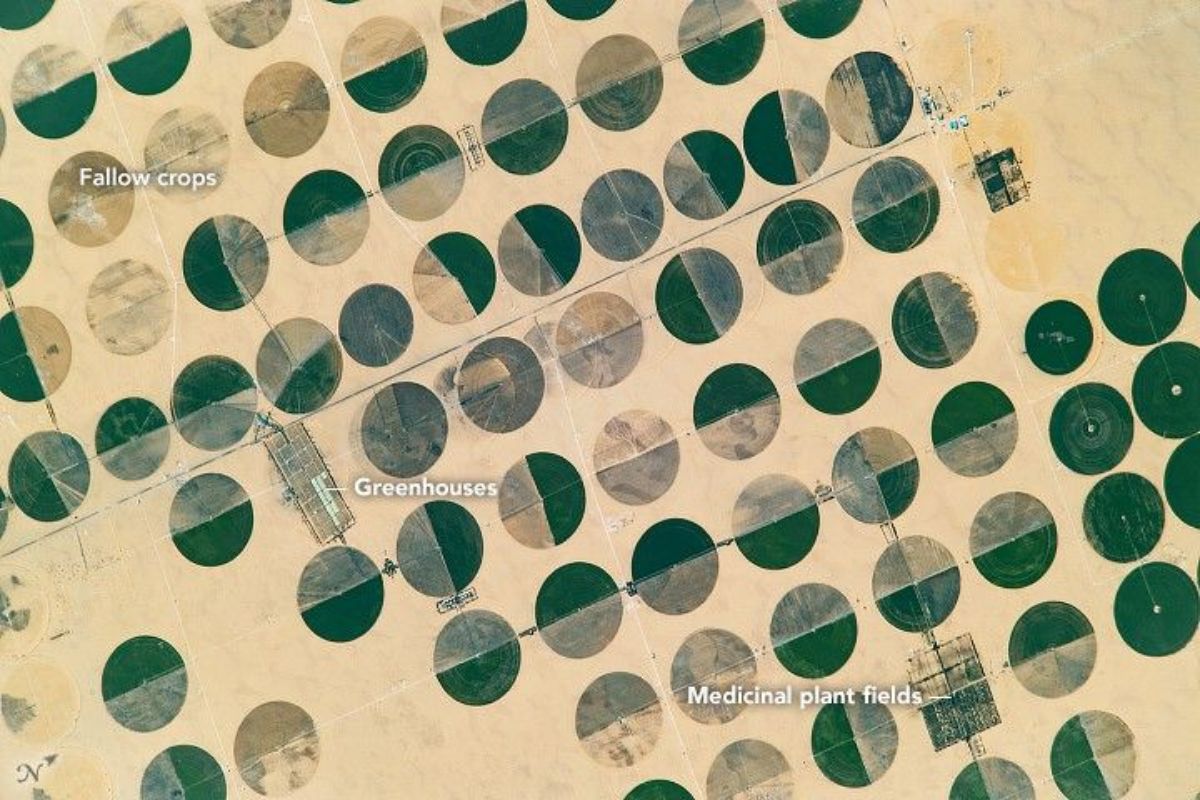
The circles in the fields appear 290 km from the nearest city and grow between 1998 and 2019 thanks to central pivot irrigation with groundwater from the Nubian Sandstone Aquifer.
The circles in the fields seen from space transform Sharq El Owainat, in southwestern Egypt, into a rare contrast: vegetation in the midst of the Sahara Desert landscape. The image captured by an astronaut aboard the International Space Station shows circular patterns that look like they were drawn with a ruler, but are a direct result of an agricultural technique.
What supports these circles in the fields is a system designed to use water efficiently in the desert. There, central pivot irrigation rotates around a fixed point, creating circular fields that multiply over time and reveal, in a series of images, how the agricultural area expanded from 1998 to 2019.
Where the circles in the fields are located and why the place attracts attention
Sharq El Owainat is a remote agricultural outpost in the Sahara Desert. The area is approximately 290 kilometers from the nearest city and about 210 kilometers from the Toshka lakes, which reinforces the feeling of total isolation when looking at the map.
-
40% still call it a fraud: Soviets monitored Apollo, mirrors on the Moon still return lasers today and rocks confirm it; in 2026, 4 astronauts will return to lunar orbit and the race restarts against China.

-
New list shows over 50 cell phones compatible with Starlink without an antenna: direct connection to satellites in low orbit, coverage in areas without signal, initial support for SMS and emergencies, and forecast for global mobile internet.

-
Not even Starlink, Elon Musk’s internet, has succeeded: Iran enters the 37th day of a digital blackout with over 864 hours without internet, surpassing all previously recorded blockades and forcing millions to use the isolated national network after military attacks.

-
China arms a solar panel shield against the advance of the desert: a 1 GW project in Ningxia creates shade for shrubs and goji, and the official plan aims for 253 GW by 2030 to recover 7,000 km².
It is precisely this distance that makes the circles in the fields so impressive. In a country where more than 95% of the territory is uninhabitable desert and the average annual precipitation cited at the base is 0 millimeters, any continuous green patch already attracts attention. When that patch turns into a perfect geometric pattern, the visual effect becomes even more striking.
What creates the perfect circular shape in the middle of the Sahara
The circles in the fields are the result of central pivot irrigation, a method described as efficient for conserving water in agriculture. It works like this: groundwater is extracted from wells at the center of the circle and travels through long rotating pipes, which sprinkle or drip water while rotating around the pivot.
The final design is practically inevitable: if the equipment rotates around the center, the field is born circular. The series of satellite images cited at the base helps visualize the process at scale, showing the emergence and expansion of these circles over more than two decades.
The water that feeds the fields comes from underground
In the case of Sharq El Owainat, the base points to the Nubian Sandstone Aquifer System as the source that allows small agricultural areas to survive in the desert. This groundwater, stored underground for long periods, is described as essential for Egyptians living far from the Nile River.
Another important detail mentioned at the base is the quality: the water in the region has low salt content, which favors cultivation in an environment where salinization could become a silent obstacle to productivity.
What is being cultivated in the circles in the fields
From the colors and patterns observed, the base indicates that part of the crops likely includes potatoes, wheat, and also medicinal and aromatic plants, such as chamomile. The variation in tones helps distinguish areas at different stages of cultivation and management.
There are also circles in a light beige tone that, according to the base, likely underwent controlled burns to remove excess plant material and clear the area for the next planting. This detail shows that, in addition to irrigation, the project requires constant management of the agricultural cycle.
Logistics in the desert: where this production goes
The circles in the fields are not just a visual phenomenon; they are part of a logistics chain. The base describes that the crops, intended for the population of New Valley province, travel along desert roads with connections to Abu Simbel, the Dakhla Oasis, and Sharq El Owainat Airport.
This explains why the area is not limited to planting but needs to function as a complete system: production, distribution, and minimal infrastructure to keep an agricultural hub operating far from the major traditional corridors.
A growth that can be seen between 1998 and 2019


The base also describes a set of images that highlight how the agricultural project developed between January 1998 and March 2019, using a long series of over 150 images. During this period, the emergence of more circular fields and subtle changes within the fields themselves become visible.
Each circle appears to be about 800 meters in diameter, according to the base, which helps to scale the actual size of what looks “miniature” when viewed from space. It is agriculture at scale, designed by mechanics, water, and repetition.
The dunes also move and enter the satellite’s history
Even with agricultural growth, the Sahara remains present in the picture. The base highlights the presence of drifting sand dunes, visible especially in part of the images, as a common phenomenon in sandy deserts with constant winds.
This contrast is what makes Sharq El Owainat such a visual case: on one side, the geometry of the circles in the fields; on the other, the living relief of the desert changing with the wind, reminding us that the scenery never stays completely static.
Do you think these circles in the fields are an impressive example of human adaptation to the desert or a type of agriculture that will always depend on a delicate balance with groundwater?


Seja o primeiro a reagir!