 Portuguese
  English
  Spanish
Station begins with persistent rain, above-average heat, and gradual advance of cold, influenced by climatic phenomena that prolong instability and delay more intense temperature drops in various regions of the country.
Autumn 2026 began on March 20, at 11:45 AM, Brasília time, under a scenario of instability in several areas of the country, with forecasts of persistent rain, slower advance of intense cold, and the possibility of frost starting in the second half of the season.
The combination of cold fronts along the coast, still high humidity, and the influence of a coastal El Niño, in addition to the subsequent formation of the classic El Niño, helps explain why the transition to stronger cold tends to occur gradually this year.
In Minas Gerais, one of the states most affected by summer rains, the start of the season coincided with weather alerts from the National Institute of Meteorology for much of the territory.
-
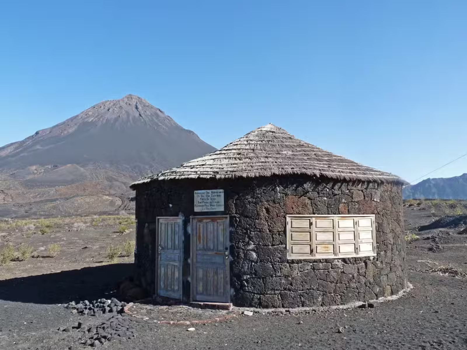
Inside an active volcano in Africa, residents use volcanic rocks to build houses in an impressive setting.
-
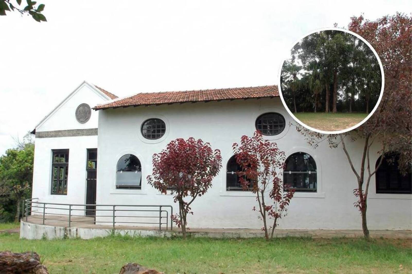
After 14 years of waiting, a rammed earth mansion built in 1702 in the North Zone of São Paulo will become a park with leisure facilities and green areas, with a million-dollar investment.
-
With 2 unfinished nuclear reactors, up to 25 billion in costs, and proven fraud, the Nukegate case has left 800,000 consumers still paying today for energy that will never be produced.

-
The household appliance that consumes the most energy in Brazilian homes is not the air conditioner; it is located in the smallest room of the house, is used daily, and can account for up to 25% of the electricity bill, while an alternative in the same outlet can reduce this cost by up to 75%.


The warnings indicated rain between 20 and 30 millimeters per hour, with winds of 40 to 60 km/h, as well as areas at higher risk of storms, with the possibility of power outages, falling branches, flooding, and electrical discharges.
Autumn rains maintain elevated pattern in Southeast and Central-West
The trend outlined by Climatempo for autumn shows that April would still be a month of frequent showers in the Southeast and Central-West, before a more consistent weakening of humidity starting in the second half of May.
In this interval, cold fronts should advance more regularly along the coasts of the South and Southeast, maintaining cloudiness and rain especially in eastern São Paulo, Rio de Janeiro, and Espírito Santo.
In the case of Minas Gerais, the first typical cold front of the season was expected in the second half of April, with a moderate drop in temperatures also affecting other states in the Southeast.
In the Central-West, the initial cooling was expected to reach areas of Mato Grosso do Sul and Mato Grosso, still not characterizing the first period of more intense cold of the year.
A more pronounced reduction in temperature was considered more likely in June, when polar air masses tend to advance more forcefully over the interior of the country.
At this stage, in addition to Minas Gerais, the chance of a more significant drop in temperatures would also increase in Goiás and the Federal District, within the typical behavior of the transition season to winter.
Frost risk increases from May and gains strength in June
Although autumn 2026 is projected to be less cold than usual in much of the country, this does not eliminate the possibility of localized episodes of strong cold, especially between the end of May and June.
INMET itself highlights that the season usually marks the beginning of favorable conditions for frosts in the South, Southeast, and Mato Grosso do Sul, as well as cold snaps in the southern part of the North Region.
In the assessment released by Climatempo, the risk of frost in Minas Gerais and São Paulo appears already in the second half of May, but the probability increases more clearly throughout June.
This means that the season should alternate between periods of above-expected heat and occasional incursions of cold air, a contrast that tends to amplify the feeling of abrupt weather changes between dawn and the afternoon period.
This scenario helps dispel the expectation of an autumn marked by continuous cold right from the first days, something common in the imagination of part of the population.
In 2026, the predominant signal is of above-average temperatures in broad areas of the country, with more significant cooling appearing later and being less lasting, especially outside the South Region and the mountainous areas of the Southeast.
El Niño influence prolongs rain and alters climatic pattern
Although the term El Niño appears associated with this year’s autumn, the situation requires precision: according to Climatempo, the classic phenomenon was not yet configured at the beginning of the season.
The scenario observed in March was one of thermal neutrality in the Equatorial Pacific, but already with a coastal El Niño along the coasts of Peru and Ecuador, a condition that alters wind circulation and favors more rain over the South, in addition to prolonging the transport of moisture to the Central-West and Southeast.
The expectation presented by the meteorological company is that a new episode of classic El Niño will consolidate only at the end of autumn or the beginning of winter.
Until then, the most immediate effect of this coastal warming would be to maintain fuel for rain showers for a longer time in the central-southern part of the country, while sustaining periods of above-normal warming in various areas.
In the South, where summer ended with a rainfall deficit in several areas, the change in pattern tends to be more noticeable starting in May, with an increase in the frequency of precipitation and the chance of storms in the three states.
Still, Climatempo itself emphasizes that, at this moment, it is premature to compare the behavior of autumn 2026 with extreme episodes from the recent past, as the greater risk associated with El Niño tends to grow especially in the second half.
Regional forecast indicates contrasts between rain and temperature
For the South Region, the forecast indicates above-normal rainfall volumes mainly in Rio Grande do Sul, central and western Santa Catarina, and western and southern Paraná, a scenario consistent with the influence of warming in the Pacific and with the increased frequency of cold fronts.
At the same time, most areas of the Southeast and Central-West should record accumulations close to the historical average, without indicating an exceptionally dry or exceptionally rainy season in the overall context of these regions.
In the Northeast, the expected behavior is of above-average rainfall in much of the region, with potential for more intense episodes in the capitals between Salvador and Natal.
In the North, the predominant trend is for below-average precipitation in most of the territory, with the exception of Amapá, where Climatempo projects above-normal volumes during the season.
In practice, autumn 2026 is shaping up less as an immediate gateway to harsh cold and more as a prolonged transition period, with still relevant rain, persistent heat at various times, and incursions of cold air distributed unevenly across the country.
For those expecting a sharp seasonal change already in March, the data gathered by INMET and Climatempo indicate a slower climatic calendar, with strong cold concentrated further ahead and with a greater chance of impact between May and June.


Seja o primeiro a reagir!