 Portuguese
  English
  Spanish
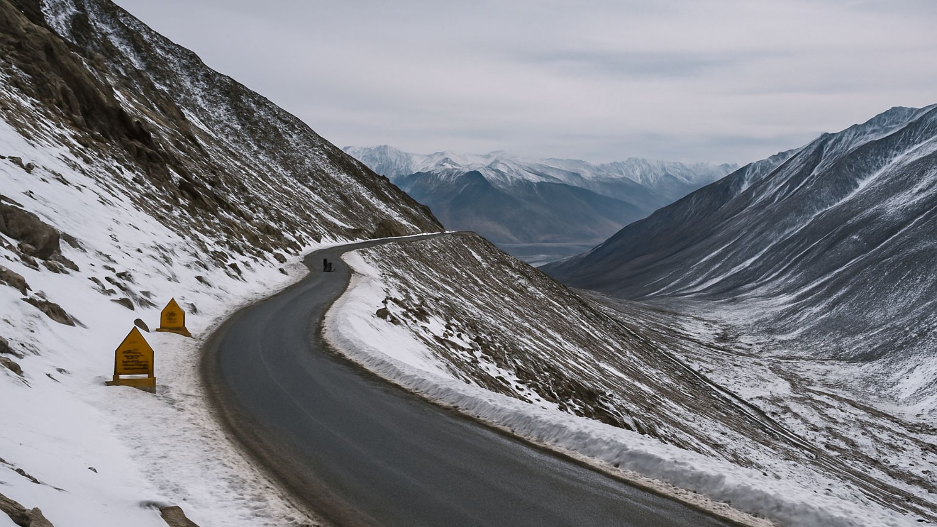
High-Altitude Road Combining Military Function, Vital Connection for Ladakh Communities, and Intense Tourist Traffic in One of the Most Extreme Environments of the Himalayas.
The road that crosses the Khardung La pass, in northern India, combines three functions often cited by local authorities: strategic military corridor, essential link for isolated communities, and route sought by travelers interested in extreme altitude.
Officially at 5,359 meters above sea level, the pass is among the highest drivable roads in the world and connects the Leh region to the Nubra Valley in the Ladakh Union Territory.
Maintained by the Border Roads Organisation (BRO), the road is currently the main access route between the Indus River valley and villages located around the Karakoram mountain range.
-
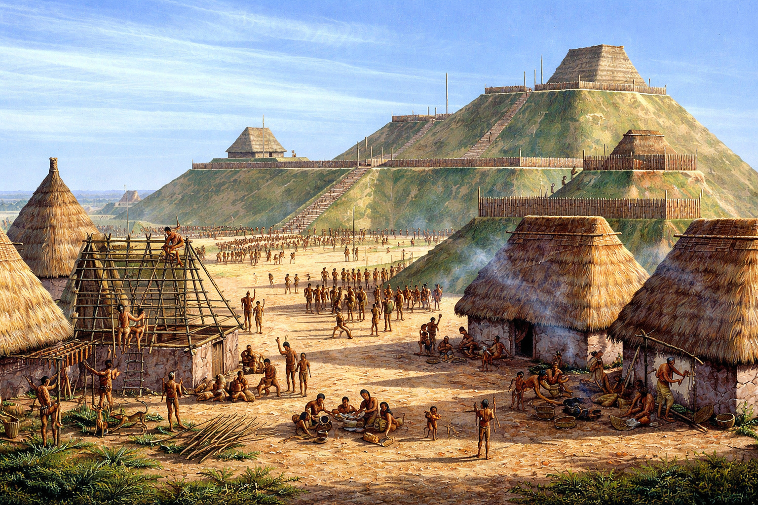
With over 14 million baskets of earth moved, an ancient North American metropolis built a monumental pyramid of 30 meters and established a city with 20,000 inhabitants nearly a thousand years ago.
-
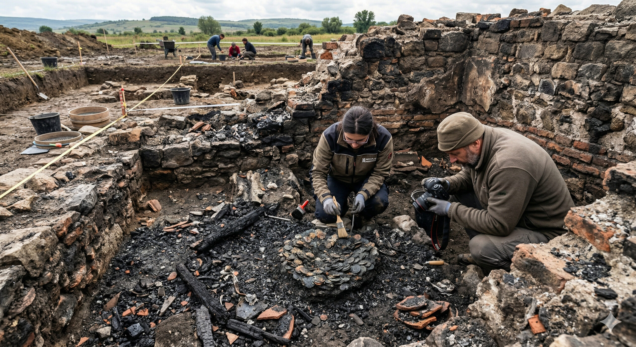
A 1,900-year-old treasure emerges from a Roman house destroyed by fire and sealed since antiquity in Romania, with coins and metals fused among the ashes.
-
The Brazilian colonial city that stopped in time and shares territory with a rocket launch base.

-
79-year-old woman challenges limits, visits 193 countries in the world after 56 years of planning and reveals the behind-the-scenes of a global journey that few have managed to accomplish.


Road Connection Between Leh and the Nubra Valley
The paved route starts in Leh and ascends approximately 39 kilometers to the top of Khardung La before descending towards Diskit and other localities in the Nubra Valley.
The route serves as a logistical axis for an estimated population of just over 20 thousand residents, who rely on land transport for supplies, healthcare services, and mobility.
The road was built in the 1970s for military purposes and opened to civilian traffic in 1988.
Since then, tourist jeeps, buses, private vehicles, and army trucks share the corridor, which is considered strategic by the Indian government for the movement of troops and supplies to the border region.
Military Construction and Engineering Challenges
The road crosses fragile slopes, loose gravel areas, and sections formed by glacial deposits.
At higher points, the track is between 3 and 4 meters wide, which requires reduced speed when heavy vehicles meet.
According to engineers from the BRO, the absence of physical barriers in parts of the route increases the need for careful driving during icy or foggy periods.
The main paving was completed over the last decade, but there are still sections prone to potholes, patches, and damage caused by landslides.
During the rainy season or thaw, mud and accumulated gravel can hinder traction even in all-wheel-drive vehicles.
Impact of Extreme Altitude on Travelers
Altitude is identified by health professionals as the most critical factor for those attempting to cross Khardung La.
Above 5,300 meters, low atmospheric pressure reduces oxygen availability, a condition associated with acute mountain sickness.

Studies on altitude sickness show a higher incidence of symptoms such as headaches, nausea, and dizziness when the ascent occurs rapidly and without acclimatization.
For this reason, Ladakh authorities recommend that visitors stay for at least two days in Leh before proceeding to the pass.
Tour agencies and experienced drivers reinforce this guidance, reporting that acclimatization reduces emergency services at Khardung La and other passes in the region.
Heavy vehicles face additional limitations.
In segments with inclines close to 8%, engines require more effort, and brake temperature must be monitored during long descents.
On snowy or icy days, according to the BRO, traction loss becomes more frequent, especially in curves with accumulated gravel.
Harsh Climate and Unpredictable Conditions
Even in summer, negative temperatures are common at the top.
Tour operators report a wind chill factor below -20 °C on windy days, which requires specific protective clothing.
In the afternoon, fog formation and gusts that reduce visibility to a few meters are common, increasing crossing time.
Between late autumn and early spring, heavy snowfall affects the pass.
The BRO adopts the strategy of keeping the road open whenever possible, conducting snow removal operations after storms.
In recent winters, crews have managed to maintain passability, although with temporary closures after avalanches or excessive ice buildup.
Continuous Maintenance and Winter Operations

Maintenance requires constant movement of machinery, such as excavators and snow blowers, due to deposits that can reach several meters in height.
At certain points, snow walls form on the sides of the road and need to be cut down to widen the traffic corridor.
Landslides, thaw erosion, and small glacier movement necessitate periodic reconstructions.
According to official reports from the Ministry of Defense, these factors pressure the budget allocated to the strategic roadway network of Ladakh.
Essential Link for the Nubra Valley
Khardung La is the central land link between Leh and villages like Diskit, Hunder, Turtuk, and Panamik.
Indian census data indicate that Nubra is home to just over 22 thousand inhabitants, whose daily routines rely on the transport of food, medicines, school materials, and construction supplies.
Before the civil opening, access was mainly via trails used by caravans.
The reduction of travel time to just a few hours changed the flow of goods, facilitated medical care, and shortened the route to the administrative center of the territory.
During the summer season, traffic increases with the arrival of military convoys, supply trucks, and groups of motorcyclists.
Specialized agencies include Khardung La in itineraries through the Himalayas and highlight the pass as a frequent stop in motorcycle trips across Ladakh.
Official Altitude and Tourist Attractiveness
Khardung La has gained international prominence as one of the highest motorable routes in the world.
Signs installed at the top display the official altitude of 5,359 meters, which has become a photographic point for visitors.
Although GPS measurements indicate values close to this, the BRO maintains the historically adopted number.
At the top of the pass, small stalls, cafes, and support points offer food and quick shelter.
Drivers and guides recommend short stays due to the risk of altitude-related discomfort.

Health, Care, and Safety Protocols
Control posts along the road maintain oxygen cylinders and trained personnel for basic care, especially in summer when the flow of visitors increases.
More serious cases are referred to Leh, which has the nearest hospital structure.
Medical recommendations indicate that when persistent symptoms such as severe headache or shortness of breath occur, it is necessary to descend a few hundred meters for stabilization.
Growth of Tourism and Environmental Measures
The increase in visitors has sparked debate about environmental impacts in the region.
Local authorities point to accelerated erosion, increased waste, and risks of oil and fuel contamination.
To mitigate effects, the Ladakh government has implemented an environmental fee linked to access to tourist areas.
In addition, operators report stricter monitoring of the movement of private vehicles and guidance for organized groups to visit the pass during off-peak hours.
These measures aim to reduce congestion and minimize pressure on the top of the pass.
Khardung La remains one of the most well-known high mountain routes in India and continues to face engineering challenges, physiological restrictions, and growing tourism demand.
Would you cross facing extreme altitude, low temperatures, and narrow stretches to see the Nubra Valley up close?


-

-

-

-

-

-

23 pessoas reagiram a isso.