 Portuguese
  English
  Spanish
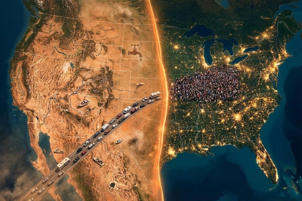


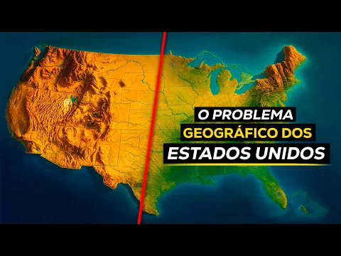
With 80% Of Americans Concentrated East Of Meridian 98, The West Dependent On The Colorado River In Crisis, Water Cuts In California, Nevada, Arizona, And New Mexico Rekindle Climate, Productive, And Social Alerts About Mass Internal Migration And Dispute Over Water Resources In The United States Throughout The 21st Century
In 1878, geologist John Wesley Powell traveled through the interior of the United States and noticed that as he moved from east to west, the landscapes changed dramatically: less vegetation, drier soil, and increasingly rare rainfall. Based on this observation, he drew a first line near Meridian 100 to separate a wetter east from a drier west, a divider that today approaches Meridian 98 and helps explain why about 80% of Americans are squeezed on the eastern side of the country.
According to Congress Gov, throughout the 20th century, especially after the Colorado River Compact of 1922, which divided the river’s flow based on overestimated measurements, western Americans became dependent on a network of reservoirs, aqueducts, and irrigation systems to sustain cities and farms in naturally dry areas. In 2025, in the face of historical declines in Colorado’s levels, the government was forced to impose water cuts in states like California, Nevada, Arizona, and New Mexico, making it even clearer that this invisible line at Meridian 98 is not just a geographical detail but a physical boundary that could push millions of Americans to rethink where and how to live.
The Invisible Line of Meridian 98 That Organizes The Map Of Americans

Precipitation and population density maps show an almost perfect division in the territory: on one side, east of Meridian 98, a country of illuminated cities, large urban areas, and fertile fields; on the other side, westward, long sparsely populated stretches, with few light spots and sections of semi-arid or desert climate.
-
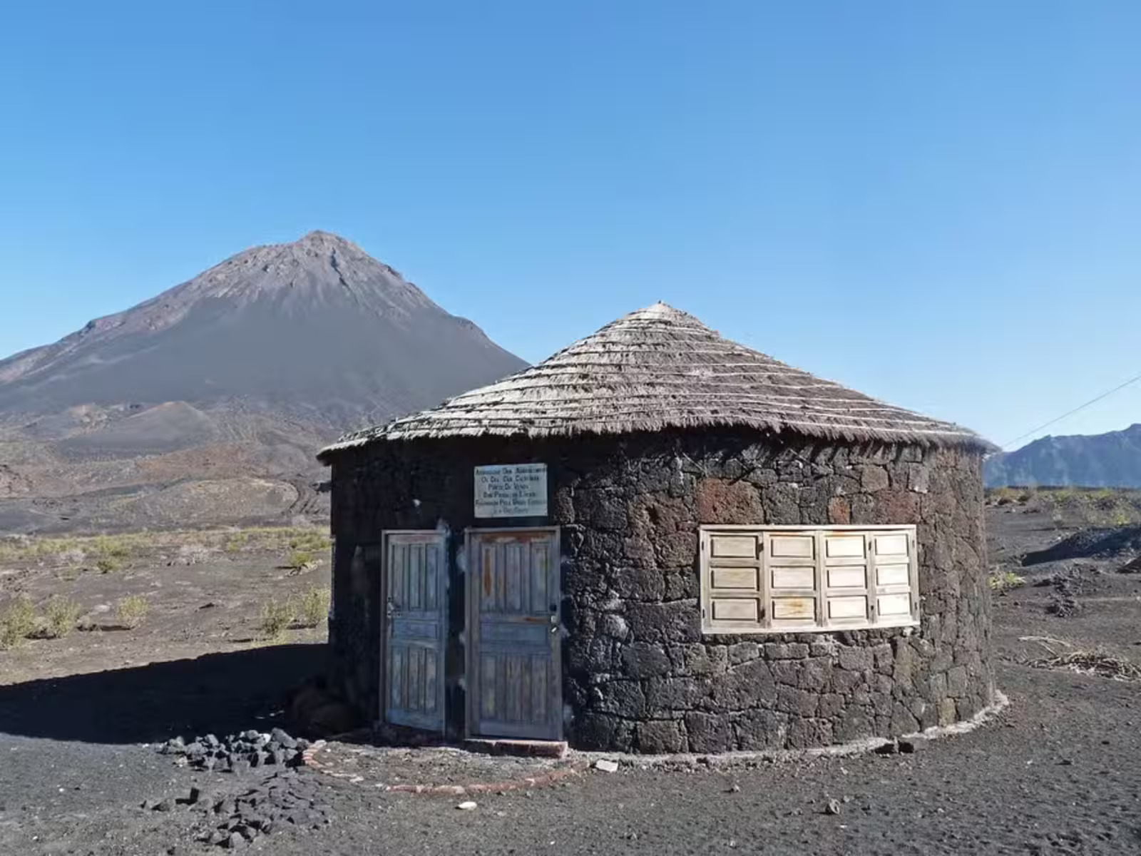
Inside an active volcano in Africa, residents use volcanic rocks to build houses in an impressive setting.
-
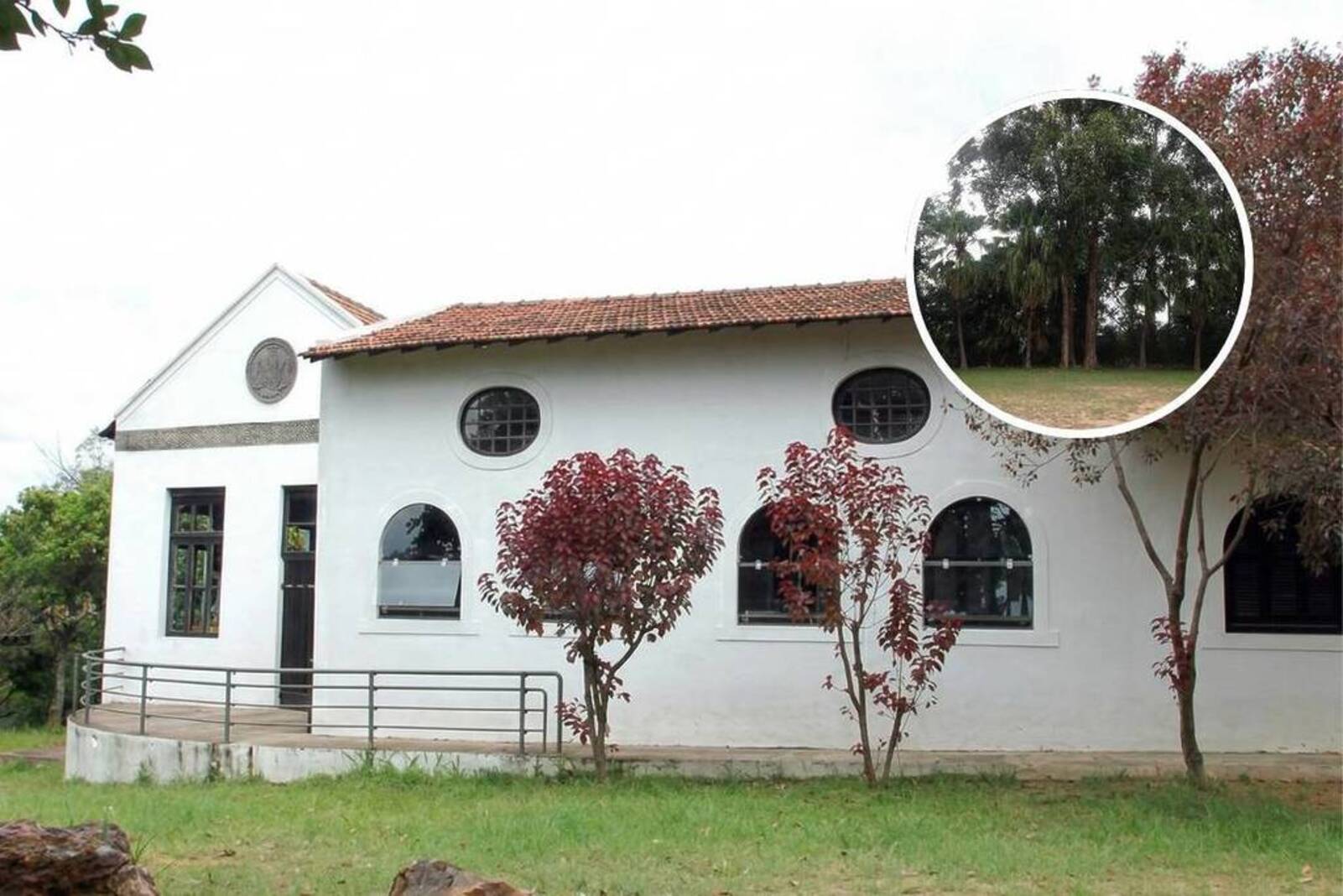
After 14 years of waiting, a rammed earth mansion built in 1702 in the North Zone of São Paulo will become a park with leisure facilities and green areas, with a million-dollar investment.
-
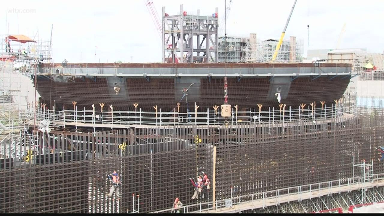
With 2 unfinished nuclear reactors, up to 25 billion in costs, and proven fraud, the Nukegate case has left 800,000 consumers still paying today for energy that will never be produced.
-
The household appliance that consumes the most energy in Brazilian homes is not the air conditioner; it is located in the smallest room of the house, is used daily, and can account for up to 25% of the electricity bill, while an alternative in the same outlet can reduce this cost by up to 75%.


This silent climatic frontier helps explain why four in five Americans live on the wet side of the map, while only 20% occupy the contiguous western sector, not counting Alaska and Hawaii.
The geography itself reinforces this division. Mountain ranges such as the Rocky Mountains, the Sierra Nevada, and the Cascade Range act as barriers that drain moisture coming from the Pacific.
The rain shadow phenomenon causes much of the water to fall before or over the mountains, leaving the interior of the west with few natural sources of freshwater, reliant on less abundant rivers and snowmelt.
For many Americans, this invisible line does not appear on political maps, but silently governs where cities can be built, crops planted, and livelihoods sustained.
Why The East Concentrates 80% Of Americans

In the east, the story is different.
The Mississippi River basin, with its numerous tributaries, comprises one of the largest watersheds on the planet.
With extremely fertile soil, relatively flat topography, and regular rainfall, this region has become the largest continuous stretch of arable land in the world, capable of feeding not only Americans but also external markets through large-scale grain exports. All this with less reliance on complex irrigation systems.
This environment favored the emergence of large urban centers, early industrialization, and robust infrastructure.
Not surprisingly, Americans flocked to areas with the greatest water availability and agricultural productivity, from the so-called Midwest to the Atlantic coastal strip.
At night, the difference is striking: maps of artificial lights display an intensely lit east and a west with large voids, except for California, which alone houses almost half of the population located west of Meridian 98.
American West Trapped By The Colorado River In Water Crisis
On the arid side of the line, the dependence is almost total on a much smaller watershed: the Colorado River, whose capacity is said to be up to 20 times less than that of the Mississippi.
About 40 million Americans rely on this watershed for urban supply, agricultural irrigation, and energy generation, in states ranging from desert interiors to large metropolises.
Cities like Los Angeles, even on the Pacific coast, only established themselves thanks to long aqueducts that draw water from distant regions.
With the advance of climate change, dry air is encroaching on areas that previously had more predictable rainfall patterns.
Agricultural regions near the Meridian 98 line are facing prolonged droughts, and many American producers are already replacing corn with more drought-resistant crops like wheat.
In parallel, the Colorado River is so overdrawn that, at many times, it can no longer reach the Gulf of California, consumed by dams, diversions, and irrigation along the way.
Water Cuts And Disputes Among Western States
In 2025, the worsening crisis imposed a change in course.
To deal with reservoirs at historically low levels, the government had to adopt policies of reductions and cuts in supply in western states, directly affecting the daily lives of millions of Americans living in areas dependent on the Colorado.
The most affected are California, Nevada, Arizona, and New Mexico, all already marked by accelerated urban growth and intense irrigated agricultural activity.
These cuts reignite regional disputes.
The Colorado River Compact, signed in 1922, divided the flow based on a period of measurement that was wetter than the historical average, which overestimated the actual water availability.
Now, with less water entering the system, states are fighting to maintain their contracted volumes, putting even more pressure on a watershed that is already operating at its physical limit.
Every irrigated crop in the desert, every new neighborhood in dry areas adds pressure to a system designed for a climate that no longer exists.
The Ignored Alert From Powell About Water And Limits Of The West
Even in the 19th century, John Wesley Powell already saw the imbalance between the political map and the water map of the west.
He advocated for the borders of new states to be drawn not in arbitrary straight lines, but aligned to watersheds, so that each region would manage its water resources based on natural boundaries.
In Powell’s view, ignoring water would be to ignore the very capacity for sustainable occupation of the territory.
Congress members of the time, however, prioritized the rapid colonization of the west under the Homestead Act model, favoring land speculators and accelerated settlement, without water scarcity being a structuring axis of territorial design.
The result was a development that treated water as an obstacle to be navigated by engineering, rather than an unnegotiable limit.
Decades later, with the 1922 compact based on overestimated flows, Powell’s warning manifests in the growing dispute among states and the extreme dependence on a river that can no longer meet the demand.
The Line That Could Push Millions Of Americans To Move
The big question presented by this invisible line at Meridian 98 is less cartographic and more human.
As drought advances over transition areas and the west remains reliant on a collapsing river, the risk of mass internal migration grows, forced by environmental and economic factors.
Farmers already replacing crops, cities facing expansion limits due to water shortages, and states in legal disputes pave the way for scenarios of relocation of people and productive activities towards wetter areas.
For millions of Americans, this discussion still seems distant, diluted in graphs, precipitation maps, and reservoir reports.
But the combination of 80% of Americans concentrated in the east, a west vulnerable to water collapse, and a Colorado River that no longer reaches the sea transforms the line at Meridian 98 into a potential trigger for demographic reconfiguration.
The looming question is whether the United States will adjust its occupation before water forces, in practice, a major relocation.
In the face of an increasingly dry American west, serial water cuts, and ongoing pressure on the Colorado River, do you think Americans will be able to adapt their cities and farms where they are or will they end up being pushed towards mass internal migration towards wetter regions?


O Deus dos norte-americanos é mamom (o dinheiro). Ajudaram a destruir o meio ambiente deles, enquanto exploravam e ainda exploram países menos desenvolvidos, então que paguem o preço que a natureza está cobrando.
Eles nem precisam se preocupar.
Tem o brasil livre para ocuparem, pois aqui nao há governos, nem povo, nem nacionalismo que possam defender nosso territorio.
É isso mesmo, viva Dudu Bananinha!