 Portuguese
  English
  Spanish
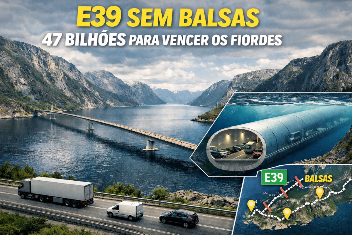


Coastal Mega Project Aims to Transform the E39 Highway, Eliminate Eight Ferry Crossings, Cut Travel Time, and Conquer Deep Fjords with Unprecedented Engineering Solutions.
On the west coast of Norway, the government plans to transform the E39 highway into a continuous link between the south and north of the country, replacing the current ferry crossings with a series of advanced bridges and tunnels. Currently, the route of about 1,100 kilometers takes around 21 hours due to the fjords and mandatory stops, although it could be completed in approximately 14 hours in a straight line.
To change this scenario, the country is implementing the largest infrastructure plan in its history, estimated at $47 billion. More than just shortening travel time, the project plans to transform the highway into a modern transportation corridor capable of integrating isolated communities, facilitating the flow of goods, and creating a new global showcase for Norwegian engineering.
The Fjord Coast and the Challenge of the E39
The so-called E39 coastal highway snakes along the country’s shoreline, a region known for housing some of the most stunning landscapes on the planet, with over a thousand fjords formed by ancient glaciers.
-
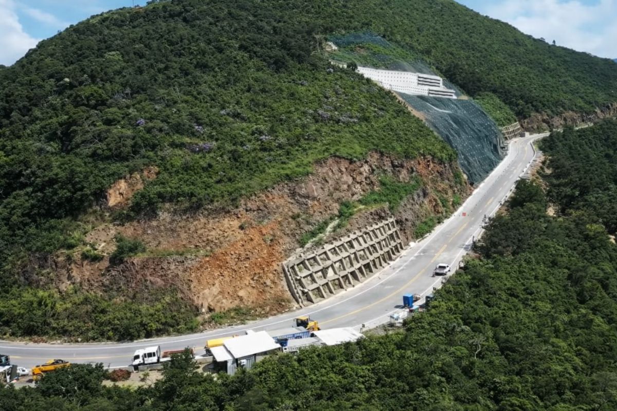
The section of Serra da Rocinha on BR-285 is now open in Timbé do Sul: 50 m tensioned curtains and top-down technique stabilize the slope, with a stairway duct controlling the water.
-
Scientists use sawdust mixed with clay to create a lighter brick, promising efficient thermal insulation and impressing by transforming waste into a solution for construction.

-
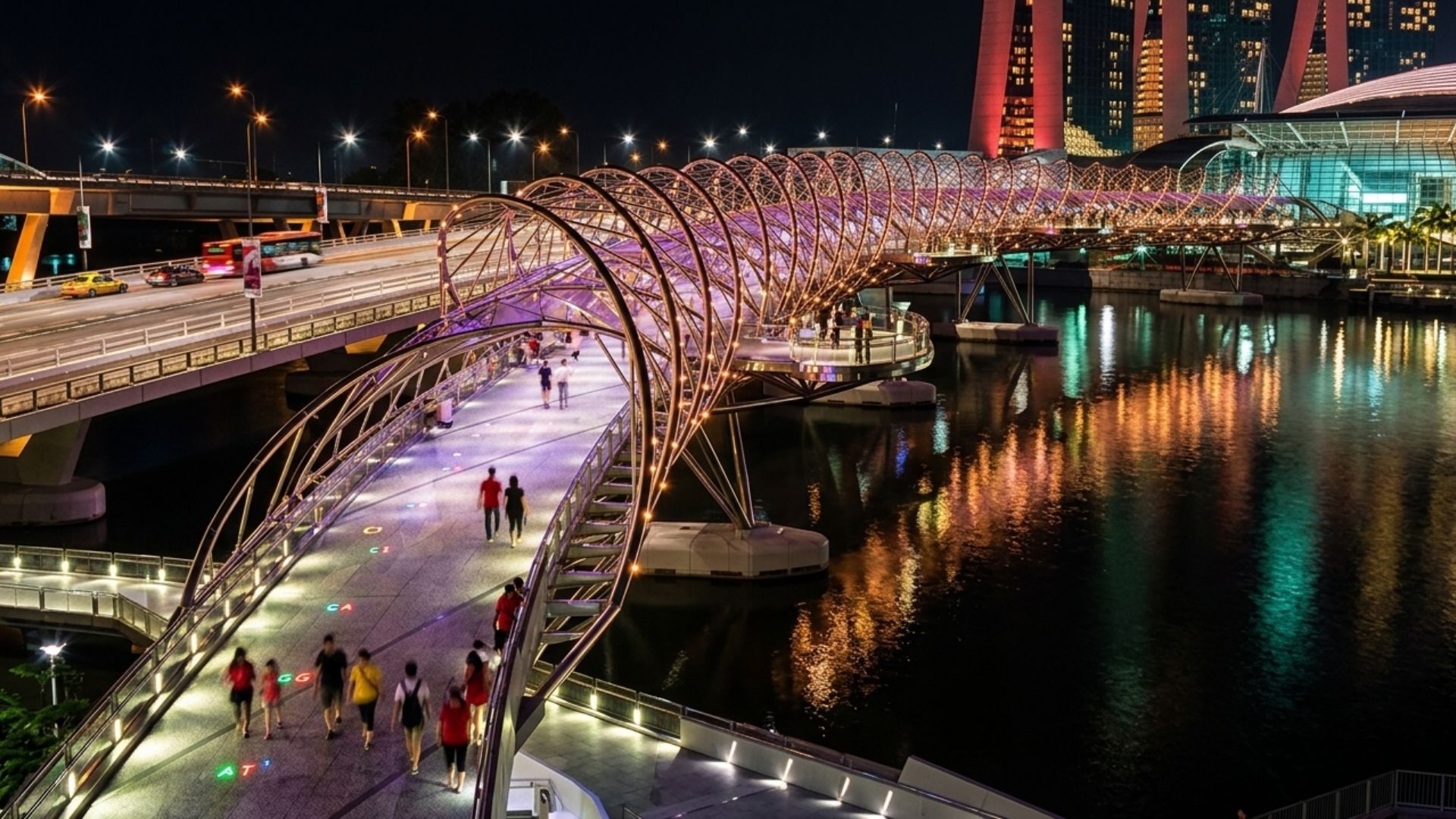
With a DNA shape, this bridge in Singapore draws attention in modern architecture and surprises tourists by transforming a simple crossing into an unforgettable visual experience in the urban heart.
-
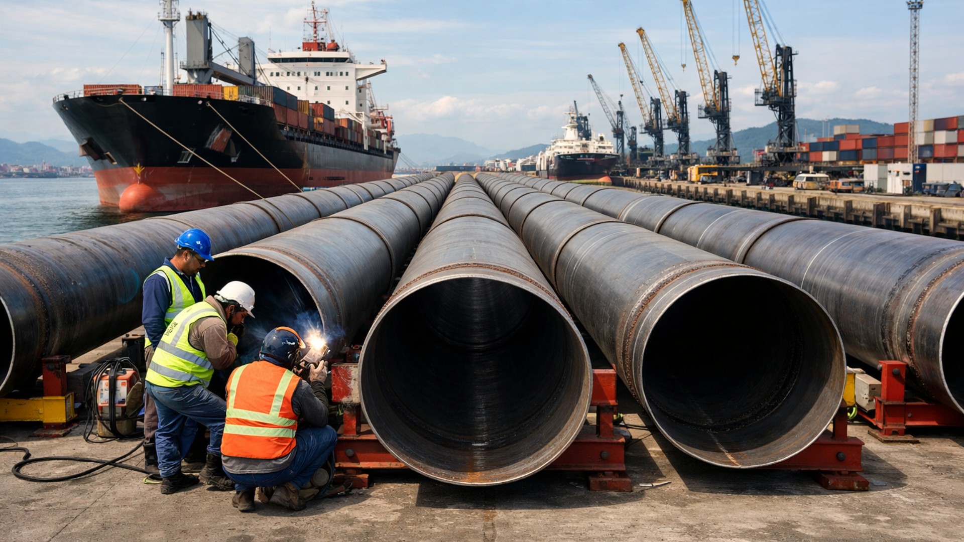
Giant underwater pipeline begins to take shape with a R$ 134.7 million project at the Port of Santos: the 1.7 km structure uses 12-meter and 700 mm pipes to supply water to 450,000 people in Guarujá.

The largest of them measures about 200 kilometers in length and over 1 kilometer in depth, making any crossing project an extreme challenge.
Along the current route, between the southern and northern extremes of Norway, the E39 crosses several fjords and currently relies on eight ferry crossings. Each stop represents waiting, boarding, and disembarking, adding hours to the trip and creating vulnerability in case of bad weather, queues, or operational interruptions. The government plan aims to transform the highway to completely eliminate these ferries and ensure a continuous flow of vehicles.
Rogfast: The Submarine Tunnel That Ushers in a New Era

The first major step of the project is Rogfast, a submarine tunnel that will connect the E39 to the Stavanger region. It will span about 27 kilometers in length, in a section that may reach 390 meters in depth, which should make it the deepest road tunnel and one of the largest in the world when completed.
Rogfast will consist of two parallel tunnels, with connection accesses every 250 meters and emergency exits every 500 meters, in addition to shoulders and security cameras along the entire route. Along the way, the structure will also connect to a small archipelago of about 5 km², integrating islands and just over 500 inhabitants into the rest of the country, emphasizing how the government plans to transform the highway into a tool for regional inclusion as well.
Construction of Rogfast began in 2018, was halted in 2019 for project review, and resumed in 2021, with an expected completion by 2026 and an estimated cost of $2 billion.
Floating Bridges and Sunken Tunnels to Overcome Giant Fjords

If Rogfast is already impressive, other sections of the plan require even bolder solutions. South of a major coastal city, a fjord with up to 10 kilometers in width, stretches of 5 kilometers, and a depth of about 600 meters challenge any conventional structure. For it, engineers are studying a floating bridge anchored to the shores, capable of adapting to the extreme depths and maritime conditions.
In another crossing over the Sula Fjord, two ideas are on the table. The first is a suspended bridge with three towers in sequence, with one anchored to the seabed about 400 meters below the waterline and the other two connected to the coast. The alternative is a floating and submerged tunnel with two parallel tubes, suspended by highly resistant cables anchored to the bed of the fjord, allowing ships to pass on the surface without interrupting vehicle traffic.
Another planned section requires an underwater tunnel of about 16 kilometers, also complemented by a bridge of approximately 2 kilometers in length, creating a combination of structures to overcome depths and widths that vary depending on each fjord. In all these solutions, the goal is the same: plans to transform the highway into a continuous route, even where geography seemed to prevent any direct connection.
The Largest Fjord and the Most Ambitious Part of the Project

The most complex point of the plan lies in the crossing of the largest and deepest fjord in Norway and Europe, stretching more than 200 kilometers in length, about 3.7 kilometers wide, and 1.3 kilometers deep at its deepest point. The region also receives heavy ship traffic, which obliges engineers to foresee minimum clear spans of 400 meters in width, 70 meters above the water, and at least 20 meters below for safe passage of vessels.
For this section, several alternatives are being analyzed. One of them is a suspended bridge approximately 3,700 meters in length, almost double the length of the longest current bridge in the world, which would require towers nearly 500 meters tall. Another option is a floating bridge, which would need movable or adjustable parts whenever large ships approached, adding enormous operational complexity.
There are also studies for a floating and submerged tunnel without cables anchored to the bottom, supported by floating blocks on the surface, allowing ships to cross above without interfering with the structure. A hybrid solution combining a floating bridge with a submerged tunnel is also under evaluation. This type of transition between emerged and submerged structures already exists in connections like the bridge between Denmark and Sweden and the crossing between Hong Kong and Macau, but never in such a deep and complex scenario as this.
World-Class Reference in Engineering and Infrastructure
Although other countries like Italy, the United States, and Japan have considered projects to link areas of rugged terrain, none has progressed as far as the Norwegian plan for its fjord coast. The works associated with the E39 are making progress and are expected to extend until around 2035, when the government hopes to have the route fully connected.
The $47 billion investment is expected to be recovered primarily through tolls along the new coastal route. Meanwhile, engineering teams are working with strong environmental and safety concerns, planning structures that can withstand strong winds, currents, heavy ship traffic, and the harsh conditions of the North Sea. The ambition is that the project plans to transform the highway not only into a faster road but into a global model of infrastructure for extreme regions.
In the end, the new E39 promises to shorten distances, bring cities closer together, integrate islands, and show the world that it is possible to combine untouched landscapes with some of the most ambitious engineering solutions ever conceived.
And you, do you believe it is worth investing all this in a project that plans to transform the E39 highway into one of the most impressive routes on the planet, or do you think there are simpler and cheaper alternatives to improve mobility in the region?


Ninguém pensou no espaço aéreo?
Ninguém pensou no espaço aéreo????