 English
  Francês
  Alemão
  Italiano
  Japonês
  Norueguês
  Portuguese
  Spanish
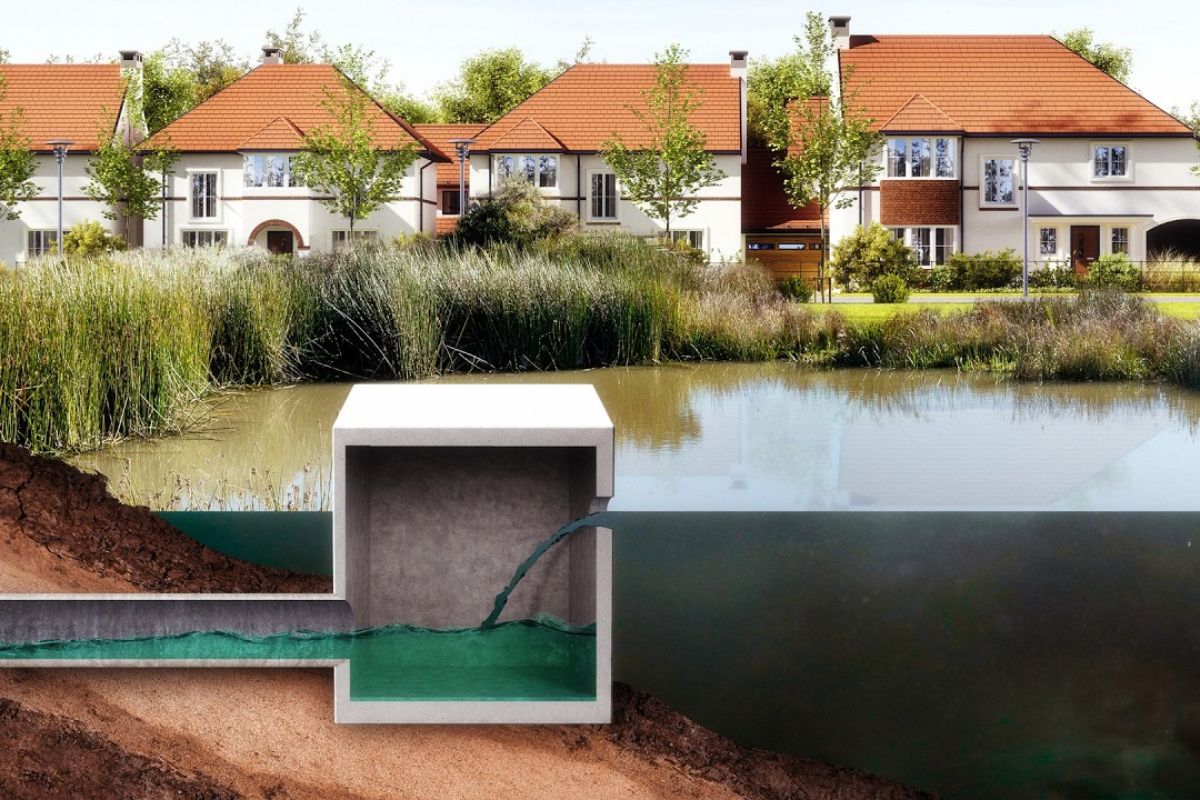


Instead Of Just Decorative Lakes, Retention Ponds Became Safety Valves For Cities, Controlling The Peak Of Rain, Holding Pollutant Sediments And Opening An Urgent Discussion About Design, Operation, Maintenance Failures, And Regional Solutions For Urban Drainage In Old Neighborhoods, New Developments And Parks
Retention ponds arose to solve a very simple yet structural problem: when the city is covered with roofs, asphalt and concrete, rainwater stops infiltrating the soil and starts running quickly to galleries, streams, and rivers. The result, during heavy rain episodes, is a flow peak that is much higher than what existed before urbanization, increasing the frequency and severity of floods in already consolidated areas. In neighborhoods like the Fourth Ward in Atlanta, this accumulation of surface runoff turned recurring floods into a critical safety and infrastructure issue.
In this scenario, the classic solution would be to enlarge pipes, open channels, and build large underground drainage tunnels. In Atlanta, such a project was designed, with a deep tunnel to carry rainwater away. But municipal engineers proposed another path: create a park with a central lake, technically designed as a stormwater reservoir. Thus, an area with a history of flooding gains an urban facility with lawns, a playground, an amphitheater, and a water mirror, while the lake, beneath the landscape, takes on the function of dampening floods and modulating the behavior of the regional drainage system.
How Retention Ponds Fit Into City Design

When a natural land is divided into lots, a radical change in hydrological behavior occurs. Before, the soil absorbed a considerable part of the rain; the water infiltrated, recharged aquifers, and drained more slowly into watercourses.
-
The climate in 2026 may surprise with extremes even more intense than in 2025, with heatwaves, out-of-season cold, and irregular rainfall in Brazil.

-
Astronomers identify 45 rocky planets that could harbor life, and one of them is just 4.2 light-years from Earth, making it the closest neighbor with the potential to have liquid water on its surface.

-
Archaeologists discover 43,000 ostraca in Egypt with tax lists, drawings, religious texts, and everyday notes that reveal what life was like in ancient Athribis before Cleopatra.

-
China showcases laser defense systems that target drones flying very low and attempts to address a flaw that has been concerning armies worldwide.


After urbanization, the same lot now has paved streets, parking lots, roofs, sidewalks, and continuous impermeable areas. Almost all the rain that falls on these surfaces becomes immediate surface runoff, converging to an exit point connected to the public network.
For this reason, many municipalities have begun to require, as a condition for construction permits, that the peak discharge of an urbanized lot does not exceed the peak that existed before the development.
In practice, this forces developers and designers to reserve volume to store part of the rainwater and release it gradually.
The retention ponds are the physical translation of this requirement: excavated reservoirs, usually open to the sky, that receive water from roofs and pavements, temporarily hold the runoff, and return it in a controlled manner to the drainage network, through calibrated outlet structures.
From Flood To Urban Reservoir: What Retention Ponds Do

The principle of operation is straightforward. Instead of letting all the rainwater run at once to galleries and rivers, the basin receives the flow, accumulates volume, and releases only a fraction, keeping the outflow below a limit defined in the project.
Didactic tests with scaled models clearly show the effect: the input graph during a typical storm appears as a “bell” with a sharp peak; the outflow graph from the pond is lower and longer, with the same total volume, but distributed over a longer time.
This difference in peak is what separates a manageable flood from a severe inundation. The height that the water reaches downstream is directly related to the maximum flow, not just to the total volume.
By “trimming” this peak, retention ponds function as hydraulic buffers, protecting neighborhoods located at lower elevations in the basin.
Instead of multiple runoff fronts arriving together at the same stream, the drainage systems start to receive diluted inputs, within the passage capacity of the existing channels.
Flood Control, Residence Time, And Water Quality

If the goal were merely to reduce the peak discharge, a detention basin that empties completely after the rain would suffice. But experience in large cities has shown that surface runoff carries more than just water.
Fine trash, street sand, tire remnants, oil, animal feces, de-icing salt, and other pollutants that adhere to sediments end up being transported directly to streams and rivers.
Therefore, many projects have gone beyond simple detention and adopted retention ponds with a permanent water mirror, designed also for basic quality treatment.
When there is a minimum constant volume, the newly arriving water, laden with particles, comes into contact with a body that is either already stationary or moving slowly.
The turbulence dissipates as the flow advances toward the exit, and suspended solids have time to settle at the bottom. Pollutants associated with sediments tend to be retained in the reservoir, reducing the load that reaches the receiving watercourse.
The difference between the first drops of rain, responsible for what is called the “first flush” (which is dirtier), and the remainder of the event starts to be absorbed by the pond, which acts as a distributed settling tank in the landscape.
Smart Retention Ponds And The Use Of Adaptive Control
The next step in this evolution is to transform static structures into active systems. Instead of relying solely on fixed orifices and spillways, some cities are already testing outlets controlled by sensors and automation.
In these cases, retention ponds start to operate with continuous monitoring and adaptive control, adjusting the discharge rate according to water level, weather forecasts, and downstream conditions.
In practice, this allows retaining water for longer during dry periods, favoring sedimentation and, in some cases, local aquifer recharge, and emptying part of the volume proactively before a heavy rain front, recovering useful space to dampen the next peak runoff.
This logic expands the hydraulic potential of the same structure but comes at a cost in complexity: it is necessary to ensure energy, communication, remote operation, and a permanent maintenance plan for valves, sensors, and equipment, at the risk of the solution becoming a new point of failure in the system.
Local Detention, Regional Basins, And The Chain Effect
Not all drainage can be solved within the limits of an individual lot. In many urban centers, multiplying small reservoirs on each lot has generated unexpected consequences.
Each basin reduces and delays the peak of local runoff, but if several structures are designed with similar detention times, the smoothed peaks can end up reaching the same stream almost simultaneously.
The result is a “chorus” of overlapping discharges that, when summed up, raises the flood level beyond expected in critical sections of the watershed.
For this reason, many planners have begun to discuss regional urban drainage solutions, with large retention ponds downstream fed by multiple developments.
In these arrangements, the city accepts that not all lots have complete on-site structures, provided they financially contribute to shared systems designed on a watershed scale.
A single well-positioned installation, with robust volume and professional operation, can provide more consistent flood control and water quality than dozens of small reservoirs without periodic inspection.
Climate, Geology, And Specific Solutions For Each Region
Retention ponds are not a universal answer. Climatic conditions, soil type, and aquifer vulnerability define limits and adaptations.
In areas with outcropping limestone, like the Edwards Aquifer region around Austin, the fast connection between surface and groundwater requires extra care regarding groundwater contamination.
In such cases, alternatives like filtration ponds with sand beds emerge, forcing the water to pass through filtering layers before being discharged into watercourses, reducing the load of soluble pollutants and fine particles.
In other contexts, permeable pavements, rain gardens, green roofs, and infiltration trenches are combined with larger reservoirs, creating hybrid systems.
The logic is to spread part of the retention at the source, close to the impermeable surface, and concentrate another part in larger structures, coordinated by drainage agencies.
This mosaic of solutions shows that the pond is not an end in itself but one of the components of a broad arrangement that needs to be adjusted for rainfall regimes, urban occupancy, and the capacity of the city to operate.
Maintenance, Risk, And The Question Of Who Takes Care Of The Infrastructure
As retention ponds multiply, they raise a recurring question among residents, technicians, and managers: who is responsible for inspecting, desilting, cleaning vegetation, and monitoring outlet structures over the years?
Forgotten reservoirs can lose useful volume due to sediment accumulation, have clogged outlets, and become points of risk during an extreme event.
The same structure that should reduce floods can, if neglected, worsen localized flooding or create sanitary problems.
On the other hand, positive experiences with floodable parks, like Atlanta’s, indicate that integrating hydraulic function with everyday use helps keep the infrastructure visible and politically relevant.
When the pond is just a hole surrounded by a fence, far from public view, the pressure for maintenance tends to be lower.
When it becomes a recreational space, with trails, lawns, and equipment, the community recognizes the importance of that volume of water and demands answers during periods of heavy rain.
What Cities Can Learn From Their Ponds
The spread of retention ponds marks a quiet change in how cities deal with rainwater.
Instead of merely trying to expel runoff as quickly as possible through tunnels and channels, planners have begun to accept that part of the solution lies in slowing down the flow, storing critical volumes, and treating, even partially, the pollution that would otherwise flow freely into rivers and streams.
The hydraulic infrastructure, once invisible, is starting to occupy the centers of plazas and parks, serving both as a safety system and a landscape.
The efficiency of these structures, however, depends on decisions made far beyond the engineering of each individual basin.
Design parameters, operation models, maintenance plans, and choices between local or regional detention determine whether these reservoirs will be long-lasting allies against floods or just another vulnerable point in urban drainage.
In a scenario of more intense rains and growing occupancy, the way each city responds to these issues tends to decide the future of its rivers and lower neighborhoods.
In light of this, one question remains for those living in flood-prone areas: in your city, are the ponds and parks that hold rainwater seen as mere scenic landscapes or as central pieces of a protection system that you keep track of, question, and demand be well maintained?


Maluf começou com isso na década de 1980 em são Paulo, com os picinões, coisa não observada na matéria, não deveria ser ignorada!!
Fizeram algo assim na AV. Heráclito Graça em Fortaleza. Um grande reservatório pra escoamento da água sob a via. A priori funcionou perfeitamente, evitando os tradicionais alagamentos na área citada. Resta aguardar se o equipamento vai receber a manutenção adequada. Mas já vi equipes fazendo a limpeza da imensa galeria, por um acesso em uma praça próxima.