 Portuguese
  English
  Spanish
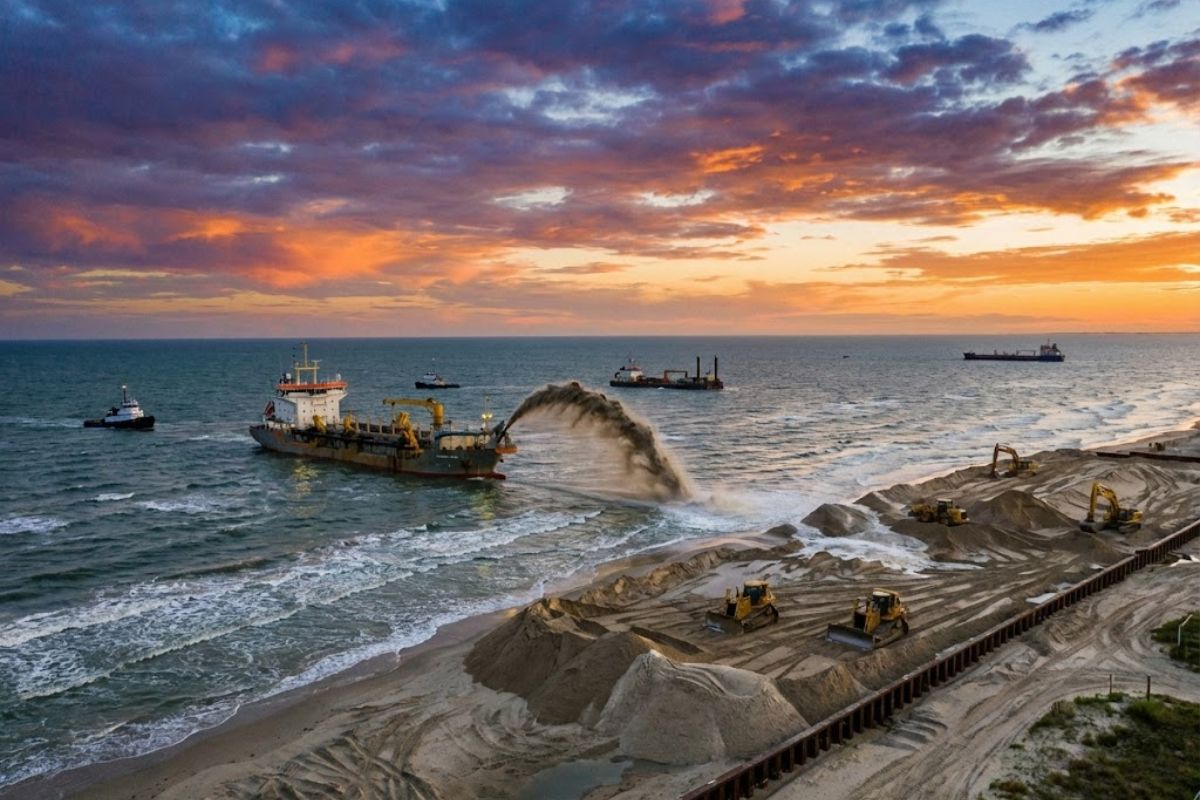
The dredged sand from the Galveston Navigation Channel is being reused to feed the shore between Sunbather Lane and 11 Mile Road. With 717 thousand cubic yards expected, the US$ 23 million package seeks to contain an average erosion of almost 2 meters per year and buffer storms on the island.
The sand has become the central input of a coastal reconstruction operation in Galveston, Texas, in the Gulf of Mexico: dredges remove material from the Galveston Navigation Channel and deposit it on West Beach to recover a stretch of coastline that has been losing ground to the sea.
The intervention targets an area defined by a feasibility study and covers the stretch between Sunbather Lane and 11 Mile Road, with staggered deliveries between September and the end of January or early February 2026, raising the level of protection against tropical storms and hurricanes.
Where the Sand Is Being Placed and Which Section Enters the Map

The replenishment is occurring on West Beach of Galveston Island, with deposition along 2.9 kilometers of shoreline, from the landmark Sunbather Lane to 11 Mile Road.
-
With a cost per shot close to zero, the DragonFire laser could change naval warfare in 2027 and provide British ships with nearly unlimited defense against drones.

-
A British startup creates tires that generate electricity in electric vehicles when passing over potholes, speed bumps, and cracks.

-
Scientists have created robots made with living cells that have their own nervous system, swim on their own, explore the environment, and self-organize without any genetic engineering, and now they want to do the same with human cells.

-
Students create a solar-powered ambulance that operates without a plug, without fuel, and still keeps medical equipment running in remote areas.


The operation is designed to specifically reinforce the western end, which has been identified as the most impacted, where coastal erosion has been described as nearly 2 meters per year.
In addition to the main deposition corridor, the project communication also mentions West Beach receiving nearly 3.2 kilometers of reinforcement along the coast, indicating a replenishment plan distributed over a wide arc, aligned with the goal of protecting the Texas coast against erosion and tropical storms.
Who Is Behind the Project and How the Partnership Was Formed

The project brings together multiple fronts on the island and in the state: the Texas General Land Office, the Galveston District of the U.S. Army Corps of Engineers, the city of Galveston, and the Galveston Park Board of Trustees.
The logic is to unite coastal management, dredging execution, and local coordination, with a unique design to expedite the replenishment.
During a visit to West Beach on November 21, 2025, details of the work were presented to students of Texas A&M University, with explanations from project manager Carlos Tate, of the Galveston District, reinforcing the operational and educational nature of the fieldwork.
Where the Sand Comes From and Why the Material Changed Destination

The sand used is dredged from the Galveston Navigation Channel by the U.S. Army Corps of Engineers, Galveston District.
This material is part of the channel’s maintenance routines and, under standard flow, would have been discarded in an offshore disposal area.
The project changes this destination: by replenishing the beach with the dredged material, the sand now serves as a physical reinforcement of the coastline, strengthening the shoreline against erosion and the impacts of storms, in addition to protecting coastal properties and habitats on the island.
The Size of the Operation in Numbers and the Goal for 2026
The scale is addressed in volume and timeframe.
Authorities indicated that over 90 thousand cubic yards of quality beach sand had recently been added to West Beach, and that “more sand is on the way” as part of a larger effort in Texas.
To complete the main phase, about 717 thousand cubic yards of dredged material are expected to be deposited along the coast, with work beginning in September and final delivery expected by the end of January or early February 2026.
The timeline places the replenishment in the critical window before the peak of the storm cycle, when sand loss tends to accelerate.
Why the Erosion of Almost 2 Meters Per Year Became the Trigger for the Plan
The diagnosis guiding the intervention is straightforward: average coastal erosion on the island has been indicated as nearly 2 meters per year, with a greater impact on the western end.
This continuous loss shortens the beach width, exposes structures, and reduces the natural capacity of the shore to dissipate wave energy.
The response is literally to increase the available “stock” on the front line.
The more sand exists on the beachfront property, the greater the protection tends to be, because the beach functions as a physical buffer, absorbing the impact that, without this cushion, would go directly to the urban edge and the natural coastal system.
Hurricanes, Tropical Storms, and the Logic of Buffering
The risk is not abstract: the coast of Galveston is described as vulnerable if a hurricane or tropical storm strikes the island.
From the operational reading of the project, storms and hurricanes inevitably carry sand back to the ocean, but the aim is for this loss to occur from a reinforced area, reducing the severity of the impact.
The strategy is based on a principle of coastal protection: the replenishment expands the beach, slows the encroachment of the sea on sensitive areas, and creates a more robust barrier between the force of the waves and the interior of the island.
The sand becomes a consumable defense, designed to be sacrificed in extreme events instead of streets, homes, public equipment, and habitats.
How Much It Costs, Who Pays, and How the Funding Was Structured
The total cost was estimated at about US$ 23 million.
The funding combines federal funds through the Continuing Authorities Program, Section 204, and a grant of US$ 13 million from the Texas General Land Office.
In practice, this structures a project with hybrid funding: federal resources anchor the large-scale execution and maintenance of the channel that supplies the material, while state funding supports the local protection of a specific stretch of the island that concentrates erosion and vulnerability to storms.
What Changes Now for West Beach of Galveston
With deposition expected by the end of January or early February 2026, West Beach enters a phase of consolidating the new coastal profile, with a wider stretch and material repositioned along the defined section.
The expectation is that the protection translates into less shoreline retreat, greater resilience to storms, and maintenance of coastal habitats.
The operation also redefines the destination of the dredged canal material: instead of disposal offshore, the sand is treated as a coastal asset, aligning navigation maintenance with beach protection and damage reduction on the island.
Do you think using dredged sand to rebuild beaches should become standard in other coastal cities that lose several meters of coastline per year, or does each region need a completely different model?


-

-

2 pessoas reagiram a isso.