 Portuguese
  English
  Spanish
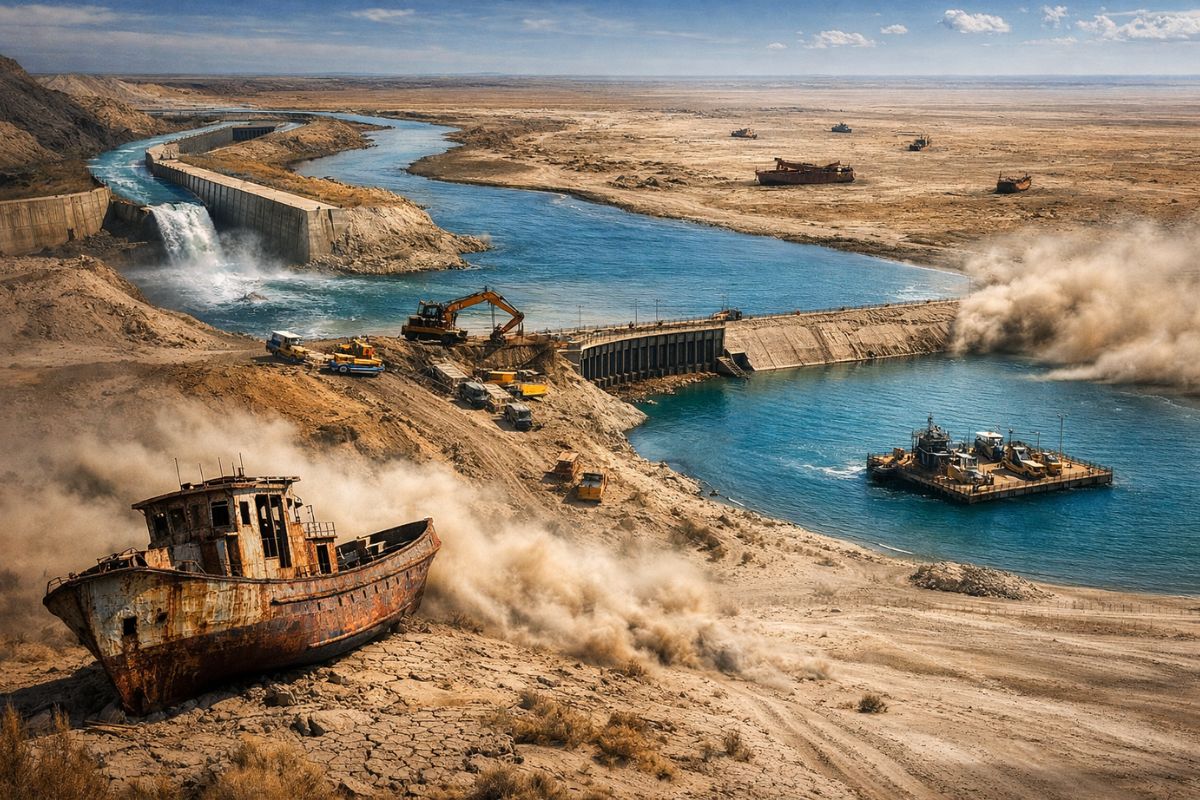
Between Kazakhstan and Uzbekistan, the Former Aral Sea Became a Brutal Laboratory of Environmental Collapse After Giant Rivers Were Diverted for Soviet Irrigation, Increasing Salinity, Destroying Fishing, and Spreading Contaminated Dust, While the North Tries to Reborn with Dam and the South Learns to Survive Without a Sea Definitively.
The giant rivers that fed the Aral Sea sustained for millennia a rare balance in a desert basin with no connection to any ocean. The Sier Daria came from the north, the Amu Daria flowed down from the south, and it was this constant replenishment that kept alive a sea that, in 1960, stored about 1 trillion cubic meters of water.
The collapse did not come from a bomb or direct drainage. It came from diversion. By withdrawing the water that these rivers brought to the basin, the Soviet Union transformed a stable system into a progressive disaster, and what we see today is a partial recovery in the north and an almost definitive sentence in the south. The Aral Sea has not returned entirely, and all indications are that it never will.
The Sea Was Not Abundant, It Was Balanced

The Aral Sea always lived on the edge. Located between Kazakhstan and Uzbekistan, in an area of intense evaporation, little rain, and extreme temperatures, it depended entirely on the continuous influx of water.
-
Scientists transform sawdust into fire-resistant panels, stabilize the compound with an enzyme extracted from watermelon seeds, and turn waste into promising material for construction.

-
Forget concrete: architects are replacing tons of concrete with giant blocks of expanded polystyrene to build the roofs of houses and reduce structural weight by up to 50%, cut costs, improve thermal insulation, and speed up construction.

-
The Brazilian state enters the center of the global race for critical minerals by starting the construction of the largest underground nickel mine in Latin America, a mineral essential for electric car batteries that the entire world is competing for at this moment.

-
New CCR concrete paving technology promises roads up to 3x more durable, less maintenance, and cost reduction in Brazil.

At some points, the annual loss due to evaporation could exceed 1.5 meters per year, which shows that the existence of the sea was not guaranteed by excess but by permanent replenishment.
This detail helps to understand why the collapse was so rapid when the logic of the region changed. The sea did not survive for thousands of years because it was too deep or too large to dry.
It survived because the giant rivers that supplied it compensated for what the climate constantly removed. When this compensation was broken, geography began to charge the price.
At its peak, in 1960, the Aral covered about 26,000 square miles, an area comparable to a sea the size of Ireland. It supported fishing communities, moderated the local climate, and functioned as the centerpiece of a human and environmental landscape that seemed permanent.
However, this permanence depended on a flow that, decades later, would be treated as a transferable resource.
The change was decisive because the water that maintained the sea did not come from the basin itself. It came from afar, fed by melting snow in mountainous regions. This means that the Aral was, from the beginning, an effect of regional water circulation.
Cutting this flow was not about reducing a detail: it was attacking the very condition of the sea’s existence.
Soviet Cotton Dried What Could Not Be Replaced

The turning point began in the 1960s, when the Soviet Union decided to transform Central Asia into a global cotton power.
The project, called “white gold,” required a massive expansion of irrigation, with canals spreading across the region like an artificial mesh. The most symbolic example was the Karakhum Canal, over 850 kilometers long.
The logic was simple and devastating. Water from the Sier Daria and Amu Daria began to be diverted to agricultural fields hundreds of kilometers away. Every drop sent to production was one less drop reaching the Aral Sea.
They did not empty the sea by taking its water from within; they emptied it by stealing the water that should have reached it.
The consequences came quickly. The water level fell, salinity skyrocketed, reaching about three times that of regular seawater.
Fish populations collapsed, commercial fishing disappeared, and ports became isolated in dry land. What was once a shore became distance.
The exposed seabed further aggravated the tragedy. Contaminated by salt and agricultural chemicals, it became a source of toxic dust.
Storms carried this material for hundreds of kilometers, spreading contaminated sediments and helping to trigger respiratory crises in nearby communities.
The disaster ceased to be just a water issue and also became a public health and atmospheric problem.
When the Aral Split, Two Incompatible Futures Were Born
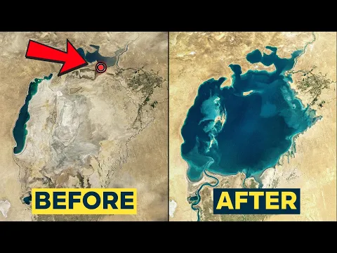
In the 1990s, the Aral Sea fragmented into separate basins. This moment was decisive because it revealed that the problem was not singular.
The north, fed by the Sier Daria, was smaller, shallower, and, primarily, closer to the water source itself.
The south, dependent on the distant Amu Daria, was vast, extremely shallow, and situated in one of the most evaporative environments on Earth.
This difference made recovery unequal from the start. In the north, since the required volume was smaller, there was still room for retention and partial recomposition.
In the south, the math became nearly impossible. Restoring the water would require a replenishment scale that simply no longer existed, as the upstream economies had been built on the continual diversion of these giant rivers.
Kazakhstan, which controls the north, saw this as a concrete opportunity. If it could hold enough water, it could raise levels, reduce salinity, and bring fishing back.
Uzbekistan, with the southern basin in collapse, reached another conclusion: trying to restore that entire sea no longer made operational or economic sense. Faced with the same tragedy, each side chose an opposite response.
It was then that the crisis ceased to be just a story of environmental destruction and also became a story of political decision-making.
Kazakhstan bet on selective recovery. Uzbekistan decided to manage the permanent consequences of an almost irreversible loss. The north became a laboratory of engineering. The south became a territory of adaptation.
The Dam That Made the Water Rise and Fishing Return
The Kazakh solution was as straightforward as it was symbolic: to build a barrier. In 2005, the country completed the Kokaral Dam, a concrete structure erected at a narrow stretch of about eight miles that once connected the northern and southern basins.
The idea was to prevent water from the north from escaping to an area too large and too shallow to be efficiently refilled.
The result was quick. In just one year, the water level in the north rose eight meters. Salinity dropped, species of fish that had disappeared began to return, and cities that had spent decades watching the sea recede were able to observe the waterline advancing again, in some cases by kilometers in a single season.
For the first time in decades, the Aral Sea ceased to shrink and began to grow in one part of the map.
Fishing, which seemed dead for a generation, returned to provide employment and economic horizon. Flounder and perch reappeared after being repopulated from other lakes.
The impact did not mean a full restoration, but it was enough to prove that the north could still respond to a correct intervention.
Even so, the scope of recovery is limited. Kazakhstan aims to further raise the dam and modernize irrigation to save 500 million cubic meters per year, targeting 34 billion cubic meters by 2030.
If all goes well, the projection is to restore the northern sea to just 5% of its original size by the 2030s. It is a real victory, but also a brutal measure of how much has been lost.
The South Died as a Sea and Survives as a Landscape of Crisis
If the north can be reborn on a small scale, the south has already been treated differently. Uzbekistan abandoned the idea of refilling the southern basin and began working on dust control, land recovery, and water infrastructure for the communities that remained.
Instead of restoration, the keyword became disaster management.
This change is tough because it is part of an almost definitive acceptance: the south will not return to being a sea.
The Amu Daria today supplies about 4 million hectares of cotton fields, and redirecting this water would mean imploding the economic foundation that has consolidated over decades.
What destroyed the Aral also became what sustains part of the regional economy, and this paradox blocks any large-scale return.
Therefore, the Uzbek adaptation is less grandiose in discourse but more honest in math. Instead of selling the promise of a total reversal, the country tries to make habitable what remains.
The problem is that surviving the disaster does not replace what has disappeared. It does not bring back fishing, does not restore climate moderation, and does not erase the contaminated seabed that continues to feed toxic dust.
It is a solution of containment, not redemption. And it only works if the region accepts that the south of the Aral has ceased to be a sea and has become something else: a new landscape shaped by human decisions, water scarcity, and the limits of reversibility.
The sea was replaced by a void that needs to be managed.
The Siberian Megaproject Stayed on Paper and Will Probably Die There
There was an even more radical proposal: to seek water from outside the region. The old Soviet plan envisaged a 2,200-kilometer canal to divert about 60 cubic kilometers per year from the Ob and Irtysh rivers in Siberia and refill both basins completely in 20 to 30 years. In theory, it would be the only way to think about complete recovery.
In practice, the cost was enormous. The project would require 3 gigawatts of continuous pumping, alter the salinity of the Arctic Ocean, and flood vast areas of peat swamps. Worse: politically, it lost meaning.
Cancelled in 1986, this plan became even more improbable because China now controls a significant part of the Irtysh River upstream. Engineering could be imagined; geopolitics buried the execution.
This narrows the alternatives to three real paths: limited recovery in the north, permanent adaptation in the south, or insistence on a megaproject that is unlikely to materialize.
Kazakhstan chose to retain water. Uzbekistan chose to survive the desert that was born in place of the sea. The Siberian project remains a ghost of a scale that is no longer politically viable.
In the end, this combination defines the fate of the Aral. The north is proof that extreme environmental damage can be partially reversed.
The south is proof that not all catastrophes can be undone, even with money and political will.
Between the two, the Aral Sea became a lesson about what humanity can destroy and about how little it can rebuild afterward.
The Aral Sea did not disappear due to a climatic accident or a sudden drought.
It was drained when giant rivers that sustained a desert basin began to be used to irrigate a cotton economy built without considering the final cost.
The collapse transformed water into salt, seabed into toxic dust, and fishing cities into geographic memories.
Today, what exists is a divided map. The north rises, returns to having fish, and gives Kazakhstan some argument to talk about recovery.
The south sinks in the logic of adaptation and confirms that certain damages go beyond a point of no return.
If you had to choose between investing billions to recover only a fraction of what remains or accept once and for all that the south died as a sea, which decision would seem more honest in light of the real extent of the destruction?


-

-

2 pessoas reagiram a isso.