 Portuguese
  English
  Spanish
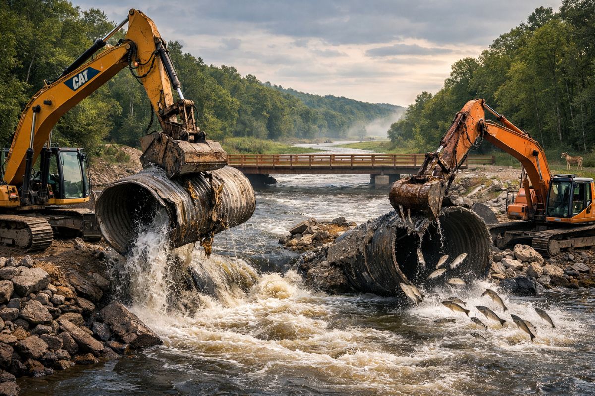
In the Roanoke River, NOAA and The Nature Conservancy Are Removing Undersized Culverts and Barriers That Trap Fish and Water in Floodplains. The Plan Uses US$ 3.2 Million to Install Bridges, Reopen More Than Eight Kilometers of Streams, and 458 Acres of Floodplain Forest, Improving Water and Reducing Prolonged Flooding.
The Roanoke River is at the center of a restoration operation that combines excavators, simple engineering, and applied science to solve an invisible yet devastating problem: undersized road culverts and old stormwater drains that interrupt the natural connection between the main channel, tributaries, and the floodplains where migratory fish need to circulate to complete their life cycle.
By replacing pipes with bridges and removing small blockages scattered throughout the basin, the project restores the Roanoke River‘s ability to rise and fall with flooding, drain the floodplain in a timely manner, maintain oxygen levels in the water, and prevent schools of fish from getting trapped in stagnant pools, while also reducing prolonged flooding that affects landowners and rural communities in North Carolina.
A Giant River, Partly Preserved but Full of Hidden “Locks”

The Roanoke River is described as one of the largest and wildest rivers on the East Coast of the United States. It stretches more than 640 kilometers, starting from the Blue Ridge Mountains and flowing to the Albemarle Sound, forming a broad river system with numerous branches, streams, and floodplain areas that naturally expand when water levels rise.
-
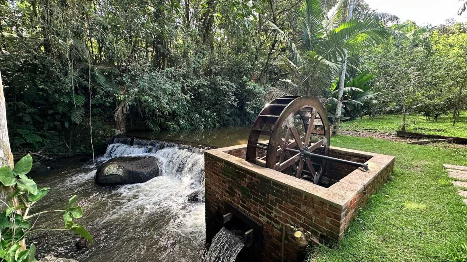
While restoring a historic mansion from 1910, a brick structure with an old turbine that generated energy from the Rio do Testo emerged, along with a hidden door and a rare floor concealed under layers of wax.
-
Italian researchers have detected what appears to be a second Sphinx buried under the sands of Egypt, and satellite scans reveal a gigantic underground megastructure hidden beneath the Giza Plateau for over 3,000 years.

-
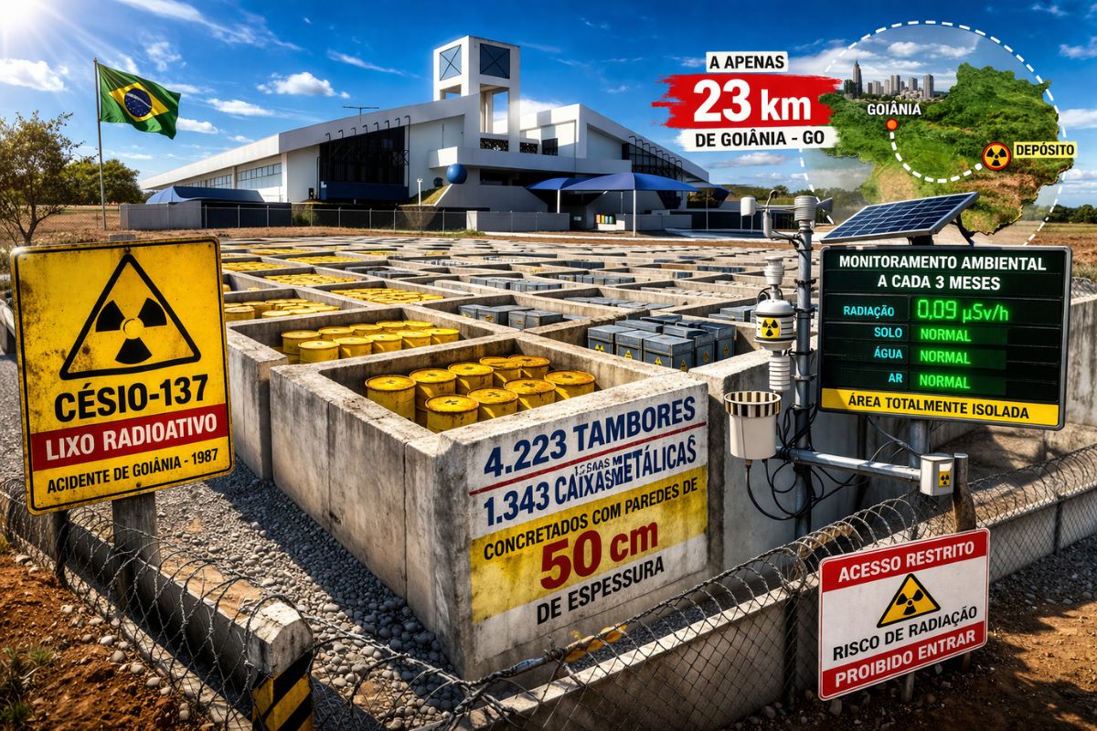
There are 4,223 drums and 1,343 metal boxes concreted with 50-centimeter walls that store the radioactive waste from Cesium-137 in the worst radiological accident in Brazil, just 23 kilometers from Goiânia, with environmental monitoring every three months.
-
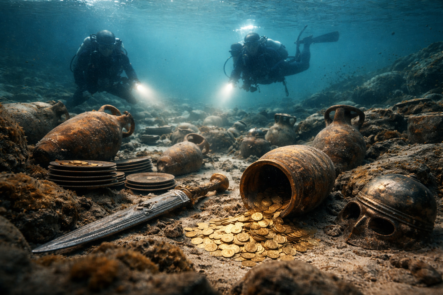
Giant Roman treasure found at the bottom of Lake Neuchâtel in Switzerland reveals an advanced trade system, circulation of goods, and armed escort in the Roman Empire about two thousand years ago.

Although much of the river is preserved, the surrounding landscape has, over the decades, been filled with small but crucial structures: road crossings with old storm drains, culverts with inadequate diameter, and sections with earthen levees. These “locks” disrupt the floodplain, alter the timing of water retention in the floodplain, and break the connectivity that sustains the system’s function.
In the lower Roanoke River, this connectivity is especially valuable because it contains extensive floodplain forests and a floodplain that can reach eight kilometers in width, with nursery habitats that support rare species and one of the only naturally reproducing striped bass populations in the South.
The Real Problem Is Not Just the Fish; It’s Stagnant, Low-Oxygen Water

What makes these culverts so dangerous is not just the physical blockage. The risk comes from the flood dynamics. The Roanoke River has high flows, and when it floods, the water spreads across the adjacent floodplain, rising several meters, creating a network of connected environments that should drain back as the river recedes.
When undersized culverts and debris-blocked structures impede drainage, the water gets trapped. And trapped water becomes another chemical and biological world. Oxygen dissolves less, drops rapidly, and migratory fish that enter the floodplain to spawn or feed end up stranded in stagnant pools.
The logic behind the mortality is straightforward: fish stay alive if the water rises and falls with the river. They die when the water gets trapped for too long in the landscape, with low oxygen, degraded water quality, and no connection back to the main channel.
Why the Roanoke River Is a Critical Corridor for Migratory Fish

The Roanoke River provides essential habitat for the spawning of migratory fish. Among the species that depend on the system are striped bass, blueback herring, hickory shad, American eel, and Atlantic sturgeon, which is described as endangered.
These fish need to access both the main channel and tributaries and floodplain areas. Some species use the floodplain in the spring when water levels rise.
An example cited is the blueback herring, which lays eggs among the horizontal roots of cypress trees, meaning that without connection to floodplain areas with this type of vegetation, the reproductive cycle suffers a direct blow.
When a barrier prevents the fish from reaching the spawning area, the impact is obvious. But when the barrier traps the fish within the floodplain and prevents return as the water recedes, the effect can be even worse because it combines isolation with low oxygen.
The US$ 3.2 Million Project and What Will Be Done in Practice
With US$ 3.2 million in funding from NOAA’s Habitat Conservation Office, The Nature Conservancy is removing barriers along the lower course of the Roanoke River in North Carolina.
The operation has a practical and measurable goal, with deliverables that can be seen on the map and on the ground.
The plan includes replacing six undersized culverts with bridges and removing two additional barriers. The direct result of this reconnection is reopening over eight kilometers of streams and restoring the connectivity of 458 acres of floodplain forest.
This means that water will once again circulate between the main channel and the floodplain, and fish will be able to move freely between the floodplain and the main river. Besides the ecological effect, the project also has human targets: improve water quality and reduce prolonged flooding affecting landowners.
A Larger Effort Since 2019 and the Domino Effect with Landowners
The current action is part of a broader effort to reconnect floodplains and help declining fish populations recover throughout the Roanoke River watershed.
Since 2019, NOAA has been supporting field assessments, outreach to landowners, and barrier removal projects led by The Nature Conservancy.
An important detail is that previous work has had a multiplier effect: landowners have started seeking help on their own properties, expanding the program’s reach beyond what would be possible with just public areas.
The TNC’s water resources director in North Carolina, Julie DeMeester, stated that NOAA’s support has allowed restoration efforts to expand to levels that can make a real difference for important aquatic species.
The expectation, by the end of the collective work, is to unblock more than 110 kilometers of streams and thousands of acres of floodplain forest.
Large-Scale Protection: 95,000 Acres Preserved in the Lower Roanoke River
The ecological value of the lower Roanoke River is not just theoretical. By recognizing the importance of floodplain forests, floodplains, and nursery habitats, state and federal partners, along with The Nature Conservancy, have already protected more than 95,000 acres of land along the lower river.
This level of land protection helps explain why it makes sense to invest in reconnection. It is futile to preserve large blocks if small internal barriers cut off the flow of water and wildlife.
It’s like having a preserved forest but with invisible fences preventing animals from reaching where they need to go.
The Size of the Problem in the Basin: About 1,400 Possible Barriers
Even with targeted restoration projects, the scope of the basin shows why mortality still occurs. It is estimated that there are about 1,400 possible road barriers throughout the Roanoke River watershed.
This means thousands of points where water can get trapped and where fish may be stranded during floods. Therefore, identifying priority sites is critical.
Research has helped determine which areas would benefit most from barrier removal, concentrating resources where the ecological gain is greatest.
Flow Adjustment at Dams: An Important Step, But Insufficient Alone
For decades, The Nature Conservancy has worked with the U.S. Army Corps of Engineers and Dominion Energy to adjust water release patterns at the three dams on the upper Roanoke River, seeking to create a more natural flow in the main channel.
This effort improves river dynamics but does not address the problem of local barriers scattered in streams and road crossings.
Even with a more natural flow in the channel, floods continue to encounter “walls” within the floodplain, where culverts and old levees block drainage.
The practical conclusion is that restoring the river requires two simultaneous fronts: a more natural flow regime in the main channel and physical connectivity in the floodplain and tributaries.
The Field Test: Big Swash versus Company Swamp After the 2025 Flood
One of the strongest pieces of evidence comes from a direct comparison made after a major flood in the spring of 2025.
Researchers compared a restored area, Big Swash, with an area that still had undersized culverts, Company Swamp.
In Company Swamp, 46 hickory shad deaths were recorded in a 150-meter stretch upstream of the storm drain. In Big Swash, where culverts were replaced by bridges, only one hickory shad was found dead in the same distance.
The difference was not just in the count of dead fish. The oxygen levels at the restored site were six times higher than at the site with the storm drain.
The bridges allowed the floodplain to drain and prevented fish from becoming trapped, demonstrating how a seemingly simple intervention can change the fate of an entire ecosystem during a flood.
What Changes When a Culvert Becomes a Bridge: Drainage, Oxygen, and Free Pathway
Replacing a culvert with a bridge simultaneously changes three things in the Roanoke River: water flow, drainage time, and biological connectivity.
The bridge allows water to circulate and recede at the right pace, preventing the floodplain from becoming a low-oxygen trap.
With faster drainage and open connections, stagnant water decreases, quality improves, and fish are no longer trapped.
And when fish are not trapped, they can use the floodplain as they should, entering to spawn, exiting when the water recedes, and continuing their migratory cycle.
Monitoring with Environmental DNA and the Rapid Response of Fish
To monitor the effects of the work, scientists in partnership with TNC use environmental DNA (eDNA) and other tools to track how fish utilize streams before and after restoration.
Initial monitoring already shows that blueback herring and other species gain access to miles of new habitats as soon as storm drains are replaced. Previously, targeted species could not access the habitat. After restoration, they gain miles of tributaries and hundreds of acres of floodplain forest.
This type of rapid response is crucial because it confirms, without relying solely on visual observation, that the restored connectivity is being utilized by fish almost immediately.
Benefits for People: Shorter Floods and Better Water
The restoration of the Roanoke River is also a matter of safety and well-being. Restored floodplains drain more quickly.
When water spreads and recedes naturally, the severity of flooding affecting landowners decreases, reducing the time that land remains saturated and limiting the impact of prolonged floods.
These improvements increase water quality and support traditional regional activities like hunting, fishing, and birdwatching. It’s a chain of benefits: oxygen-rich water supports more aquatic life, more aquatic life supports fishing and recreation, and a functioning floodplain reduces flood damage.
Why Small Projects Together Make a Huge Change
The removal of an isolated barrier may seem like a small thing. But in the Roanoke River, the gain is cumulative. Each bridge installed and each culvert removed is one less point where water and fish can get trapped.
When several points are fixed, the system starts to breathe again like an organism.
The floodplain begins to fulfill its natural function, fish regain migratory routes and spawning areas, water maintains oxygen, and communities suffer less from prolonged flooding.
In the end, the intervention is not “just construction.” It’s returning to the Roanoke River its connected river logic, with floods that come and go, with floodplains that function as nurseries and with an ecosystem that sustains both endangered species and the people who live around it.
If you lived near the Roanoke River, would you prefer to see these bridges replacing culverts even if it affected roads and access, or do you think the social cost always outweighs the environmental gain?


-

-

3 pessoas reagiram a isso.