 Portuguese
  English
  Spanish


Largest Highway in São Paulo Surpasses 654 Km and Exceeds Distances Between European Countries! The Raposo Tavares Connects More Than 30 Cities and Is Vital for the Economy of São Paulo. With Duplicated Sections and Constant Improvements, It Stands Out Among the Best Roads in Brazil. Discover Everything About This Important Transportation Route!
The largest highway in the state of São Paulo is the Raposo Tavares Highway (SP-270), with an impressive length of 654 km.
This route is equivalent to a distance greater than that between Paris and Geneva, illustrating the grandeur of the highway.
The highway plays a crucial role in São Paulo’s infrastructure, linking the capital to various cities in the interior and serving a strategic function in the region’s economy.
-
China is building a city in Brazil: a complex with an investment of R$ 5.5 billion comes to light, but allegations involving workers draw attention.

-
While Argentina buys old war equipment, Brazil is keeping an eye open and joins the select group of nations with advanced military technology by investing $5.2 billion, producing 36 Gripen fighters in the country, and reducing operational costs.

-
Brazil on alert? Why invading Brazil is a NIGHTMARE for the USA: 8.5 million km², 213 million inhabitants, Amazon covering 60% of the territory, trillion-dollar war, and resistance that even 13,000 aircraft could not control.

-
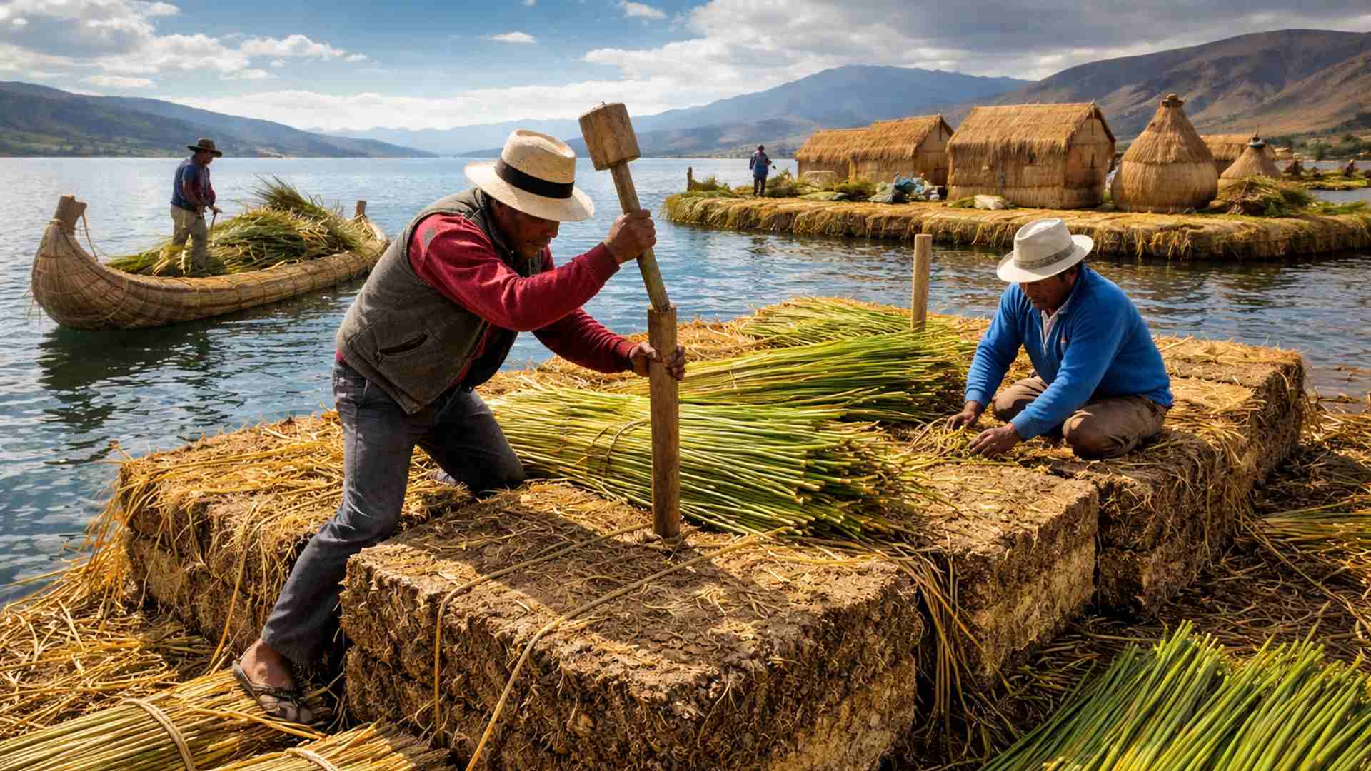
How to build a floating island from scratch with reeds, giant blocks, and stakes in the lake in a process that needs to be repeated almost every day.

Origin and History of the Highway
The Raposo Tavares originated from ancient routes used since pre-colonial times. Part of its path dates back to the Peabiru Path, a trail used by indigenous peoples.
During the 16th and 17th centuries, the route was consolidated by the bandeirantes, later known as the Troops Route and, in the early 20th century, called the São Paulo-Paraná Road.
In 1954, the highway was named Raposo Tavares, honoring Antônio Raposo Tavares, a Portuguese bandeirante who traveled the old route in explorations of Brazilian territory.
Characteristics and Trajectory
The highway starts in the Butantã neighborhood, in the west zone of São Paulo, and extends to the border with Mato Grosso do Sul, in the municipality of Presidente Epitácio.
Along its route, it passes through approximately 30 municipalities, including Osasco, Carapicuíba, Cotia, and Presidente Venceslau.
The highway infrastructure includes sections with single and double lanes. In the first 30 km, the route has three lanes of traffic in each direction.
From Cotia, the highway has marginal roads that facilitate access to neighborhoods and local roads.
In the segment between Sorocaba and Itapetininga, the entire road is duplicated, and some cities have access ramps for better traffic distribution.
Currently, duplication works are underway in the sections between Vargem Grande Paulista and São Roque, as well as between Mairinque and Sorocaba.
Recent improvements include the completion of the Brigadeiro Tobias bypass (km 90 to 87, completed in 2022) and the finalization of the section in the Genebra neighborhood (km 87 to 84.5, in November 2023).
Administration and Concession
Since 2008, part of the highway has been administered by private concessionaires, while another segment remains under the responsibility of the Department of Highways (DER).
The division of management occurs as follows:
- DER: km 10 to 34, km 168 to 381, and km 652 to 654.
- ViaOeste: km 34 to 115.
- SPVias: km 115 to 168.
- CART (Concessionária Auto Raposo Tavares): km 381 to 652.
Throughout the route, there are various toll booths, located in cities like São Roque, Alumínio, Araçoiaba da Serra, Palmital, Assis, and Presidente Bernardes.
The highway also has a User Service (SAU) and bases of the Highway Police, ensuring greater safety for drivers.
Economic Importance
The Raposo Tavares Is One of the Main Logistics Corridors in the State of São Paulo.
Its length and connection with other relevant highways make it essential for the transportation of goods and the flow of agro-industrial production.
Sectors such as agribusiness, industry, and commerce directly benefit from the highway, which shortens distances and enables the rapid movement of goods and people.
Additionally, cities along the highway experience economic development due to the constant flow of vehicles and the establishment of logistics companies.
Curiosities About the Raposo Tavares
The highway is also known by some drivers as the “Highway of Love”, due to the presence of various motels along its route.
Another curious fact is that its length is equivalent to the size of the polar cap of Pluto, making its dimension even more impressive when compared to unusual references.
In 2024, the highway was voted the best in Brazil, according to a survey by the National Transport Confederation (CNT), standing out for its high standards of maintenance and infrastructure.
The Raposo Tavares Highway plays a crucial role in mobility and the economy of São Paulo.
Its historical past, combined with continuous improvements and its logistical relevance, ensures its position as one of the most important roads in Brazil.
Whether for travel, transportation of goods, or regional development, the highway continues to connect the interior of São Paulo to the rest of the country, reinforcing its importance in the national infrastructure.


Viagem várias vezes nessa rodovia , realmente é muito boa e muito bem conservada até Presidente Epitacio ! Parabéns aos administradores !
Sempre pensei que a Castelo Branco fosse a melhor. a estrada de Sorocaba a Itapetininga era conhecida como ramal da fome.
Faltou falar sobre uma das mais importantes cidades da rodovia: Presidente Prudente.