 Portuguese
  English
  Spanish
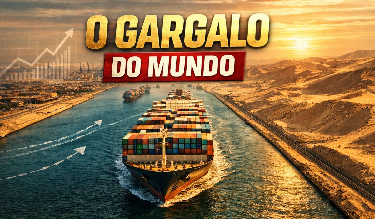
The Canal Shortens Routes Between Europe and Asia by Linking the Mediterranean and Red Sea and Concentrates a Relevant Share of Maritime Trade.
The opening in the 19th century and recent expansions explain its capacity, while blockages expose chain effects on energy, freight, and deadlines.
The Suez Canal in Egypt links the Mediterranean Sea to the Red Sea and is described by international organizations and industry analyses as one of the central passages of maritime trade.
With approximately 193 km in length, the route reduces distances between Europe and Asia by avoiding navigation around southern Africa, which decreases travel time and logistics costs across different types of operations, according to historical and technical descriptions of the waterway itself.
-
These living root bridges and ladders are over 700 years old and help indigenous people survive in one of the rainiest regions in the world.

-
From sertanejo star to international investor: Ana Castela invests millions in a mansion in the USA, creates a themed accommodation in Orlando, and shows that the “boiadeira” also wants to grow away from the stage.

-
The 10 most stunning motorhomes in the world: a $3 million trailer with a rooftop nightclub and garage for a Ferrari, “palaces on wheels” with Italian marble, private cinema, and five-star hotel luxury for billionaires.

-
Trump wanted to spend $400 million on the White House, but the courts prohibited the million-dollar construction.


In frequently cited estimates in reports and analyses on maritime transport, the canal accounts for nearly 12% of global trade in goods and approximately 30% of the world’s container volume transported by ships, although participation fluctuates depending on the year, demand, and type of cargo.
Why The Opening of 1869 Changed Navigation
The inauguration of the Suez Canal on November 17, 1869, changed maritime logistics by opening a direct link between two seas in a region that previously relied on overland crossings and longer routes through the South Atlantic and the Indian Ocean.
The project is associated with French diplomat Ferdinand de Lesseps and was executed with Egyptian participation, in a process that involved technical and operational decisions throughout the construction.

In the adopted design, the canal was conceived as a sea-level passage, without locks.
The option was based on the fact that the average levels of the Mediterranean and the Red Sea are close enough to allow this type of engineering, as recorded in encyclopedic and historical descriptions of the work.
Nonetheless, the traffic scale recorded at the start does not compare to the volume observed today.
Historical surveys indicate that in the first full year of operation in 1870, 486 crossings were recorded, a level well below the flow that the canal would absorb in the 20th century and, especially, in the 21st century.
Engineering Challenges in the Desert and the Mud of Lake Manzala
The excavation crossed desert areas and flood-prone zones, requiring specific solutions to maintain the stability of the banks and the continuity of work.
In the Lake Manzala region, for example, reports on the project highlight that the muddy and unstable soil complicated the opening and support of the route, necessitating the use of compaction and containment techniques.
As the work progressed, mechanization gained ground to accommodate the volume of material to be removed and the demands of the schedule.
Historical records from the period mention the use of dredging equipment and the evolution of available tools, in a context of changes in hiring methods and labor use.
In addition to the terrain, the supporting infrastructure represented another sensitive point.
Ensuring drinking water and supplies for large contingents of workers in arid stretches was a logistical challenge that influenced the pace of the construction site and the organization of excavation fronts, according to historical narratives about the construction.
The way the canal operated over decades also reflected the physical limitations of the route.
The original route functioned, in many stretches, as a single track, with crossing points and wider areas for maneuvers, which conditioned daily capacity and waiting times, according to historical descriptions of the system.
Expansion of 2014–2015 and the “New Suez Canal”
With the pressure for efficiency, larger ships, and time-sensitive costs, Egypt accelerated expansion projects to increase navigation predictability.
The most well-known intervention was associated with the so-called “New Suez Canal,” launched in the context of a program started in 2014 and completed in 2015, when a new parallel section was opened along part of the route.
Diplomatic sources and international reports describe the initiative as a set of works totaling about 72 km of interventions.

This package includes references to 35 km of a new excavated canal and other sections of widening and deepening aimed at reducing operational bottlenecks in specific areas.
The strategy, according to project descriptions, was to tackle the points where navigation was slower and subject to queues, creating segments where ships can advance in opposite directions without solely depending on passing areas.
In practice, the goal was to reduce waiting times and increase logistical predictability, a factor considered relevant by shipowners and global supply chains that work with tighter delivery windows.
In institutional materials, the Suez Canal Authority states that the modernization sought to reduce the transit time of the convoy heading south, referencing a reduction from 18 hours to 11 hours, in addition to decreasing waiting time in certain stretches.
Regarding the cost, international sources describe the expansion package as a project in the range of US$ 8 billion, with variations depending on the methodology used for accounting interventions, financing, and phases of the program.
Blockage of the Ever Given and Effects on Freight and Energy
Interruptions in the Suez Canal often have immediate repercussions because a significant portion of cargo transport passes through a narrow corridor.
In March 2021, the grounding of the container ship Ever Given blocked the route and formed a queue of vessels, impacting delivery deadlines and rerouting.
Estimates cited by international outlets, based on calculations attributed to Lloyd’s List, indicated that the shutdown blocked nearly US$ 9.6 billion per day in maritime traffic.
The value, however, varies depending on the calculation method and does not automatically equate to final losses, as the impact depends on insurance, cargo rerouting, and the ability to recover routes after clearance.
The episode also demonstrated how delays can spread throughout the logistics chain.
According to industry analysts, changes in the flow of oil and derivatives tend to pressure deadlines and delivery costs; likewise, containers with industrial and electronic components can affect production lines that operate with reduced stocks.
When some vessels opt to go around Africa to avoid congestion, the increase in travel time usually raises fuel consumption, influences freight, and alters the availability of ships on other routes, according to recurring analyses in the maritime transport market.


-

-

-

4 pessoas reagiram a isso.