 Portuguese
  English
  Spanish
A Cold Front Advances Through Brazil Causing Significant Atmospheric Instability, Combining a Trough and Cold Air Influx Favoring Heavy Clouds. The System Puts 11 States Under Orange Alert from Inmet, Increases Risk of Storms, Triggers Heavy Rain, and May Generate Waves of Up to Three Meters on the Coast.
The Arrival of a Cold Front This Tuesday (10) Significantly Alters Weather Conditions in Various Regions of Brazil, Creating a Scenario of Instability That Combines Cold, Heavy Rain, and Maritime Agitation on the Southeast Coast.
The System Works Together with an Atmospheric Trough and the Influx of Cold Air, Factors That Favor the Formation of Heavy Clouds and Increase the Risk of Storms. The Result Is a Complex Meteorological Scenario That Puts Several States on Alert for Heavy Rain and Severe Conditions.
Cold Front Triggers Combination of Cold, Heavy Rain, and Unstable Atmosphere
The Passage of the Cold Front Creates a Favorable Environment for Storm Formation in Different Areas of the Country. The Meeting Between Air Masses with Distinct Characteristics Causes Instability, Favoring the Development of Large Clouds Capable of Generating Heavy Rain.
-
Something is happening around the Earth: Inside the huge explosion of fireballs in 2026

-
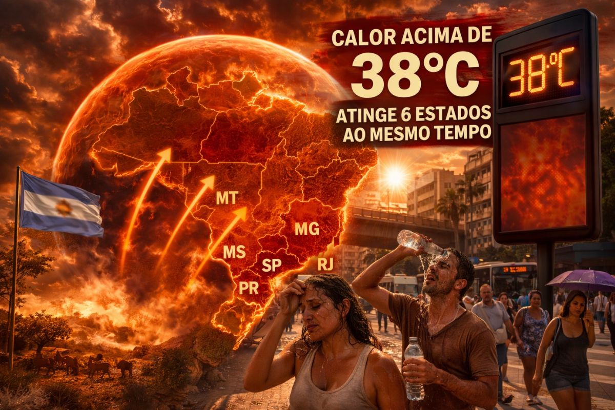
A hot air bubble coming from Argentina expands over Brazil, causing thermometers to exceed 38 degrees with a thermal sensation of 40 degrees in late March, affecting 6 states at once.
-
The radish leaf that almost everyone throws away has more polyphenols, flavonoids, and fiber than the consumed root, and a 2025 study showed that the leaf contains compounds that protect the intestine, combat inflammation, and may inhibit the growth of cancer cells.

-
A planet that seemed to defy the laws of physics has intrigued scientists for decades, until the James Webb revealed what is really affecting Saturn’s rotation.


This Scenario Is Intensified by the Presence of an Atmospheric Trough. The Trough Acts as an Extension of Low Pressure in the Atmosphere, Which Facilitates the Uplift of Warm, Moist Air, Increasing the Formation of Heavy Clouds.
When This System Acts Together with the Circulation of Cold Air, the Atmosphere Tends to Become Even More Unstable. The Result May Be a Series of Episodes of Heavy Rain, Thunderstorms, and Wind Gusts in Various Regions.
Inmet Puts 11 States Under Orange Alert for Storms
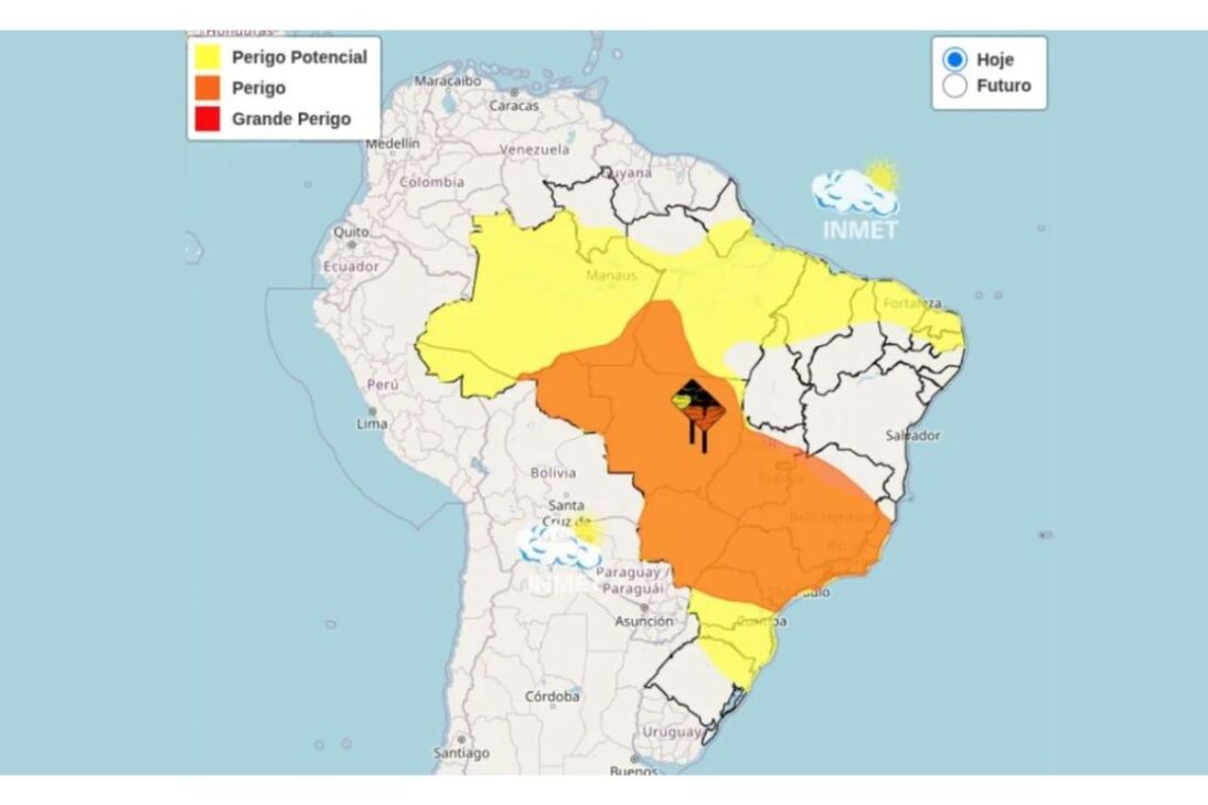
Given the Intensity of the System, the National Institute of Meteorology Issued an Orange Alert for 11 Brazilian States. This Level of Warning Indicates a Dangerous Situation, with the Possibility of Significant Rainfall in a Short Period.
Among the States Under Alert Are Paraná, São Paulo, Minas Gerais, Rio de Janeiro, Espírito Santo, Goiás, Mato Grosso do Sul, Mato Grosso, Rondônia, Amazonas, and Pará. The Cold Front May Cause Rain Accumulations of Up to About 200 Millimeters in Some Areas, Increasing the Risk of Damage.
Other Regions of the Country Remain Under Yellow Alert, Which Represents Potential Danger for Heavy Rain. Even with a Lower Level of Severity, the Conditions Still Require Attention from the Population and Local Authorities.
Southeast Coast Faces Heavy Swell and Waves Up to Three Meters
In Addition to the Rain, the Cold Front Also Causes Significant Effects on the Southeast Coast. The Change in Wind Circulation Generates Maritime Agitation and Increases Wave Height, Especially on the Coast of Rio de Janeiro.
The Forecast Indicates Waves Between 2.5 and 3 Meters, a Typical Scenario of Maritime Swell. This Type of Condition Requires Caution from Fishermen, Navigators, and Beachgoers, as Strong Currents and Rough Seas Can Represent Risk.
The Recommendation Is to Avoid Activities at Sea During the Period of Greater Agitation and to Increase Attention in Coastal Areas. In Emergency Maritime Situations, Contact with the Fire Department Can Be Made via Phone 193.
South, Southeast, and Center-West Regions Concentrate Highest Risk of Rain
The Effects of the Cold Front Tend to Be More Intense in the South, Southeast, and Center-West Regions. In These Areas, the Combination of High Humidity, Terrain, and Atmospheric Circulation Increases the Likelihood of Storms.
In the South, Paraná Appears as One of the Most Susceptible Areas to Large Volumes of Rain, Especially in Cities Near the Border with São Paulo. The Presence of Abundant Humidity Favors the Formation of Persistent Rain Cells.
In São Paulo, Nearly the Entire State Remains on Alert. The Highest Risk Is Concentrated in the West and Northwest of São Paulo, Where Storms May Be Accompanied by Thunderstorms and Significant Accumulations of Precipitation.
Minas Gerais Also Comes Under Meteorological Radar, Particularly in the Triângulo Mineiro, in the South of the State and in the Zona da Mata. These Areas Have Recently Recorded High Rainfall Volumes, Increasing Concern About New Episodes of Intense Precipitation.
Humidity, Terrain, and Wind Circulation Intensify Storms
Another Factor That Strengthens the Instability Scenario Triggered by the Cold Front Is the Transport of Humidity by Winds Coming from the Ocean. This Flow Continuously Feeds the Thunderstorm Clouds Forming Over the Continent.
In the Coastal Areas of the Southeast and the South, the Terrain Also Plays a Significant Role. Regions with Mountain Ranges Close to the Sea Favor the Blocking of Clouds and Increase the Time of Rainfall Areas, Elevating Accumulations.
In the Center-West, the Effects Can Also Be Significant. Mato Grosso do Sul and Mato Grosso Present Higher Possibility of Intense Rain, a Situation That May Interfere with Agricultural Activities, Especially During Harvest Periods.
In Goiás, Precipitation Tends to Occur with Greater Intensity in the Southern Portion of the State, While Other Areas May Record More Isolated Episodes of Rain.
Atmospheric Instability Requires Attention in Several Regions
The Action of This Cold Front Demonstrates How Different Meteorological Systems Can Combine and Cause Rapid Weather Changes Across Much of the Country.
The Simultaneous Presence of Cold Air, Atmospheric Trough, Humidity Transport, and Wind Circulation Creates a Highly Unstable Environment. This Type of Configuration Increases the Possibility of Storms, Heavy Rain, and Impacts on Urban and Rural Activities.
The Recommendation Is to Monitor Weather Alerts and Stay Attentive to Updates on Weather Conditions, Especially in Regions That Are Already Facing High Rainfall Volumes.
The Cold Front Has Already Started to Cause Changes in Several Regions of Brazil, with Temperature Drops, Increased Cloudiness, and Occurrence of Heavy Rain in Some Areas.
Now We Want to Know: Has the Weather Changed in Your City with Rain, Wind, or Temperature Drop? Let Us Know in the Comments How the Weather Is Where You Live and If the Effects of This Cold Front Are Already Being Felt.


Seja o primeiro a reagir!