 Portuguese
  English
  Spanish
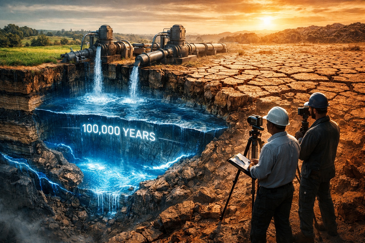


Planet’s Aquifers Enter Silent Collapse: NASA Satellites Detect Accelerated Depletion of Groundwater in Major Reserves Worldwide
Global Groundwater Crisis: NASA Satellites Reveal Emptying of Major Aquifers. The largest aquifers on the planet are entering a silent collapse process. NASA satellites measured the gravitational loss of 21 of the 37 largest groundwater systems in the world, indicating a significant reduction in the volume of water stored beneath the surface. This data was obtained from the GRACE mission (Gravity Recovery and Climate Experiment), which monitors mass variations on the planet associated with the movement of water. Among these groundwater systems, thirteen are being depleted without receiving virtually any significant natural recharge. Hydrologically, this means that the volume extracted annually by pumping dramatically exceeds the amount of water that infiltrates back underground through rainfall or natural recharge processes.
The results are already becoming evident in various critical agricultural regions of the planet. In the United States, India, Pakistan, and parts of Brazil, farmers need to deepen wells every year to reach the groundwater that continues to recede. This phenomenon of continuous decline in groundwater levels is turning ancient aquifers into temporary reservoirs for intensive exploitation. This process occurs because aquifers function as extremely slow geological systems for water storage. Unlike surface reservoirs, which can be quickly replenished by rainfall or rivers, much of the groundwater has accumulated over thousands or even millions of years.
NASA data indicates that several of the largest underground freshwater reservoirs on the planet have already exceeded the limit considered sustainable for extraction.
-
How the terraforming of Mars can transform the planet: artificial aerosols can increase the temperature by up to 35°C in 15 years, creating conditions for liquid water.

-
Scientists drilled nearly 8,000 meters into the ocean floor above the fault that caused the 2011 tsunami in Japan and discovered that a layer of clay 130 million years old was responsible for making the wave much worse than any model had predicted.
-
Thousands of years after causing the largest eruption of the Holocene, one of the world’s largest supervolcanoes is rebuilding itself beneath the sea south of Japan, receiving new magma and alarming scientists with its transformation.
-
China has activated a magnet 700,000 times more powerful than the Earth’s magnetic field that operates for over 200 consecutive hours while consuming little energy, and now the world wants to know what Beijing plans to do with this technology in 2026.


How Aquifers Form and Why Natural Recharge of Groundwater is Extremely Slow
Groundwater does not function like a faucet that can be turned on or off according to human consumption. Aquifers are complex geological systems that form over long periods of time.

The process begins when rainwater infiltrates the soil and slowly passes through layers of permeable sediments and rocks, such as sandstones and limestones. This water travels microscopic pathways between the pores of the rocks until it reaches geological formations capable of storing it in large quantities. These formations function like true underground sponges.
The speed of this process is extremely slow. In many aquifers, water moves only centimeters per year. This means that the water supplying cities and agricultural areas today may have entered the ground thousands or even hundreds of thousands of years ago.
The Guarani Aquifer, one of the largest underground freshwater reservoirs in the world, illustrates this phenomenon well. It supplies more than 90 million people in seven Brazilian states, as well as regions of Paraguay, Argentina, and Uruguay.

Studies conducted by researchers from Unesp indicate that, in some areas of the interior of São Paulo, the water present in the springs has currently taken more than 100,000 years to reach the underground system.
Monitoring conducted in the Brotas region has shown that current rainfall does not replenish the volume of water being extracted by wells and catchment systems.
This means that part of the water used today was accumulated during much older climatic periods in Earth’s history.
Ogallala Aquifer: Reserve Formed Millions of Years Ago Loses Water at an Accelerated Rate
One of the most studied cases of aquifer depletion in the world is the Ogallala Aquifer, also known as the High Plains Aquifer. This massive underground system extends over approximately 450,000 km², crossing eight states in the United States, from South Dakota to Texas.
The Ogallala was formed between 2 and 6 million years ago, when sediments and water from the melting of the Rocky Mountains accumulated in vast sedimentary plains. Today, it supports one of the largest agricultural regions on the planet.

About 27% of all agricultural irrigation in the United States directly depends on this underground reserve, including approximately 20% of the national production of wheat, corn, cotton, and beef.
Since the 1940s, nearly 200,000 wells have been drilled to extract water from the aquifer. The problem is that the natural recharge of the Ogallala is extremely slow. The natural replenishment rate is approximately 2.5 centimeters per year, while in some areas, extraction exceeds 1 meter per year.
This difference creates a dramatic proportion: forty times more water is being withdrawn than is naturally replenished. In 2024, measurements conducted by the Kansas Geological Survey confirmed that parts of western Kansas lost more than 30 centimeters of groundwater level in just one year.
State authorities warned that some agricultural areas may face critical water shortages in the coming decades. If the Ogallala aquifer were completely drained, its natural recovery could take about 6,000 years.
Indo-Gangetic Basin: Aquifer Supporting 1.5 Billion People Under Extreme Pressure
Another extremely pressured underground system is the aquifer of the Indo-Gangetic Basin, which covers large areas of India, Pakistan, and Bangladesh. This region is home to approximately 1.5 billion people and relies heavily on groundwater irrigation to sustain its agricultural production.
During the Green Revolution of the 1960s and 1970s, the Indian state of Punjab became one of the most productive agricultural regions in Asia. The intensive cultivation of rice was expanded thanks to groundwater pumping irrigation.

The problem is that rice requires large volumes of water and is grown in a region where rainfall is insufficient to support this demand. As a result, the water table has been steadily declining. Farmers need to drill deeper wells, which increases production costs and generates growing indebtedness.
The situation has recently worsened with the spread of solar-powered pumps. The cost of electricity for pumping has dropped dramatically, allowing for more frequent irrigation. However, this reduction in cost has also increased the speed of groundwater extraction.
Reports obtained by Reuters in 2025 indicate that groundwater levels in Pakistani Punjab are falling rapidly. The technology that reduced pumping costs has ended up accelerating the depletion of the aquifer.
21 of the 37 Largest Aquifers on the Planet Have Exceeded Sustainable Limits
One of the most comprehensive studies on the global status of groundwater was published in 2024 in the scientific journal Nature. The research analyzed data from 170,000 monitoring wells distributed across 1,693 aquifer systems in over 40 countries.
The results show that approximately 30% of the analyzed aquifers exhibit accelerated declines in water levels, well above what is expected under natural conditions. In aquifers monitored by NASA’s GRACE satellites, 21 of the 37 largest aquifers on the planet have already exceeded the limits considered sustainable for exploitation.
Eight of them were classified as extremely overloaded, with practically nonexistent recharge. Among the most critical is the Arabian Aquifer System, which supplies over 60 million people in the Middle East. The Indus Basin immediately follows on the list.
Another factor identified by researchers is that excessive groundwater pumping also contributes to rising sea levels. When water is extracted from underground, it eventually evaporates, flows into rivers, or is transported to the oceans. In practice, humanity is transferring water that was stored inside the Earth to the seas.
Land Subsidence: When Groundwater Withdrawal Causes Cities to Sink
The depletion of aquifers not only causes supply crises. It also causes profound geological changes. When the water present between the pores of the rocks is removed, the sediments begin to compact permanently. This phenomenon is known as land subsidence.
When it occurs on a large scale, the ground above the aquifer can literally sink. Jakarta, the capital of Indonesia, presents some of the most dramatic cases. Parts of the city have already sunk more than 4 meters, primarily due to intensive groundwater pumping.

Shanghai recorded subsidence of over 2 meters during the 20th century before imposing severe restrictions on pumping. Manila, in the Philippines, exhibits subsidence rates of up to 100 millimeters per year in some neighborhoods.
In California’s Central Valley, subsidence has been so intense that it has damaged irrigation canals and required repairs costing hundreds of millions of dollars. Studies published in the Journal of Geophysical Research: Solid Earth show that this type of geological compaction is practically irreversible.
Even if the aquifer receives water again, the compressed pore space does not expand again.
Brazil Relies More and More on Groundwater
Brazil currently ranks as the ninth largest consumer of groundwater in the world. In many cases, the resource is used without detailed monitoring or integrated management.
In the state of São Paulo, more than 75% of municipalities rely on aquifers for public water supply, and approximately 5.5 million residents of the capital use groundwater daily.
The Bauru-Caiuá Aquifer, which extends over areas of São Paulo, Minas Gerais, Mato Grosso do Sul, Goiás, and Mato Grosso, could lose nearly 28% of its recharged volume by the end of the century, according to projections published in 2024 by the Geosciences Institute of USP and Inpe.
Recent research also shows that intensive pumping can reverse the natural flow between rivers and aquifers. Under natural conditions, aquifers release water to rivers during dry periods. When the underground level drops too much, the process reverses: rivers begin to lose water to the subsoil.
Studies on the São Francisco River indicate a consistent decline in the so-called base flow, which represents the portion of flow maintained by groundwater.
Managed Aquifer Recharge Emerges as a Technical Solution to Water Crisis
One of the most discussed solutions to reduce aquifer depletion is called Managed Aquifer Recharge (MAR). This technique consists of directing rainwater, rivers, or treated sewage to structures designed to increase infiltration into the ground.
Among these structures are infiltration basins, recharge dams, underground trenches, and direct injection wells. Madrid has been using such systems since the 1990s. Israel reuses about 85% of its treated sewage, some of which is designated for aquifer recharge.
In Brazil, the SACRE Project, funded by Fapesp and coordinated by Professor Ricardo Hirata from USP, is studying the application of this technology in the state of São Paulo. Bauru was chosen as a pilot city to test different models of artificial recharge. However, experts say that the main obstacle is not technological.
The central issue is the lack of integrated governance. In many countries, surface and groundwater are managed by different agencies, as if they were independent systems. Meanwhile, pumping continues to increase.
The water that took tens or hundreds of thousands of years to accumulate in the aquifers is being withdrawn in just a few decades.


The planet will not survive overpopulation. Malthus will be proved to have been correct, and Darwin will do the rest.