 Portuguese
  English
  Spanish
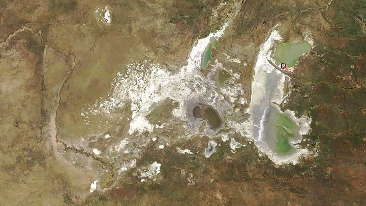
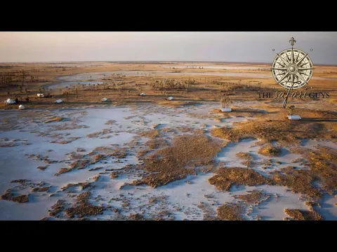
The Makgadikgadi Salt Pans in Botswana alternate between extreme saline desert and seasonal shallow sea, revealing one of the most impressive geological systems in Africa.
In 2024, orbital images released by NASA once again highlighted the extreme scale of the Makgadikgadi Salt Pans in northern Botswana. According to the official record from the MODIS sensor aboard the Terra satellite, the system covers about 30,000 square kilometers and represents the remnant of the ancient Makgadikgadi Lake, an African mega-lake that, according to the agency itself and the NASA Earth Observatory, once occupied a much larger area in the region.
For most of the year, the scene is one of an almost absolute white desert, formed by highly reflective mineral crusts in an area that is normally arid. However, as the rainy season progresses, the landscape undergoes a radical transformation: rainwater moistens the saline crust and creates shallow sheets of water that spread across wide stretches of the plain, completely changing the appearance of the terrain.
This alternation between extreme aridity and seasonal flooding makes the Makgadikgadi Salt Pans one of the most dynamic and visually impactful natural systems in Africa, combining geological scale, hydrological variation, and a landscape that reorganizes according to the rainfall regime.
-
The United Kingdom is transforming toilet paper removed from sewage into an ambitious and surprising project that could forever change the way cities and industries view one of the most unthinkable everyday waste products.

-
The USA launches a colossal ship with over 63,000 tons, 272 meters in length, and capacity for 1,000 beds and 11 operating rooms: a floating hospital for crises in different oceans.

-
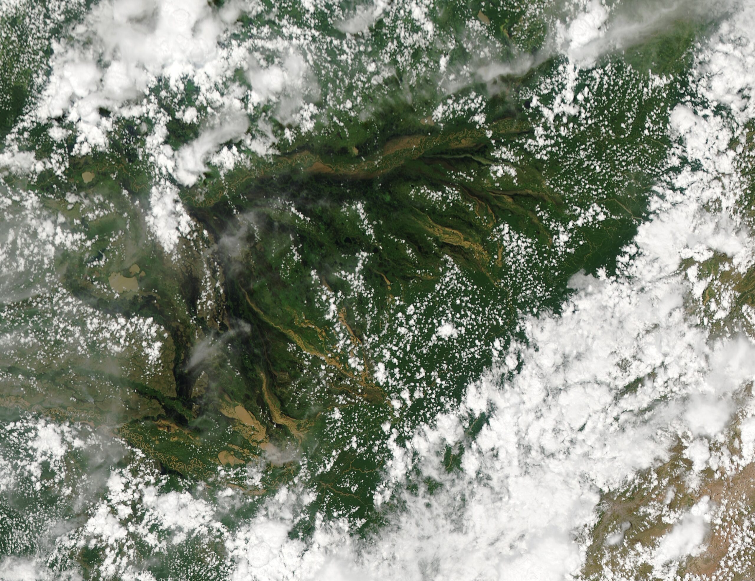
In Bolivia, the Llanos de Moxos form a plain of 6.9 million hectares connected to the Amazon basin that floods every year with hydrological pulses of up to 5 meters, creating a continental labyrinth of rivers, lakes, and seasonal channels visible from space.
-
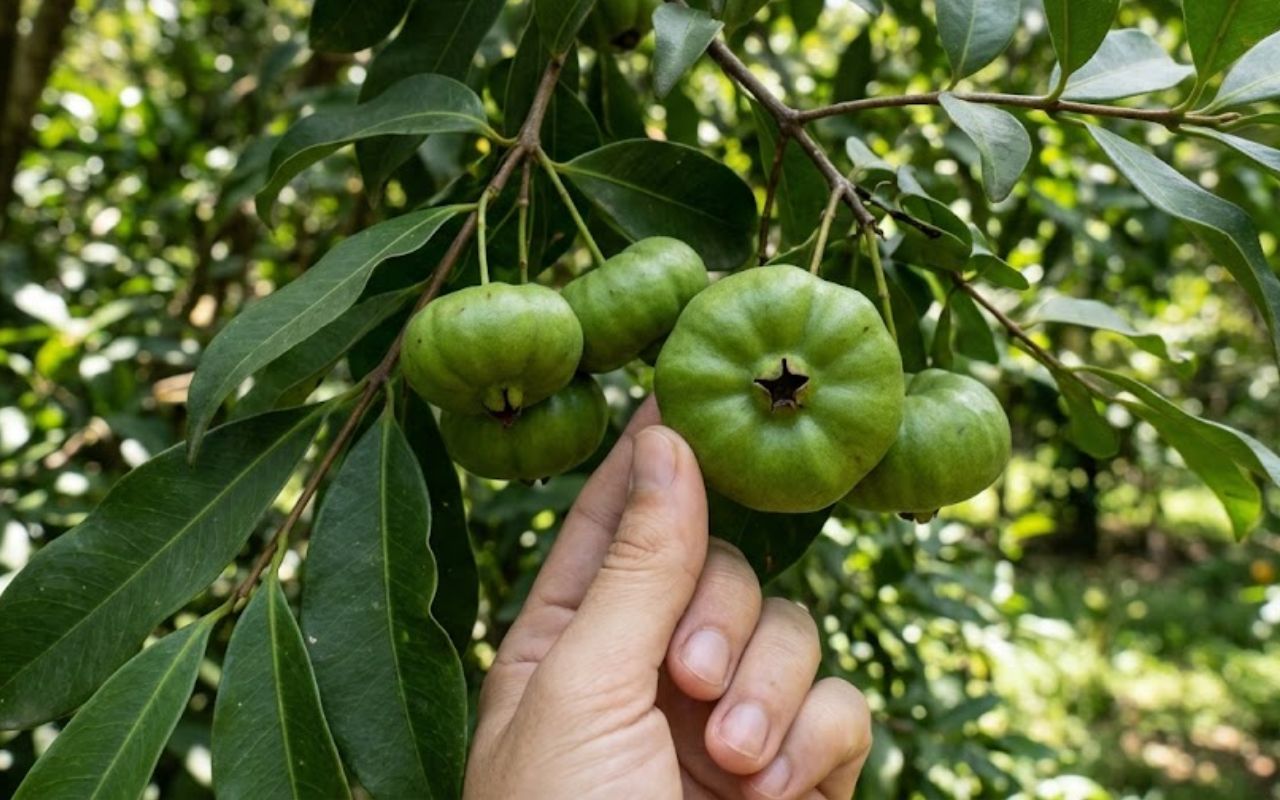
Little-known fruit from the Atlantic Forest draws attention for combining an acidic flavor, high vitamin C content, and antioxidants that help combat free radicals. It can be used in juices, jams, ice creams, liqueurs, sauces, meats, and savory dishes; meet the cambuci (Campomanesia phaea).
Geological formation of the Makgadikgadi reveals an ancient mega-lake that dominated southern Africa
Geological studies indicate that the Makgadikgadi Salt Pans are what remains of a vast lake system known as the Paleolake Makgadikgadi, which existed tens of thousands of years ago and occupied a much larger area than the current one.

This mega-lake was fed by ancient river systems and was once one of the largest bodies of water on the African continent. Over time, climate changes and alterations in the terrain led to the progressive reduction of water volume.
Intense evaporation, combined with the decrease in water inflows, led to the collapse of the lake, leaving behind deposits of salt and sediments that today form the plains.
This process transformed a vast ancient aquatic system into one of the driest and most extreme environments in modern Africa. The marks of this transition can still be observed in the soil composition and the relatively flat topography of the region.
How the rainy season transforms the saline desert into a temporary shallow sea
Despite its arid appearance, the Makgadikgadi Salt Pans still maintain connections with seasonal hydrological systems. During the rainy season, which occurs between November and March, intense rains and the flow of temporary rivers feed the basin.
Rivers like the Boteti play an important role in this process, bringing water to parts of the plain. As water accumulates, a shallow sheet forms that can extend over large areas.
The depth rarely exceeds a few centimeters, but the horizontal extent creates the impression of a shallow sea emerging in the middle of the desert.
This phenomenon is extremely dependent on climatic conditions and can vary significantly from year to year.
In dry years, flooding may be minimal or nonexistent. In years of heavy rains, the transformation is broader and visually striking.
Salt plain that changes shape every year challenges maps and geographical interpretation
Like other endorheic systems, the Makgadikgadi Salt Pans do not have a fixed shape. The extent of flooded areas varies according to rainfall volume, flow directions, and local topography.
This causes the system to exhibit significant changes over time. Areas that remain dry in one year may be completely flooded the next.
Additionally, rapid evaporation causes the formation of geometric patterns in the soil, creating cracked surfaces that change constantly.
This dynamic behavior makes the system difficult to map accurately and requires continuous monitoring by satellites. Seasonal variation also influences sediment distribution and the formation of new salt layers.
Visibility of the Makgadikgadi Salt Pans from space reinforces their continental scale
One of the most impressive features of the Makgadikgadi Salt Pans is their visibility in satellite images. During dry periods, the highly reflective white surface stands out clearly in the context of the African landscape.
During the rainy season, the presence of water creates striking visual contrasts, with dark areas representing flooded surfaces and light regions indicating exposed saline crusts.
This orbital visibility places the system among the most easily identifiable on the planet in geographical terms. Furthermore, satellite observation allows tracking the evolution of flooded areas and better understanding the climatic patterns influencing the system.
Climatic dynamics and extreme evaporation shape the behavior of salt plains
The climate of the region is characterized by high temperatures and low relative humidity for much of the year. These conditions favor high evaporation rates.
When water accumulates on the plains, it begins to evaporate rapidly, leaving behind dissolved salts that crystallize on the surface.
This continuous process is responsible for maintaining the saline crust that defines the landscape of the Makgadikgadi. Intense evaporation is the main factor preventing the formation of a permanent lake, even when there is significant water inflow.
Additionally, the cycle of evaporation and salt deposition directly influences the chemical composition of the soil.
Scientific importance of the Makgadikgadi for global climatic and geological studies
The Makgadikgadi Salt Pans are often used as a reference in studies on climate change, desertification, and the evolution of lake systems.
The sedimentary record present in the region contains valuable information about climatic variations over thousands of years. This data helps scientists reconstruct patterns of rainfall, temperature, and hydrological dynamics of the past.
Furthermore, the system serves as a model for understanding how large bodies of water can disappear over time, leaving lasting geological traces.
This scientific relevance extends beyond the African region, contributing to global studies on extreme environments and environmental changes.
Why this natural system continues to be one of the most extreme on the planet
The Makgadikgadi Salt Pans combine rare factors: origin in a mega-lake, complete transformation of the environment, intense seasonal dynamics, and continental scale.
The alternation between an absolute saline desert and a temporary shallow sea demonstrates how natural systems can operate at opposite extremes within the same annual cycle.
Moreover, the visibility of the phenomenon on an orbital scale reinforces its importance as a global geographical reference.
Few places in the world exhibit such drastic and recurring transformation over a relatively short period.
This type of extreme transformation between desert and lake can occur in other regions of the planet
The case of the Makgadikgadi raises an important question for science: to what extent can similar systems exist in other parts of the world, operating under specific climatic and geological conditions?
Arid regions with endorheic basins have the potential for similar behaviors, but few reach the scale and intensity observed in Botswana.
In light of this, a relevant reflection arises: how many other ancient mega-lakes may have disappeared throughout Earth’s history, leaving only silent traces that still alternate between water and desert today?


Seja o primeiro a reagir!