 Portuguese
  English
  Spanish
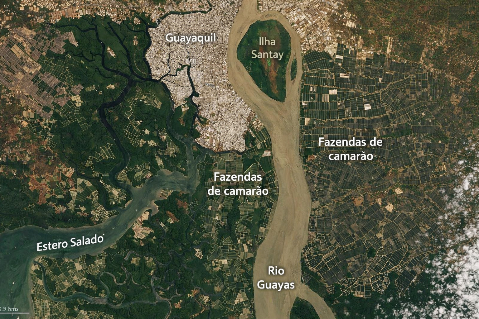
In Ecuador, port city surrounded by aquaculture tanks forms visible patterns of space, revealing a little-known coastal transformation.
In recent analyses released by the NASA Earth Observatory, satellite images of the Guayas River estuary in Ecuador revealed a phenomenon that only becomes fully understandable when viewed from space. South of the city of Guayaquil, the largest and most important port area in the country, thousands of rectangular aquaculture tanks spread across the coastal landscape forming a geometric pattern so striking that it resembles artificial neighborhoods drawn over the water.
These structures, primarily used for shrimp farming, transformed natural mangrove and wetland areas into a productive grid organized in rectangular blocks. What was once a landscape dominated by natural ecosystems now displays a highly visible industrial design in orbital images, revealing the scale of an economic activity that has silently grown over the past decades.
Nasa itself highlights that this transformation is so extensive that it can be easily detected by sensors such as those on Landsat and Sentinel satellites, evidencing how human intervention has completely redrawn the coastal region.
-
How much does an iFood delivery person earn? Here are approximate earnings values per day, week, and month.

-
Millions of people throw away broken hoses without knowing that this durable and flexible material can be transformed into two valuable items for the home at almost no cost.

-
Do dogs “sing” along with music? A study reveals that some pets adjust their howling to the sound of music.

-
Bill Gates revealed that he prefers to hire lazy people for difficult tasks because they always find the easiest way, and this philosophy explains Microsoft’s success to this day.

Expansion of aquaculture created thousands of interconnected rectangular tanks along the estuary
The pattern observed in the Guayas estuary is not random. It follows a specific productive logic of intensive aquaculture, where large areas are divided into shallow tanks for shrimp cultivation.
These tanks are built from dikes and channels that control the inflow and outflow of water, creating ideal environments for the growth of the animals. When replicated on a large scale, these modules form a continuous system that, when viewed from above, takes on a highly geometric appearance.

The result is a mosaic of thousands of rectangles organized side by side, separated by lines that function as water circulation channels and operational infrastructure. In some stretches, this repetition is so intense that the landscape completely loses its natural appearance and begins to resemble a planned structure on an urban scale.
This pattern not only draws visual attention but also indicates the level of industrialization of the activity, which has shifted from artisanal to large-scale operations.
Guayaquil region concentrates one of the largest shrimp productions in the world
Ecuador is currently one of the largest shrimp exporters on the planet, and a large part of this production is concentrated precisely in the Guayas estuary region. The proximity to the ocean, the presence of naturally flooded areas, and favorable climatic conditions created an ideal environment for the development of aquaculture.
The city of Guayaquil serves as the main logistical hub of this production chain, connecting cultivation areas to international markets through its port. This integration between production and export was one of the factors that drove the accelerated expansion of nurseries along the coast.
With the increase in global demand for shrimp, especially in recent decades, the region has undergone a continuous process of converting natural areas into productive structures, further expanding the presence of these rectangular tanks.
Satellite images show substitution of mangroves by productive areas
One of the most relevant points identified in studies and orbital images is the replacement of natural ecosystems by aquaculture structures. Mangroves, which once dominated much of the region, have gradually been converted into shrimp farms.
This transformation profoundly altered the environmental dynamics of the estuary, modifying vegetation, water circulation, and local biodiversity. The conversion of these areas did not occur sporadically but rather over decades, creating a cumulative process that is now clearly visible from space.

The images analyzed by NASA show the evolution of this occupation, evidencing how previously continuous areas of vegetation have been fragmented and replaced by artificial geometric patterns.
Geometric pattern seen from space transforms landscape into “artificial water neighborhoods”
The most impressive aspect of this phenomenon is how it visually presents itself. When observed in satellite images, the set of tanks creates an effect similar to that of planned neighborhoods, but instead of streets and houses, what is seen are bodies of water bordered by dikes.
Each tank functions as an independent productive unit, but all are connected by a hydraulic network that ensures the operation of the system as a whole. This organization creates a visual repetition that reinforces the sense of artificial structure.
In certain areas, the density of these tanks is so high that the landscape becomes almost completely occupied by rectangular shapes, eliminating any visual reference to the original natural environment.
Earth observation technology allows tracking growth over the years
The use of satellites like Landsat has allowed not only the identification of this pattern but also the tracking of its evolution over time. Comparisons between images from different decades clearly show the progressive expansion of aquaculture areas.
Regions that once appeared as natural areas have become occupied by geometric structures, evidencing the advance of the activity. This type of monitoring is essential to understand the impact of large-scale aquaculture and to document environmental changes.
Moreover, these images help quantify the extent of occupied areas, providing important data for scientific studies and public policies.
Industrial aquaculture redefines the relationship between production and coastal territory
The case of the Guayas estuary exemplifies how modern aquaculture can completely transform land use. Unlike traditional fishing, which depends on natural environments, shrimp farming in nurseries allows for greater control over production conditions.
This results in higher productivity but also requires significant physical infrastructure, which permanently alters the landscape. The construction of dikes, channels, and tanks modifies the relief and hydrodynamics of the region, creating a new type of environment.
This change represents an important transition in the way marine resources are exploited, replacing traditional practices with industrial systems.
Visible transformation from space reveals direct impact of human activity on the coast
The fact that these structures are clearly visible from space reinforces the scale of the impact caused by aquaculture. These are not sporadic changes but a territorial reconfiguration that can be observed at an orbital level.
The landscape of the Guayas estuary has become a clear example of how economic activities can redraw entire regions, creating patterns that did not previously exist. This visibility increases scientific interest and also highlights the need for environmental monitoring.
The ability to observe these transformations in real-time allows for a broader understanding of the consequences of industrial expansion in coastal areas.

The case of Ecuador joins other global examples of artificial landscapes seen from space
Although the Guayas estuary is one of the most striking examples in South America, similar phenomena occur in other parts of the world, such as Southeast Asia and North America. However, the scale and density observed in Ecuador make the case especially relevant.
The repetition of geometric patterns in natural environments is a common characteristic of modern industrial activities, but rarely reaches such an evident level as observed in this region.
This type of landscape has become a new element of the planet, combining economic production with large-scale territorial transformation.
Have you ever imagined that productive structures can transform the landscape to the point of being seen from space?
The case of the Guayas estuary shows how seemingly localized activities can gain global proportions when analyzed from orbital images. What, at ground level, may seem like just a production area, reveals itself as an impressive geometric pattern when viewed from space.
In light of this, an important reflection arises: to what extent can the expansion of activities such as aquaculture continue transforming natural landscapes into artificial structures visible on a planetary scale? Leave your opinion in the comments.


Seja o primeiro a reagir!