 English
  Francês
  Alemão
  Italiano
  Japonês
  Norueguês
  Portuguese
  Spanish
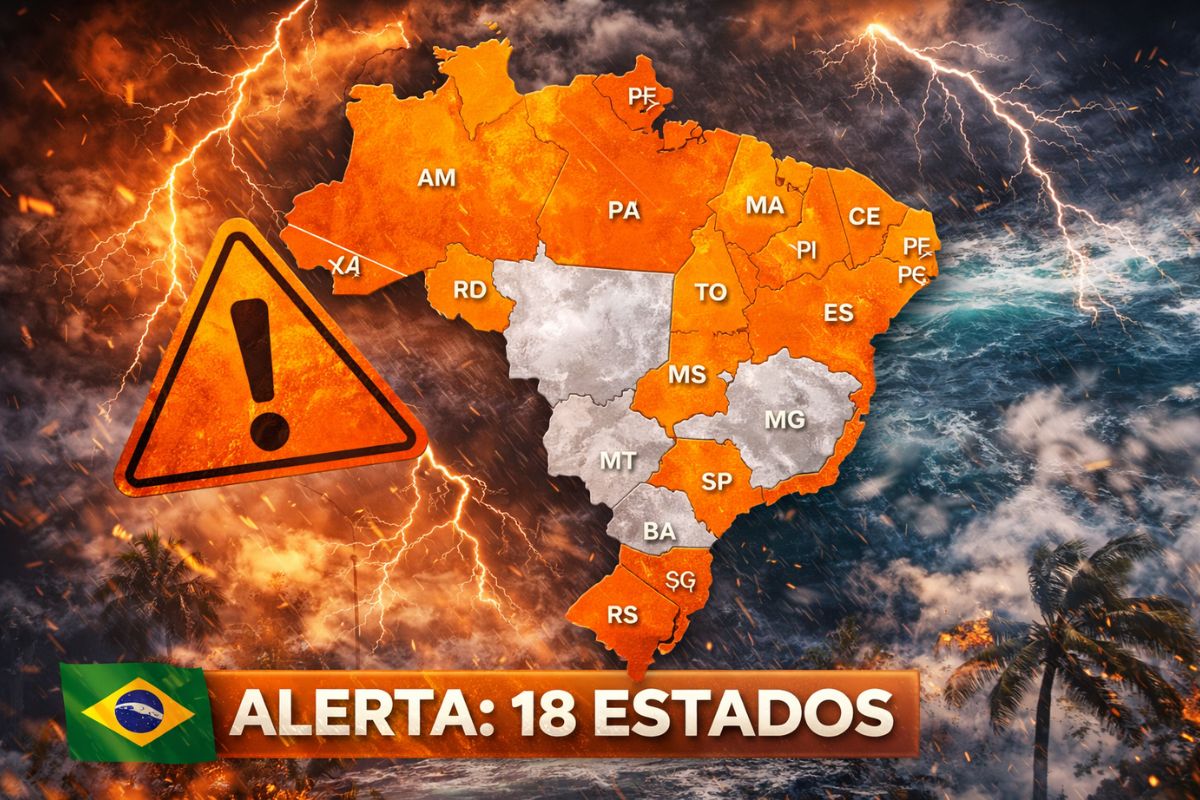
The Inmet forecast indicates an orange alert for storms in 18 Brazilian states this Wednesday (25). The passage of a cold front brings intense rains with lightning, winds of over 60 km/h, and the risk of flooding, falling trees, and power outages in a large part of the country.
The weather forecast for this Wednesday (25) places 18 Brazilian states under an orange alert for the risk of severe storms. According to Inmet (National Institute of Meteorology), the arrival of a cold front in southern Brazil is causing significant changes in the weather across almost the entire national territory. In total, 21 states are under some level of weather warning, with 18 of them concentrating the most severe alert, predicting intense rains, electrical discharges, and wind gusts exceeding 60 km/h.
The forecast indicates that the rains may accumulate up to 100 mm in some regions and may be accompanied by violent winds capable of toppling trees, causing flash floods, and interrupting the supply of electricity. The scenario affects areas from Rio Grande do Sul to northern states such as Acre, Amazonas, and Pará, passing through the Midwest and Southeast, in a stretch of instability that rarely encompasses so many regions at the same time.
What does the Inmet forecast say for the next few hours
Inmet issued a yellow alert for 21 states and, within this group, raised the level to an orange alert in 18 of them, indicating a risk of storms with the potential to cause damage. The forecast indicates that the most severe conditions are expected to occur starting in the afternoon of this Wednesday (25), when the strengthening of atmospheric instabilities tends to intensify the rain showers.
-
The climate in 2026 may surprise with extremes even more intense than in 2025, with heatwaves, out-of-season cold, and irregular rainfall in Brazil.

-
Astronomers identify 45 rocky planets that could harbor life, and one of them is just 4.2 light-years from Earth, making it the closest neighbor with the potential to have liquid water on its surface.

-
Archaeologists discover 43,000 ostraca in Egypt with tax lists, drawings, religious texts, and everyday notes that reveal what life was like in ancient Athribis before Cleopatra.

-
China showcases laser defense systems that target drones flying very low and attempts to address a flaw that has been concerning armies worldwide.


According to Meteored, the cold front continues to advance through Brazilian territory and directly influences the weather from the early hours of the day.
During the early morning, moderate rains have already been recorded in Rio Grande do Sul, Mato Grosso do Sul, Goiás, and Minas Gerais. The forecast is that throughout the day, the intensity will progressively increase, with the possibility of fog in regions with higher humidity and milder temperatures.
Which states are under orange alert according to the forecast
The Inmet forecast places states from all five regions of Brazil under an orange alert. In the South, the highest volumes of rain are expected to concentrate in the north of Rio Grande do Sul, western Santa Catarina, and Paraná, where the storms tend to be more organized and intense.
In the Southeast, rains return after a period of greater stability. Minas Gerais, Rio de Janeiro, Espírito Santo, and the eastern part of São Paulo are again registering the formation of heavy clouds, with the possibility of isolated storms.
In the Midwest, the forecast indicates instability in the south and east of Mato Grosso do Sul, the interior of Goiás, and Mato Grosso, where the rains may interfere with agricultural activities, such as soybean harvesting and the planting of the second corn crop. In the North and Northeast, states like Acre, Rondônia, Amazonas, and Pará continue to have forecasts of heavy rains, and the western northeastern region may also record significant accumulations.
Concrete risks that the forecast indicates for the population
The forecast of intense rains accompanied by wind gusts above 60 km/h significantly increases the risk of damage in urban and rural areas.
Among the main risks pointed out by Inmet are flooding in streets and low areas, flash floods in regions with rugged terrain, falling trees onto vehicles and residences, and interruptions in the supply of electricity due to damage to the distribution network.
The predicted electrical discharges also represent a real danger, especially for those who are in open areas during storms.
Inmet recommends that the population avoid taking shelter under trees, seek safe locations during storms, and follow updates on the forecast through official channels. In case of emergency, the guidance is to contact Civil Defense at phone number 199.
The cold front behind the forecast of rains across the country
The meteorological phenomenon behind the forecast of widespread instability is the passage of a cold front that entered through southern Brazil and is advancing towards the interior of the country.
Cold fronts are zones of convergence between air masses with different temperatures, and when this convergence occurs over regions with high humidity and accumulated heat, the result is intense storms.
The combination of high heat and humidity with the arrival of cooler air explains why the forecast covers so many states at the same time.
In the North and Northeast regions, where the heat is more intense, atmospheric instability is enhanced, generating rain showers that can be even more voluminous than in the South. It is this dynamic that causes the Inmet orange alert to unusually affect 18 states at once.
How to protect yourself in light of this severe forecast
In light of a forecast with an orange alert for 18 states, some precautions are essential to reduce risks. Inmet and Civil Defense advise that the population avoid moving through flooded areas, maintain distance from poles and trees during storms, and not take shelter in precarious structures that may be affected by wind gusts.
In rural areas, the recommendation is to protect equipment and animals before the arrival of intense rains, especially in regions where the forecast indicates a higher volume of precipitation.
Drivers should double their attention on highways, reduce speed in the rain, and avoid crossing flooded areas. Following the updated forecast through the Inmet website and app is the safest way to stay informed about the weather’s evolution in the coming hours.
The Inmet forecast for this Wednesday (25) is of maximum alert, with 18 states at risk of severe storms caused by the passage of a cold front. Intense rains, winds of over 60 km/h, and electrical discharges are expected to affect from South to North Brazil, requiring heightened attention from the population in the coming hours.
With information from the portal NDMAIS.
How is the weather in your region? Have you felt the effects of this cold front? Share in the comments what is happening in your city and alert those in risk areas.


Seja o primeiro a reagir!