 Portuguese
  English
  Spanish
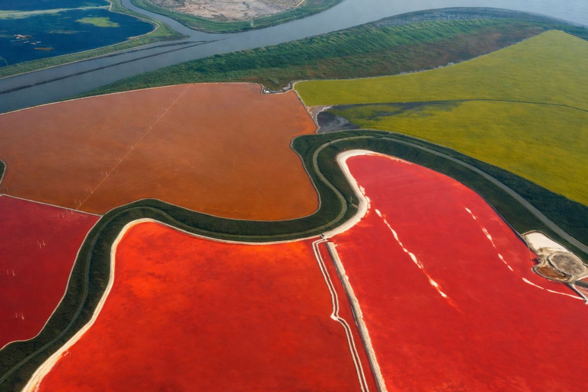
From The Airplane Windows, Salt Ponds Look Natural, But They Formed From 150 Years Of Industrial Evaporation That Replaced Marshlands In San Francisco Bay, Until Only 15% Remained In The 1960s; Now, A Public-Scientific Effort Breaches Levees, Monitors Sediments And Redraws The Coast Slowly, Without Erasing Essential Managed Ponds.
Ponds in shades of red, orange, and green stretch like geometric stripes as the plane approaches San Francisco. From many meters up, the scene looks like an abstract palette and, for a few seconds, gives the impression that the coast has always been this way.
But these ponds did not come into being as a landscape: they were built as infrastructure. And what today becomes a “postcard” from above is also the trace of a transformation that removed most of the marshes from the bay and paved the way for one of the largest wetland restoration projects in the United States.
When The Bay Was A Living Marsh And The Shore Breathed With The Tides

Before the edge of San Francisco Bay was sliced by levees and dams, the shoreline functioned as a living frontier.
-
Luxury hotels are taking the competition to the ocean and transforming billion-dollar yachts into exclusive extensions of their brands for a new premium tourism.
-
A Brazilian city produces 120,000 pairs of shoes per day and dominates the footwear industry, accounting for 16.5% of national production and helping Ceará capture 24.3% of the Brazilian market even under external pressure.

-
A millionaire wanted a mansion in Florida, found a protected bird, and is now trying to overturn environmental protection, impacting more than 1,200 species, to avoid a fine of $118,000.
-
Brazilian city next to Natal holds the massacre of 1645, gathers the first saints of Brazil, and concentrates a cultural, religious, and popular heritage that many people still ignore.

There are records citing something like 200,000 acres of marsh surrounding the bay before the gold rush, and also references to 200,000 acres in historical descriptions of the same landscape, figures that appear in different units over time.
In both cases, the message is the same: it was a vast system that rose and fell with the tides, featuring reeds, mudflats, and winding channels.
For the Aloney people, these marshes were home, not “wasted land.” Salt was harvested from natural crusts left by evaporation pools, boats were used for fishing, and life was organized by the rhythm of the seasons.
The marsh filtered water, buffered storms, and sustained an entire chain of food and shelter. Every winter, flocks of migratory birds descended there to rest and feed, following the Pacific route, with journeys documented from Alaska to Patagonia.
The Century Of Salt, The Geometry Of Levees And The Hunger For Land
In 1854, the first commercial saltworks were established along the bay’s edge. The beginning was small, with shallow ponds and wooden levees, but growth quickly accelerated. By 1868, there were already 18 companies operating along those shores.
In the following decades, the scale shifted from “production” to territorial reshaping: by the 1930s, almost half of the South Bay would have been colored and flooded for salt production, with Leslie Salt, described as the largest in the industry, consolidating smaller operations and sculpting over 25,000 acres for the salt chain, nearly half of the South Bay.
But it was not “just salt.” The ambition for land accompanied the advance of industrial ponds. Fill and construction pushed the bay back: Foster City emerged in the 1960s built entirely on material dumped from former marshes, and areas like San Mateo, Redwood Shores, and even runways of the international airport were cited as examples of edges redone in concrete and subdivisions.
By 1950, about 50,000 acres of coastal area subject to the tides remained, roughly a quarter of what the bay once had, while the rest became evaporation ponds, urban blocks, and industrial zones.
Three Women, A Map On The Kitchen Table And The Barrier That Halted The Fill

The change in direction did not begin in a laboratory or office.
In 1961, a map printed in Oakland and published by the Tribune reached kitchen tables in the East Bay area: the dark ink “swallowed” open water and left only a strip, with the warning that, if filling continued, San Francisco Bay could shrink to a river by around 2020. For most, it was just another piece of news. For three neighbors, it became a trigger.
Kay Kerr, Sylvia McLaughlin (also spelled McLaughlin in reports) and Esther Gulick (also known as Gulick) gathered with coffee, a map, and notes on the backs of envelopes.
From there, the Association to Save the Bay was born, and the central idea was simple and rare: ordinary people could say “no” to the erasure of an entire landscape. Public pressure shifted the debate from “how much more can be filled” to “how much needs to be protected.”
In 1965, a legislative turn came with the law referred to as Makate Petus (the name appears with variations), which created the Bay Conservation and Development Commission, the BCDC, a regulatory agency with real power. For the first time, filling the bay required a permit.
Plans to turn marshes into parking lots or neighborhoods became stalled. In 1969, the BCDC became permanent, with authority over nearly 70% of the shoreline, and even then-Governor Reagan signed the extension, described as a rare moment of bipartisan consensus. The marsh, battered, gained time, and time became the condition for any future restoration.
2003: 15,000 Acres Return To The Public And Restoration Comes Out Of Discourse
In 2003, the bay gained something it hadn’t seen in over a century: a concrete second chance. About 15,000 acres of ponds, previously private, passed into public trust when Cargill, cited as the last large remaining salt company, agreed to sell.
The price was US$ 100 million, in a deal that did not fit the mold of “real estate,” as appraisers pointed out that the land could be worth double if ever zoned for development.
The purchase was only made possible through coalitions and funds from multiple sources: US$ 72 million from the state of California, US$ 8 million from federal agencies, and US$ 20 million raised by private foundations. Senator Diane Feinstein emerged as a key player for having held meetings, mediated agreements, and sustained pressure for everyone to stay at the table.
The scale is difficult to imagine, described as the size of Manhattan, just made of levees, ponds, and marshland memory. And from there, the question shifted from “how to stop” to “how to bring back.”
How The Bay Tries To Reconstruct Itself: Adaptive Management, Tides Working And Painful Choices
Restoring at this scale required accepting that no one controls everything. Instead of designing a “perfect marsh,” scientists and engineers adopted a more than 100-page adaptive management plan, based on phases, monitoring, and constant adjustments.
The land was not a blank canvas: some ponds had salt crusts nearly 60 centimeters thick; others would be tainted with mercury linked to the rushed gold rush mining; and some areas sank to the point where the tides wouldn’t reach without careful planning. The project does not promise a straight line: it promises to measure, make fewer mistakes, and correct quickly.
The first operational milestone cited occurred in 2006, in Eden Landing, near Hayward, when a team opened a breach in the levee and the bay water returned to flood an old tank. The energy from the tides brought fine sediments, depositing mud and slowly raising the bottom, sometimes by an inch or more per year.
Without excavators shaping the channels, the water opened new creeks and reshaped bends where salt flats once existed. Native plants like salicornia and cordgrass reappeared, carried by the tides, seeded by birds, or simply returning when conditions ceased to be hostile.
The return of life was not limited to vegetation. Field monitoring recorded the salt marsh harvest mouse, described as a thumb-sized survivor, reappearing in restored areas, and Ridgeway rails once again calling for the channels and nesting in the dense vegetation that didn’t exist two seasons prior.
At the same time, a dilemma arose that changes the project’s design: not all ponds should become tidal marsh. Some artificial areas became critical habitat for specific species, like the “snowy plover,” described as a pale shorebird that nests in dry, open plains, precisely the kind of bare and salty terrain left by the salt industry.
Other birds rely on shallow, managed ponds for feeding during migrations, requiring adjusted water levels to mimic natural cycles. The desired outcome is not “going back in time,” but rather building a mosaic that maximizes life with difficult concessions, pond by pond.
The Clock Towards The 2050s And The Risk Of The Sea Erasing What Has Returned
So far, the progress described is significant and, at the same time, partial: about 3,300 acres have been opened to the tides since the first breach in Eden Landing, while approximately 15,100 acres are still awaiting restoration, in a process projected to extend until the 2050s.
Teams traverse levees and mudflats, track sediments, count stems, log the return of fauna, and adjust the plan as the data show where the bay responds faster and where it lags behind.
The problem is that new threats are already running parallel to the timeline. Cited projections indicate that the bay could rise by 1 to 4 feet by the end of the century, and that changes everything: for the new marshes to survive, they need to accumulate enough sediments to remain above the encroaching water. If they don’t keep up, decades of work could disappear beneath waves.
The legacy of mercury also remains an operational risk, as breaching levees can stir up old sediments, requiring monitoring of fish and birds and readiness to change the plan if contamination spreads.
Restoration becomes a permanent conversation between tides, climate, and human decisions, with patience as the central technology.
In the end, the ponds that the passenger sees on descent are not just a pretty “before and after.” They are a reminder that the bay was shortened by politics and profit, defended by social organization, and is now being rebuilt through a work combining science, regulation, and imperfect choices.
Every winter and spring, over a million birds descend upon the region, drawn by a system that, for them, is not a landscape: it is survival.
When you see a “beautiful” landscape from above, do you usually imagine what existed there before, or do you only realize when someone tells the story? And, if it were with the ponds near your city, would you accept keeping some of them as managed ponds for certain species, even knowing that the original marsh won’t return whole, or would you prefer to try to restore everything to the fullest, no matter the cost in concessions?


-

-

-

-

-

20 pessoas reagiram a isso.