 Portuguese
  English
  Spanish
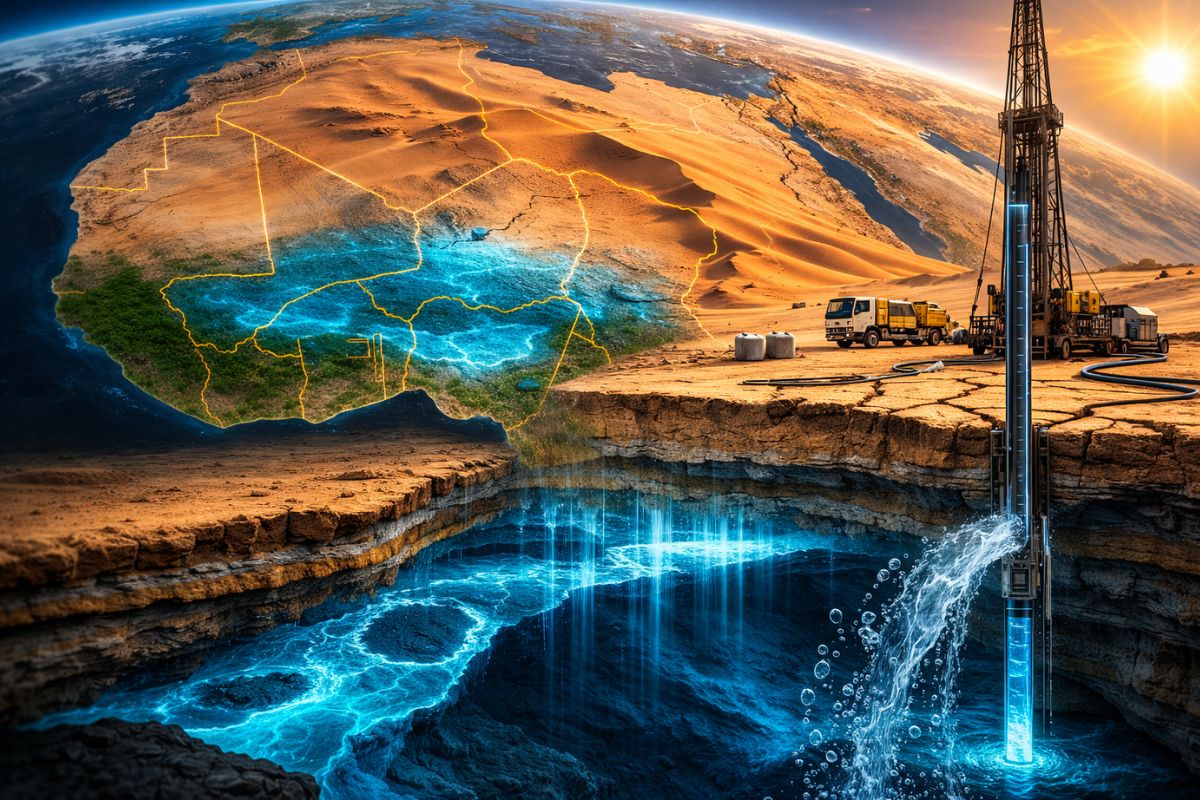
The Largest Known Fossil Aquifer The Nubian Sandstone Aquifer System Spans Four Countries Beneath The Sahara Holds Groundwater In Volumes Comparable To 500 Years Of Nile Flow And Forces Egypt Libya Chad And Sudan To Plan With The IAEA How To Use A Reserve That Is Not Replenished.
The largest known fossil aquifer on the planet is hidden beneath the Sahara and holds a mass of groundwater so vast that its reserves are equivalent to about 500 years of flow from the Nile River. Spread across Egypt, Libya, Chad, and Sudan, the system has become a central piece for countries that need to sustain supply, agriculture, and territorial expansion in arid regions.
This abundance, however, comes with a harsh limitation. The water stored in this system is fossil, ancient, and not an active part of the current hydrological cycle, which means it cannot be replenished like a regular reserve. In practical terms, it is a strategic stock that can be used but not renewed, which is why the IAEA and other partners have started treating it as a topic of science, politics, and international cooperation at the same time.
A Continental Reservoir Beneath The Sahara

The Nubian Sandstone Aquifer System extends beneath four countries in northeastern Africa and occupies a continental-scale underground band below the Sahara.
-
In a flooded well, archaeologists found a 1,700-year-old Roman egg that still contains clear and yolk intact inside the very thin shell.

-
Something is happening around the Earth: Inside the huge explosion of fireballs in 2026

-
A hot air bubble coming from Argentina expands over Brazil, causing thermometers to exceed 38 degrees with a thermal sensation of 40 degrees in late March, affecting 6 states at once.

-
The radish leaf that almost everyone throws away has more polyphenols, flavonoids, and fiber than the consumed root, and a 2025 study showed that the leaf contains compounds that protect the intestine, combat inflammation, and may inhibit the growth of cancer cells.


The dimension of the reserve helps to understand why the system attracts so much attention: according to the database used in the international project, its volume is approximately equivalent to 500 years of Nile flow and is 20 times larger than the Great Lakes of North America.
This is not a regional reservoir, but a gigantic water structure buried beneath one of the driest areas on the planet.
It is precisely for this reason that the largest fossil aquifer has gained geopolitical weight. Egypt and Sudan have always depended heavily on the Nile, but pressure on the river has increased with population growth, agricultural expansion, and industrialization.
Meanwhile, Libya and Chad do not have a large equivalent river and face an even more direct scarcity of surface resources.
In this context, the aquifer beneath the Sahara has come to be seen as a priority reserve for future demands and development planning.
The special condition of this reserve lies in its fossil nature. The groundwater stored there is described as abundant but irreplaceable.
It can be used once, like oil, because its natural replenishment does not keep pace with human extraction.
This characteristic completely changes the way consumption is thought of: it is not about capturing and waiting for the return, but rather about managing a stock that, once reduced, does not easily come back.
That is why the largest fossil aquifer is not just an impressive hydrogeological discovery. It is a limit boundary. The larger the reserve, the greater the temptation to treat it as infinite.
And that is precisely the risk that the IAEA is trying to avoid by supporting measurements, models, and cooperation instruments among the countries that share the system.
Why Egypt And Libya Are Increasingly Looking Down

The pressure on this groundwater varies between countries, but follows the same logic: the surface no longer delivers everything that was necessary.
In Egypt, the need to support the development of new cities in desert areas far from the Nile drives the gaze downwards, toward the underground system.
In Libya, the aquifer appears as a basis for large-scale supply projects, including the so-called Great Man-Made River Project, aimed at bringing fresh water to Tripoli.
This growing dependence alters the strategic weight of the largest fossil aquifer.
What was once seen as a hidden reserve for eventual use is now treated as a central asset for water security.
For Egypt, this means thinking beyond the Nile corridor. For Libya, it means sustaining regions that do not have a comparable river course.
In both cases, the system beneath the Sahara ceases to be a scientific curiosity and becomes invisible infrastructure.
The crux of the problem is that this movement may accelerate extraction even before there are complete answers about the dynamics of the aquifer.
How much can be extracted? How long will it last? Where should new wells be drilled? These are questions that were still open when the international project was described.
That is why the discussion about the largest fossil aquifer is not limited to quantity but also involves the speed and manner of usage.
There is also a transboundary dimension. If a country expands exploration in a connected area of the system, the effects may not stop at the border.
This is one of the reasons why the IAEA and its partners insist on cooperation.
A shared aquifer requires shared management, especially when the water is fossil and the margin for error is much smaller than in systems with active recharge.
What The IAEA Is Trying To Discover With Isotopic Hydrology
To reduce uncertainties, the IAEA and other international organizations have begun using isotopic hydrology in the study of the Nubian Sandstone Aquifer System.
The goal is to answer critical questions regarding the age of the water, the duration of reserves, the impacts of human actions, and the overall behavior of the system.
In such a deep and extensive aquifer, collecting sufficient hydrological information through conventional methods is difficult, and thus the combination of isotopic analysis and computational modeling gains strategic importance.
The joint project of the IAEA, UNDP, and GEF was launched in 2006, initially focusing on observation and data collection.
One of the central results was the development of a computational model capable of simulating how water moves through the aquifer and how its levels may change over time.
This model acts as a kind of anticipation of the future of the system, allowing the testing of scenarios and measuring risks before they turn into overt crises.
According to the project description, modeling helps identify potential problems and their origins. This is especially relevant in a subterranean reservoir of this scale because damage can advance silently for years before becoming visible on the surface.
The IAEA specifically enters to reduce this operational blindness, providing technical instruments to help Egypt, Libya, Chad, and Sudan better understand the consequences of their own use.
The importance of this goes beyond science.
The very design of the project’s next phases aims to expand the technical aspects of the model to engage with public policies and institutional structures related to the management of the system.
In other words, the knowledge produced by the IAEA does not just aim to explain the largest fossil aquifer, but to influence how it will be governed.
How Long Can This Reserve Last And Why Does It Matter
The database used in the project does not provide a final date for the exhaustion of the system but makes it clear that this possibility exists.
At some point in the future, the aquifer could be exhausted, making it even more important to understand its dynamics and manage its extraction.
This uncertainty is perhaps the most sensitive point of the discussion. The reserve is gigantic, but not eternal.
And the more it supports cities, farms, and industries, the greater the need for careful planning.
This is precisely where the largest fossil aquifer becomes a long-term issue for northeastern Africa.
The system can support socioeconomic development, urban expansion, and water security, but only if there is rational and equitable management.
The fundamental goal of the international project is precisely this: to build a way of use that does not turn the current abundance into a future crisis.
The four immediate objectives outlined for the joint effort reinforce this sense.
They include identifying transboundary threats, filling information gaps, developing a strategic action program, and establishing a framework for implementation.
It is not enough to know that the aquifer exists and is enormous. It is necessary to create mechanisms to decide who uses, how much is used, where it is used, and with what consequences for neighbors.


-

-

-

-

-

7 pessoas reagiram a isso.