 Portuguese
  English
  Spanish
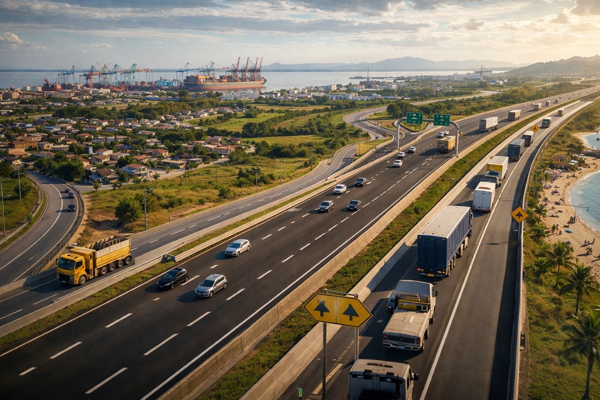
Largest Infrastructure Project in the South, the Duplication of BR-116/RS Reconfigures Logistics Corridor Between Guaíba, Camaquã, and Pelotas, Improves Urban Mobility at Crossings, Reinforces Road Safety in Critical Sections, and Integrates Neighborhoods, Rural Areas, Ports, and Tourist Attractions in the Gaucho State in Rio Grande do Sul While Strengthening Regional Connectivity
The largest infrastructure project in the South, the duplication of BR-116/RS between Guaíba and Pelotas, has been transforming the logistics corridor that connects the Porto Alegre Metropolitan Region to the ports of Rio Grande and Pelotas, changing the daily lives of entire cities along the highway.
On this date, residents of urban neighborhoods, rural communities, and tourist destinations began to feel more clearly the effects of the duplication of BR-116/RS on urban mobility and road safety, with duplicated lanes, side streets, and devices that separate local traffic from the heavy flow of trucks and buses.
How the Duplication of BR-116/RS Became the Largest Infrastructure Project in the South

The duplication of BR-116/RS between Guaíba and Pelotas was planned to relieve historical traffic bottlenecks and is now recognized as the largest infrastructure project in the South. The route connects the Porto Alegre Metropolitan Region to the southern half of the state and organizes the logistics corridor that links production areas to the ports of Rio Grande and Pelotas.
-
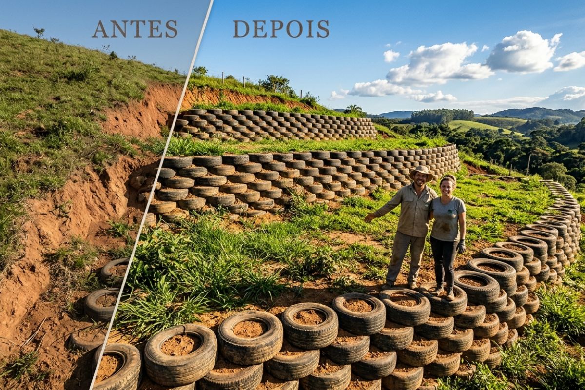
Couple shows how they built a retaining wall on their property using 400 old tires: sloped land turned into plateaus, tires are aligned, filled, and compacted with layers of soil, with grass helping in support and at almost zero cost.
-
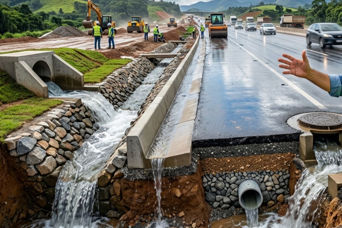
Engineer explains drainage during the rainy season: the difference between surface water and deep water, ditches, gutters, and water outlets on the road, as well as drains and drainage mattresses, to prevent erosion, aquaplaning, and flooding at the construction site today.
-
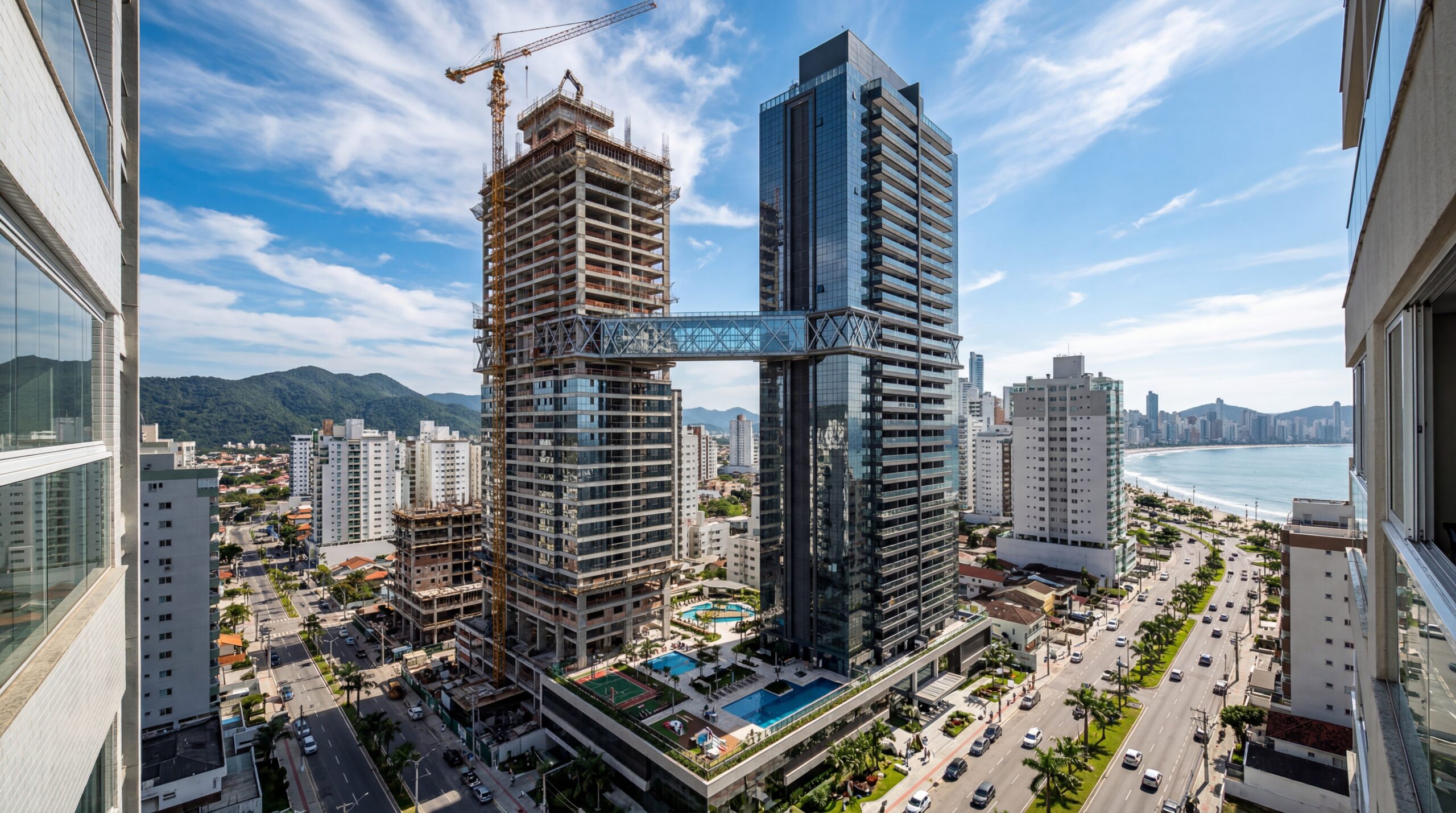
With 55 floors, 177 meters in height, a 15-meter walkway between the twin towers, ventilated facade, and 6,300 m² of leisure space, Ápice Towers already has one tower completed and another nearly at the top.
-
After nearly 50 years of neglect, BR-319 receives R$ 678 million to pave 340 km, gain a 320-meter bridge, and try to lift Amazonas out of the mud, the quagmire, and road isolation.
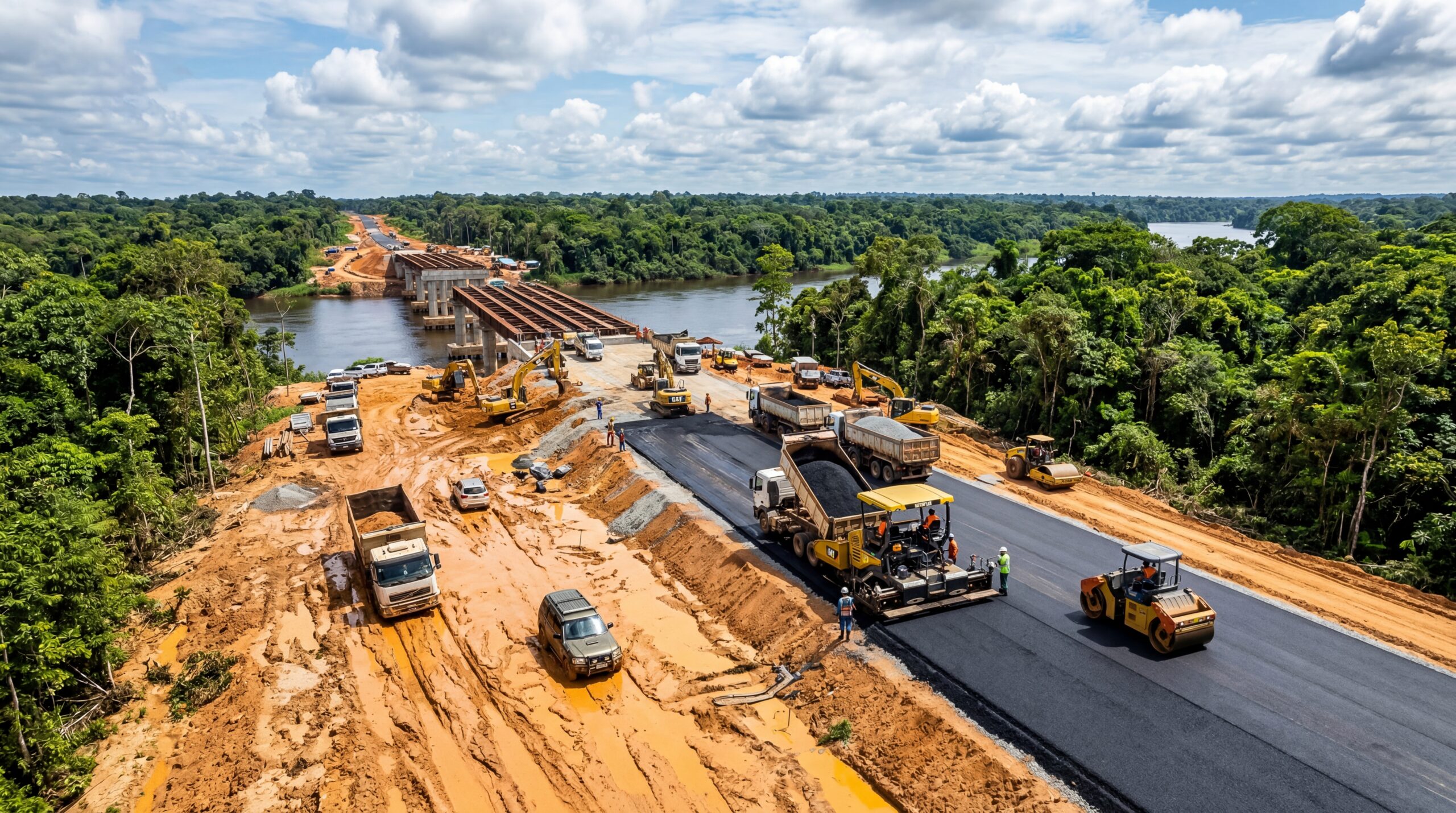

Along the highway, the largest infrastructure project in the South alters urban and rural routines, reduces travel time, and rebalances the relationship between freight trucks and light vehicles. Sections previously marked by dangerous intersections and improvised turns now feature additional lanes, central medians, and planned access points to support the growth of daily traffic.
Direct Impact on Urban Mobility of Cities Crossed by BR-116/RS
At urban crossings, the duplication of BR-116/RS was designed to improve urban mobility and separate local trips from long-distance traffic.
Side streets, marginal roads, and internal routes allow residents to circulate between neighborhoods, schools, businesses, and services without always relying on the main lane.
In cities like Guaíba, Camaquã, Cristal, São Lourenço do Sul, Turuçu, and Pelotas, urban mobility gains more predictable and safer routes, with fewer conflicts between trucks, buses, and passenger cars.
The largest infrastructure project in the South also reorganizes access to neighborhoods and rural areas, facilitating the transport of workers, students, and tourists along the entire roadway axis.
Road Safety Devices Reduce Conflicts and Accidents
Another central aspect of the project is road safety.
Overpasses at strategic access points, underpasses between neighborhoods, side streets, and physical barriers have been installed to reduce at-grade crossings, risky turns, and wrong-way incursions, especially in urban sections of BR-116/RS.
With these devices, road safety is treated as a structural part of the duplication of BR-116/RS, reducing the risk of head-on collisions, pedestrian accidents, and congestion at the most critical points.
The largest infrastructure project in the South also incorporates drainage and pavement systems that improve grip on rainy days, providing more stability to drivers who use the corridor daily.
Logistics Corridor Integrates Agriculture, Industry, and Ports in the South of the Country
The duplication of BR-116/RS consolidates a logistics corridor that connects farms, industrial hubs, and port terminals in southern Brazil.
The southern half of the state encompasses rice, soybeans, livestock, and agribusiness industries that rely on fast and reliable access to the ports of Rio Grande and Pelotas.
With greater fluidity, the logistics corridor shortens the distance between rural areas, storage centers, and urban zones, reducing travel time and transport costs.
This increases the competitiveness of Gaucho companies in national and Mercosur markets and strengthens the perception that the largest infrastructure project in the South is crucial for the flow of regional production.
Challenges, Next Steps, and Lasting Effects of the Largest Infrastructure Project in the South
Even with significant advancements, the duplication of BR-116/RS still requires constant monitoring of access points, turns, and crossings to ensure efficient urban mobility and road safety along its entire length.
City halls, the federal government, and public service concessionaires need to adjust signage, lighting, and connections with neighborhoods and tourist areas.
In the long run, the largest infrastructure project in the South is likely to establish a new standard for urban mobility and road safety along the axis between Guaíba and Pelotas, while maintaining the logistics corridor functioning with greater predictability.
The way each city adapts to the new BR-116/RS will determine how much of this transformation translates into quality of life, attraction of investments, and sustainable growth for the state.
And you, have you felt any changes in your routine because of BR-116/RS?


Seja o primeiro a reagir!