 English
  Francês
  Alemão
  Italiano
  Japonês
  Norueguês
  Portuguese
  Spanish
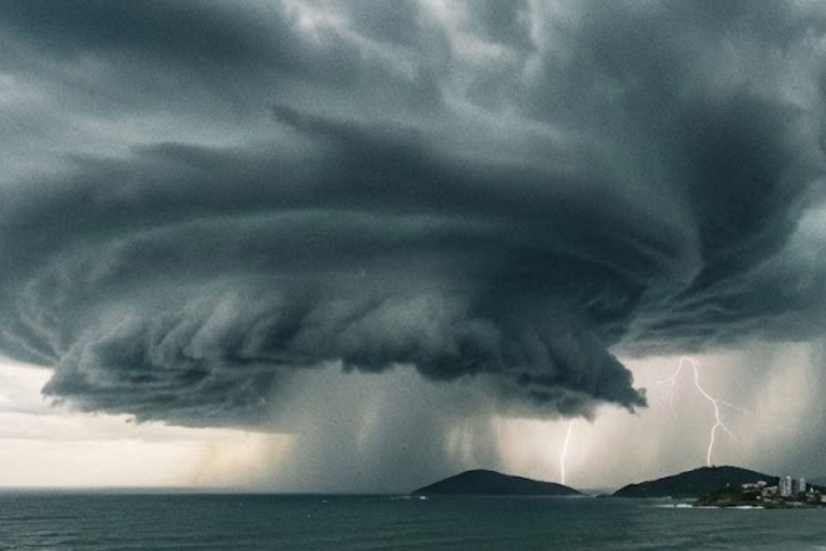
Meteorology Indicates That The Cyclone Of The Year, Described As A Mini Hurricane, Is Organizing Near The South Of Brazil, But The Main Area Is In Uruguay. For Santa Catarina, There Is No Direct Aim. Even So, The Cold Front Associated With It Advances And Could Bring Instability, Isolated Storms, Strong Winds, And Intense Rain.
A mini hurricane begins to form and is already alerting the South of Brazil, with the phenomenon relatively close but with its main influence concentrated in Uruguay. The meteorology assessment is that there is nothing to “come to us” as a direct impact of the cyclone, and that Santa Catarina is not in the aim of the system.
This does not mean an absence of effect in the South of Brazil. The influence occurs indirectly, through a cold front associated with the cyclone offshore, which advances through the region and opens up areas of instability. The scenario may include isolated storms, with a localized risk of strong winds, intense rain over a short period, and electrical discharges, especially between Sunday and Monday, although isolated storms have already been observed since this Thursday, the 8th.
What Is Forming And Why The Alert Was Triggered
The first cyclone of the year, described as a kind of mini hurricane, is forming to the south and is causing concern precisely due to its proximity to the South of Brazil.
-
At just 14 years old, a boy creates a system without energy, using steel pipes buried in the ground, that irrigates seedlings with moisture from the air, to combat the water scarcity threatening reforestation in northern China.

-
Anti-tank mines appear near a missile base in Iran, causing fatalities and raising suspicion of a new move to block underground launchers.
-
Contaminated water from uranium threatens mining areas, and Chinese scientists have created a solar-powered living filter that could change environmental decontamination.

-
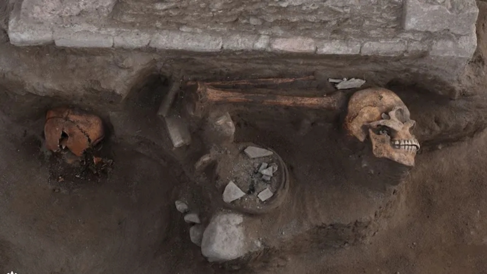
Archaeologists find in Mexico a sacrifice altar over 1,000 years old, surrounded by skulls, human bones, and signs of rituals from the Toltec Empire.

Authorities connect the alert because the system is relatively close, which naturally raises attention to rapid changes in weather and the potential for associated instability.
At the same time, the meteorology points to a clear delineation of the main risk. The central area of the cyclone’s activity is in Uruguay, not in Brazilian territory.
This distinction is crucial to understanding the forecast: the center of the phenomenon would not advance directly over Brazil, but its presence in the ocean is enough to reorganize the atmospheric patterns arriving in the South of Brazil.
Santa Catarina Out Of Direct Aim, But With Influence On The Weather
Meteorology dismisses any direct impact on Santa Catarina. Meteorologist Piter Scheuer explained that there is nothing from the cyclone aimed at the state, and that the only point directly in the sights is Uruguay.
The reading is straightforward: it is not a system entering Santa Catarina, but a system that, by being active and connected to the ocean, alters the behavior of the air masses around.
This difference can be confusing because, in practice, residents feel changes in the weather even without the cyclone “passing” over the state map.
That is why the operational focus shifts from the center of the phenomenon to what it pulls and organizes in the background, especially the cold front that connects to this presence in the ocean.
The Cold Front Associated With The Cyclone And The Impact On The South Of Brazil
The central point for the South of Brazil is the cold front generated by the cyclone offshore. Meteorology describes this configuration as common and classic: the cold front is connected to the presence of the cyclone in the ocean, not to a direct action of the phenomenon over Brazilian land.
This cold front advances across the South of Brazil and creates areas of instability. In practice, this means that the weather can vary more abruptly, with rain cores forming and moving unevenly, not necessarily affecting all cities in the same way or with the same intensity.
It is in this type of pattern that isolated storms appear, those localized events that can be strong in one area and practically nonexistent in another.
What Changes In Practice: Instability And Isolated Storms
When meteorology speaks of instability in the South of Brazil, the highlight is not on continuous and uniform rain, but on favorable conditions for episodic occurrences.
The described risk includes strong winds, intense rain over a short period, and electrical discharges, a typical combination of isolated storms during the summer.
The “localized” nature is important. It does not eliminate the risk; it simply indicates that it may concentrate in specific areas and during short windows, requiring attention precisely because the intensity can surprise when instability organizes quickly.
Most Sensitive Window Between Sunday And Monday
The cold front begins to affect the weather in the South of Brazil between Sunday and Monday, which is the window identified as most sensitive to the presence of instability associated with the system in the ocean.
During this period, the risk of isolated storms and more intense episodes may increase, especially due to the very dynamics of the cold front’s advance.
Still, the scenario does not start from scratch during this time.
Since this Thursday, the 8th, isolated storms have already been recorded in the South of Brazil, reinforcing that the atmosphere is already in instability mode, and that the cold front associated with the cyclone may act as an additional organizing element for the weather.
Why The Phenomenon Worries Even Without Direct Impact In Brazil
The center of the cyclone not acting directly in Brazilian territory reduces the risk of a frontal impact, but does not eliminate the effects on the South of Brazil.
Concerns exist because a cyclone offshore can function as a motor for reorganization, capable of intensifying the entry of colder air through the cold front and favoring the formation of unstable areas.
In other words, the phenomenon is more concerning not for the cyclone’s “direct touch” but for the set of conditions it helps to assemble.
The alert is maintained based on the possibility of intense and localized episodes, especially when the cold front meets an environment already conducive to isolated storms.
What To Observe In The Coming Days In The South Of Brazil
With the forecast of associated instability, the more objective focus to follow in the South of Brazil involves three fronts, all already highlighted by meteorology: the evolution of the cyclone with main activity in Uruguay, the advance of the cold front connected to the system in the ocean, and the occurrence of isolated storms with localized risk.
The combination of strong winds, intense rain over a short period, and electrical discharges is the type of situation that can appear during short windows and with irregular distribution.
Do you prefer to receive alerts like this in advance, even when the direct impact on the South of Brazil is ruled out, or do you think that increases anxiety unnecessarily?


-

-

-

-

-

-

80 pessoas reagiram a isso.