 Portuguese
  English
  Spanish
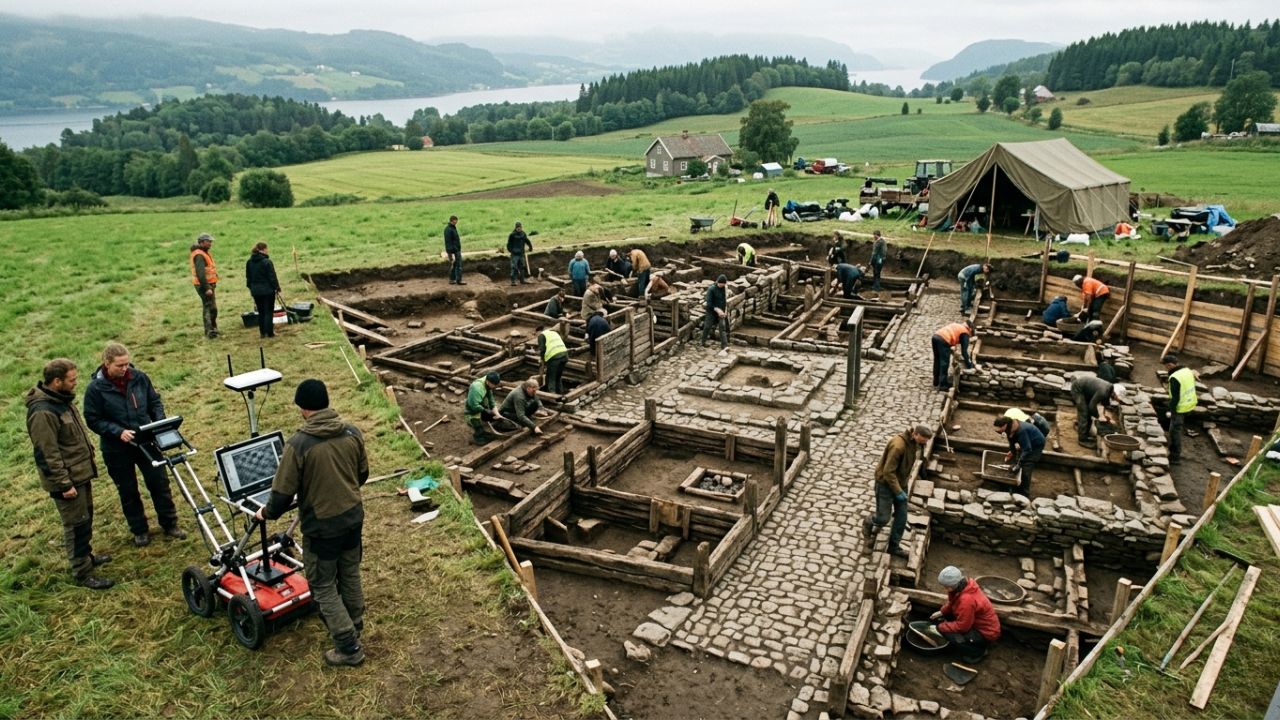
Ground-penetrating radar reveals buried medieval city in Norway and excavations confirm preserved streets, houses, and structures after centuries treated as legend.
In 2025, archaeologists from the Norwegian Institute for Cultural Heritage Research (NIKU) confirmed the existence of the ancient medieval city of Hamarkaupangen, located in the Hamar region of Norway, after a combination of ground-penetrating radar technology and archaeological excavations revealed preserved urban structures beneath the soil. The discovery was officially announced by the institute itself and details how an area that had been treated as a legend or historical hypothesis for centuries has been substantiated with concrete physical evidence.
The confirmation represents a significant advancement in Scandinavian archaeology, as it validates fragmented historical records that mentioned the existence of a medieval urban center in the region, but had never been confirmed through direct excavations.
Ground-penetrating radar identified streets, buildings, and urban patterns buried beneath the field
The first concrete evidence emerged with the use of ground-penetrating radar (GPR), a technology that allows mapping of underground structures without the need for immediate excavation. The survey revealed geometric patterns consistent with urban occupation, including linear layouts interpreted as streets, rectangular areas associated with buildings, and internal divisions suggesting planned spatial organization.
-
In the United States, a valley 86 meters below sea level has reached 56.7°C and remains the place with the highest air temperature ever recorded on Earth, a direct result of a terrain that traps heat between high mountains in the midst of the desert.

-
Goodbye clothes with odors from use: Samsung’s device uses high-temperature steam, eliminating up to 99.9% of bacteria, removing dust mites, and neutralizing odors directly in the wardrobe without the need for washing.

-
Embraer arrives in Mexico with 7 new E190-E2s in 2026, after 5 jets have already been delivered, while Mexicana surpasses 1 million passengers, plans a fleet of 20 aircraft, and expands strategic routes across the country.

-
China is not joking around and is secretly expanding its nuclear weapons infrastructure: a giant dome the size of 13 city blocks, 600 warheads, destroyed villages, and a modernized military network in record time in China, says CNN.


These data indicated the presence of a relatively complex urban structure, something unusual for areas where there were no visible traces on the surface. The analysis of the ground-penetrating radar was essential in directing excavation points, reducing the need for invasive interventions and increasing the accuracy of archaeological work.
Excavation confirmed wooden planks, floors, and preserved structures
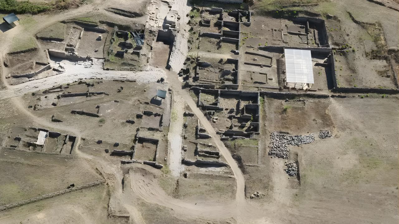
After the mapping stage, the archaeologists began targeted excavations in the areas identified by the ground-penetrating radar. It was at this moment that physical evidence emerged confirming the existence of the city. Among the finds were preserved wooden planks that formed floors, remnants of structural walls, and layers of human occupation associated with urban activity.
The preservation of organic materials, such as wood, was possible due to the specific soil conditions that limited decomposition over the centuries. These elements confirmed that the site was not just an isolated settlement, but part of an organized urban structure.
The medieval city was part of an important religious and commercial center
Hamarkaupangen was associated with the city of Hamar, which became an important religious center in medieval Norway, especially after the establishment of the diocese of Hamar in the 12th century. Historical records indicate that the region had:
- Commercial activity;
- Presence of religious structures;
- Connections with local and regional routes.
The archaeological discovery reinforces the idea that Hamarkaupangen functioned as an active urban hub, possibly linked to trade and local administration.
Why the city disappeared and became a legend for centuries
The absence of visible traces over the centuries led many historians to question the actual existence of the city. Unlike other medieval centers, Hamarkaupangen did not leave apparent ruins above ground.
Among the factors that may have contributed to this disappearance are the gradual abandonment of the area, the degradation of wooden structures, and changes in land use over time. Without direct material evidence, the city remained for centuries in the realm of hypotheses, supported only by written records and local traditions.
GPR technology changes the way to investigate lost cities
The use of ground-penetrating radar was crucial for the rediscovery of Hamarkaupangen. This technology has been increasingly used in archaeology as it allows the identification of underground structures without the need for extensive excavation.

Photo: Håvard Hegdal, NIKU.
The GPR works by emitting electromagnetic waves into the ground and analyzing the return patterns, which allows detecting variations indicating the presence of buried objects or structures.
In the case of Norway, this approach was essential to reveal an entire city without any visible signs on the surface.
Discovery reinforces the role of scientific archaeology in historical validation
The confirmation of Hamarkaupangen demonstrates how modern archaeology combines technology and traditional methods to validate historical records. The case highlights that:
- Not all medieval cities leave visible traces;
- Historical documents can be confirmed centuries later;
- New technologies expand investigative capacity.
This integration between history and science allows for the reconstruction of scenarios that were previously considered uncertain or speculative.
Find contributes to understanding medieval urbanization in Scandinavia
The discovery also broadens knowledge about the formation of cities in Scandinavia during the Middle Ages. The presence of an organized urban structure suggests that the region had more complex levels of development than previously thought.
This includes aspects such as urban planning, economic organization, and the interaction between religious and commercial centers. These elements help reconstruct the functioning of medieval cities in northern Europe.
What the discovery reveals about buried cities that have yet to be found
The rediscovery of Hamarkaupangen raises the possibility that other cities or historical settlements may be completely hidden beneath the soil, without any superficial evidence. This reinforces the importance of using technologies such as ground-penetrating radar, remote sensing, and geophysical analysis. These tools allow for the investigation of extensive areas with precision and open new fronts for archaeological research.
The confirmation of an entire medieval city after centuries of doubt shows that archaeology still has the potential to reveal complete structures hidden beneath our feet. With the advancement of underground detection technologies, new discoveries may arise in regions where there is currently no visible indication of ancient occupation.
Now the question is straightforward: do you think there are still entire cities buried waiting to be revealed? Share your opinion in the comments.


Seja o primeiro a reagir!