 Portuguese
  English
  Spanish
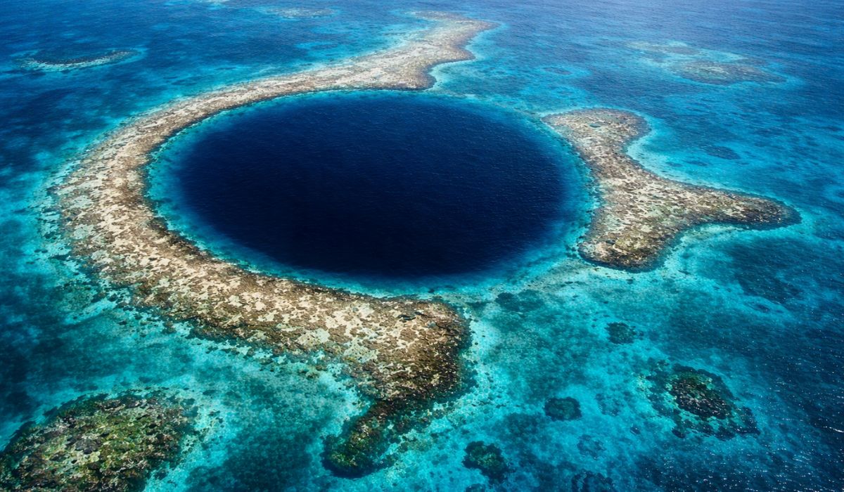
Submerged Formation in the Caribbean Brings Extreme Depths, Traces of Ancient Limestone Caves, and Rare Conditions of Geological Preservation, Making the Great Blue Hole One of the Most Studied and Observed Spots by Divers and Researchers in the Region.
At the center of Lighthouse Reef Atoll, about 70 kilometers from the coast of Belize, the Great Blue Hole concentrates features that explain its international prominence: large dimensions, unique geological origin, and a submerged interior that preserves signs of when the structure was still in a dry environment.
The marine sinkhole has a diameter of about 300 meters, a depth between 124 and 125 meters, and is part of the Belize Barrier Reef Reserve System, recognized by UNESCO as a World Heritage Site since 1996.
From above, the formation appears as a dark blue circle surrounded by the shallow waters of the reef.
-
China is building a city in Brazil: a complex with an investment of R$ 5.5 billion comes to light, but allegations involving workers draw attention.
-
While Argentina buys old war equipment, Brazil is keeping an eye open and joins the select group of nations with advanced military technology by investing $5.2 billion, producing 36 Gripen fighters in the country, and reducing operational costs.

-
Brazil on alert? Why invading Brazil is a NIGHTMARE for the USA: 8.5 million km², 213 million inhabitants, Amazon covering 60% of the territory, trillion-dollar war, and resistance that even 13,000 aircraft could not control.

-
How to build a floating island from scratch with reeds, giant blocks, and stakes in the lake in a process that needs to be repeated almost every day.


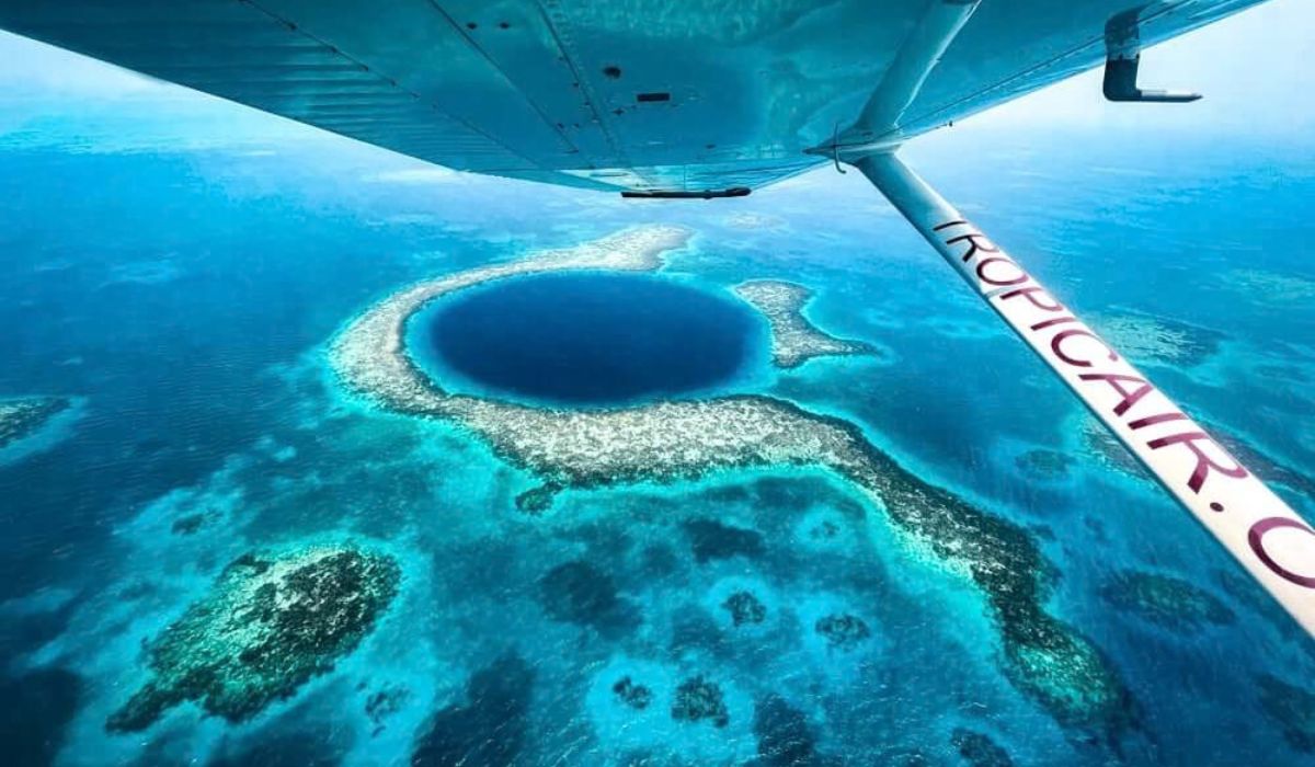
The image helped popularize the location in the Caribbean, but scientific interest is primarily linked to its formation.
Researchers point out that the blue hole functions as a natural record of sea level variations, glacial phases, and the geological evolution of the region.
Great Blue Hole in Belize: Location and International Relevance
The Great Blue Hole is located in Lighthouse Reef, an atoll situated in the territorial sea of Belize.
International notoriety grew after Jacques-Yves Cousteau’s visit in 1971 when the expedition of the vessel Calypso helped diffuse the location and reinforce the interpretation that it is a karst limestone formation created before the rise of sea level.
The tourist projection came later, but scientific relevance was already recognized.
This is because the blue hole did not form already submerged.
According to geological studies, the structure corresponds to part of a cave system that existed on land before the flooding caused by the rise of the ocean.
This point helps to explain the presence of formations that, at first glance, do not match the seafloor.
In expeditions and research carried out at the site, divers and scientists have identified large speleothems, including stalactites, at depths now completely submerged.
As these structures develop in caves with the presence of air, they are treated by specialists as evidence that the cavity spent long periods above sea level.
How the Great Blue Hole Formed Over Time
The most accepted explanation for the origin of the Great Blue Hole is related to sea level fluctuations during the Quaternary.
During glacial phases, when much of the water remained trapped in polar ice caps, the ocean receded and exposed areas that are now submerged.
In this scenario, the infiltration of water into limestone rocks favored the dissolution of the material and the formation of caves.
Later, with the melting of the ice and the rise of sea level, these cavities were flooded.
Subsequently, part of the ceiling collapsed, giving rise to the circular opening visible today.
Research frequently cited about the site indicates at least four main phases of formation in a dry environment, with approximate ages of 153,000, 66,000, 60,000, and 15,000 years.
Studies have also recorded stalactites tilted about 5 degrees off vertical.
For researchers, this tilt may be associated with the tilting of the plateau before the definitive flooding of the structure.
This data reinforces the assessment that it is not just a depression on the seafloor, but the remnant of an ancient cave preserved underwater.
Subsurface Stalactites Reveal the Geological Past of the Crater
The stalactites found inside the Great Blue Hole are considered one of the main pieces of evidence of the geological history of the formation.
This type of mineral structure develops in an aerial environment, from the continuous dripping of carbonate-rich water over limestone rocks, in caves with air circulation.
Therefore, the presence of these formations at great depths is used by researchers as evidence that the area has been exposed.
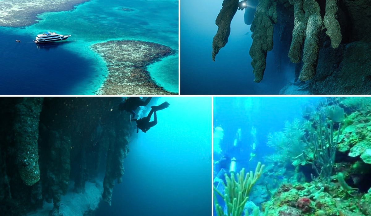
The interior of the sinkhole preserves ledges, chambers, and large rock structures associated with this geological past, especially in areas where the walls cease to be continuous vertical and begin to reveal ancient cavities.
Diving reports and technical descriptions record the presence of these formations in deeper zones of the descent.
There, the landscape changes profile and the interior of the crater begins to present features of a flooded cave.
In this context, the diving interest in the location focuses less on the observation of corals and more on the geology preserved in the interior of the structure.
Diving in the Blue Hole Requires Experience and Planning
The Great Blue Hole is associated with deep diving, which requires specific training.
Specialized operators and materials aimed at the activity emphasize the need for advanced certification, rigorous descent planning, and control of bottom time.
Additionally, the depth imposes physiological restrictions known in advanced technical and recreational diving.

The combination of rapid descent, reduced bottom time, and programmed return makes the operation more complex than conventional dives conducted in shallow reefs.
The fame of being a “ship eater” associated with the location is linked to the strength of ocean currents and the tidal regime in the atoll region, in addition to reports about sunken vessels around the shallow reef that surrounds the formation.
Inside the blue hole, the distribution of marine life changes according to depth and the chemical conditions of the water.
Studies indicate that, in deeper layers, the water has a very low oxygen content and, below certain levels, anoxic conditions, preventing the presence of most complex marine life.
Therefore, the highest concentration of marine life is found in the shallower and well-oxygenated layers, while the deep environment of the blue hole becomes progressively more hostile to complex fauna.
Deep Layers and Sediments Preserved at the Bottom of the Crater
The expedition conducted at the end of 2018, involving Richard Branson and Fabien Cousteau, produced one of the most detailed surveys ever conducted at the site.
The work included three-dimensional sonar mapping and helped describe the internal structure of the Great Blue Hole more accurately.
Among the most cited findings is the identification of a layer of hydrogen sulfide at about 90 meters depth, associated with anoxic conditions below that level.
In practice, this means that the deep water becomes dark, with little or no dissolved oxygen, which prevents the presence of most complex marine life.
This feature also explains the scientific interest in the sediments deposited at the bottom of the crater.
In anoxic environments, these materials tend to suffer less biological disturbance, which favors the preservation of environmental records over time.
Recent research with sediment cores taken from the blue hole has been used to reconstruct the history of tropical cyclones and other environmental variations in the region over centuries and millennia.
For scientists, this type of record helps understand how extreme climatic events have recurred in the Caribbean during different periods.


-

-

4 pessoas reagiram a isso.