 Portuguese
  English
  Spanish
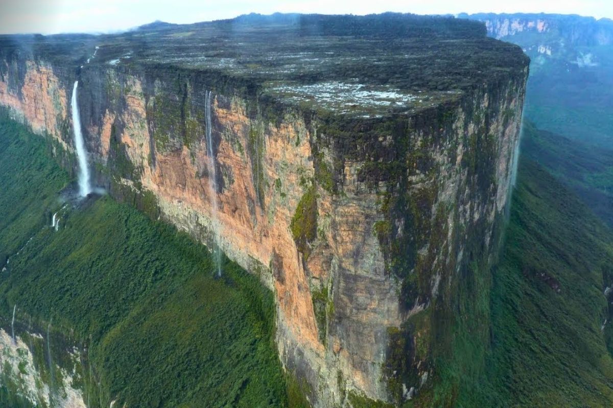
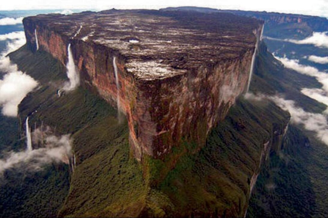
New Scientific and Cultural Dive into Mount Roraima Reveals Tepui with Walls of Up to 600 M, Preserved Fossils, Extreme Microclimates, and Still Unexplored Areas.
The Mount Roraima rises at the exact point where Brazil, Venezuela, and Guyana meet, in the heart of the Guiana Shield, as a natural fortress formed 1 to 2 billion years ago. At the summit, an isolated plateau between 2,700 and 2,800 meters above sea level gathers fossils, springs, and “mini-Amazons” shaped by constant humidity and cold at altitude, creating a unique ecological mosaic.
More than a postcard, the Mount Roraima is an open-air laboratory. Vertical walls of 400 to 600 meters, a summit of 30 to 35 km² and rains that can reach 2,000 to 3,000 mm per year sustain stable microclimates, endemic species, and cavities yet to be mapped. Between the reading of science and indigenous cosmology, the tepui continues guarding unanswered questions and answers that require method.
Where Myth Meets Geology
Mount Roraima is one of more than 100 to 120 tepuis of the Guiana Shield; less than a third has been explored with modern techniques, and fewer than ten have detailed 3D mapping.
-
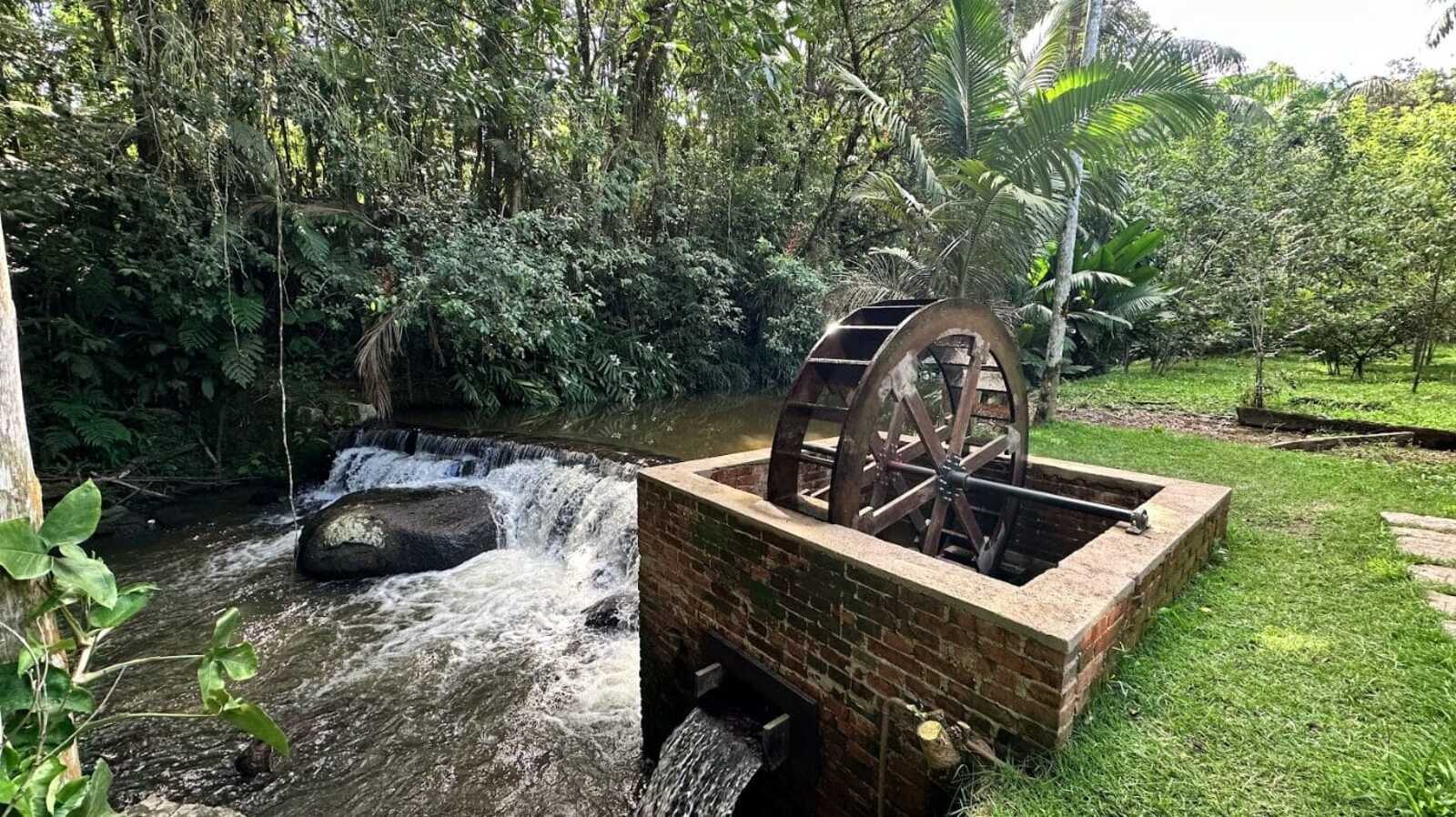
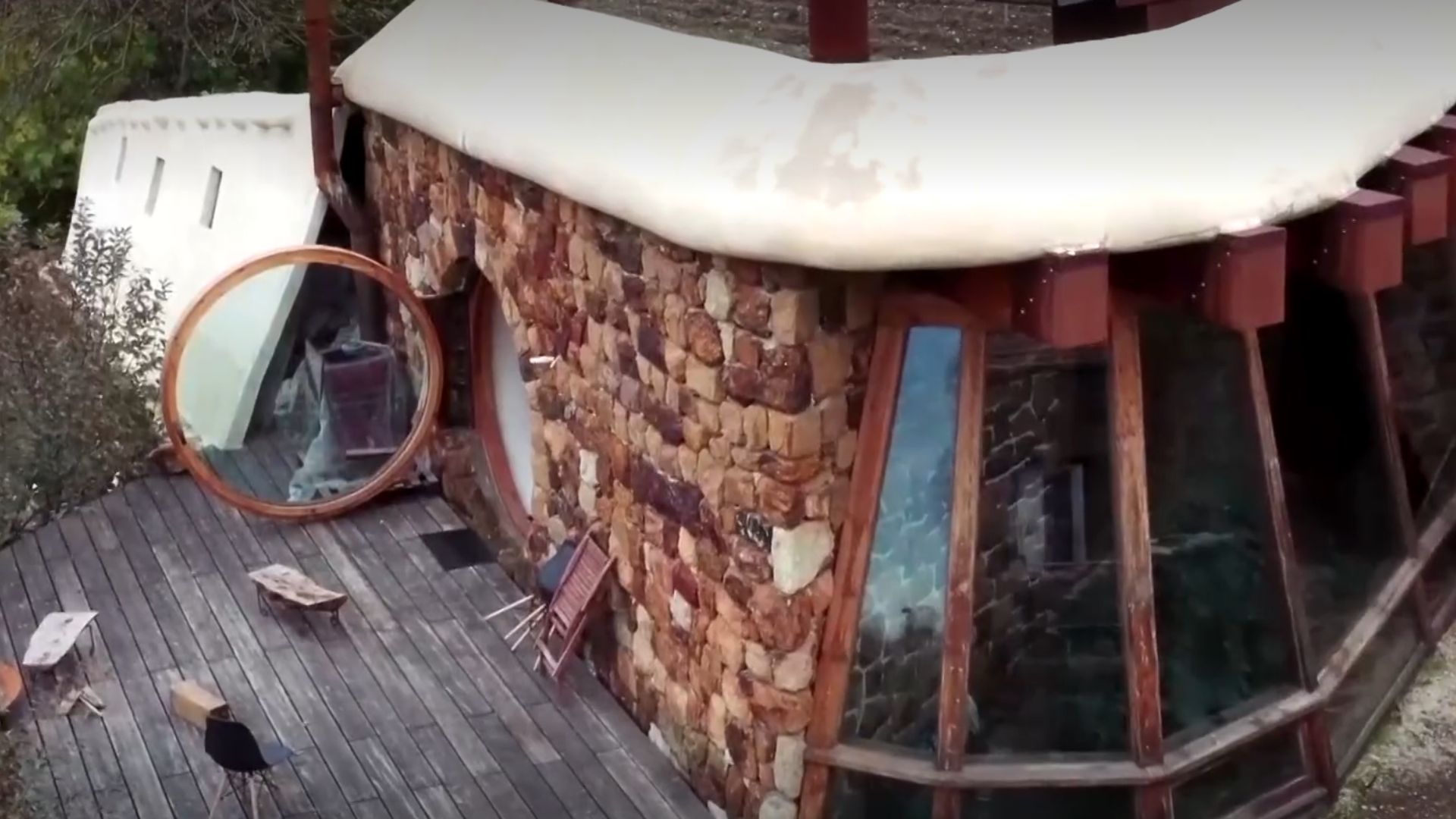
While restoring a historic mansion from 1910, a brick structure with an old turbine that generated energy from the Rio do Testo emerged, along with a hidden door and a rare floor concealed under layers of wax.
-
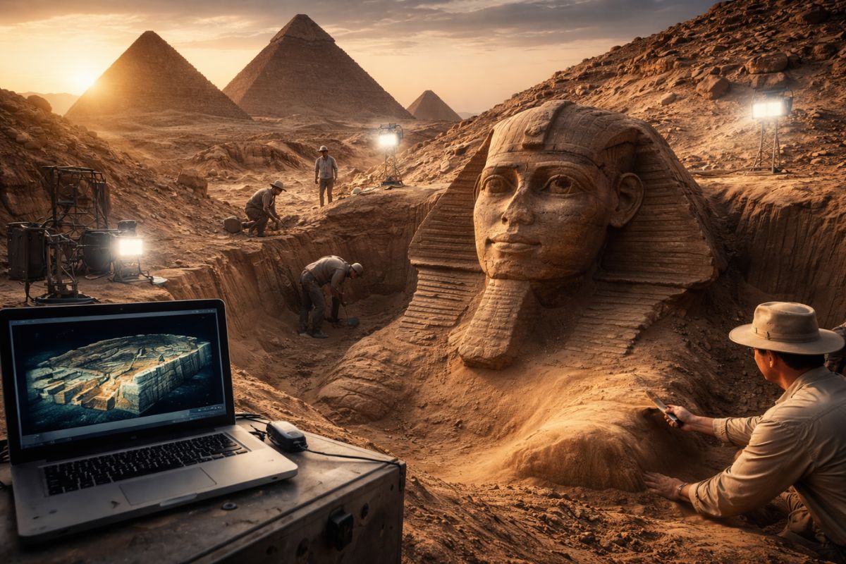
Italian researchers have detected what appears to be a second Sphinx buried under the sands of Egypt, and satellite scans reveal a gigantic underground megastructure hidden beneath the Giza Plateau for over 3,000 years.
-
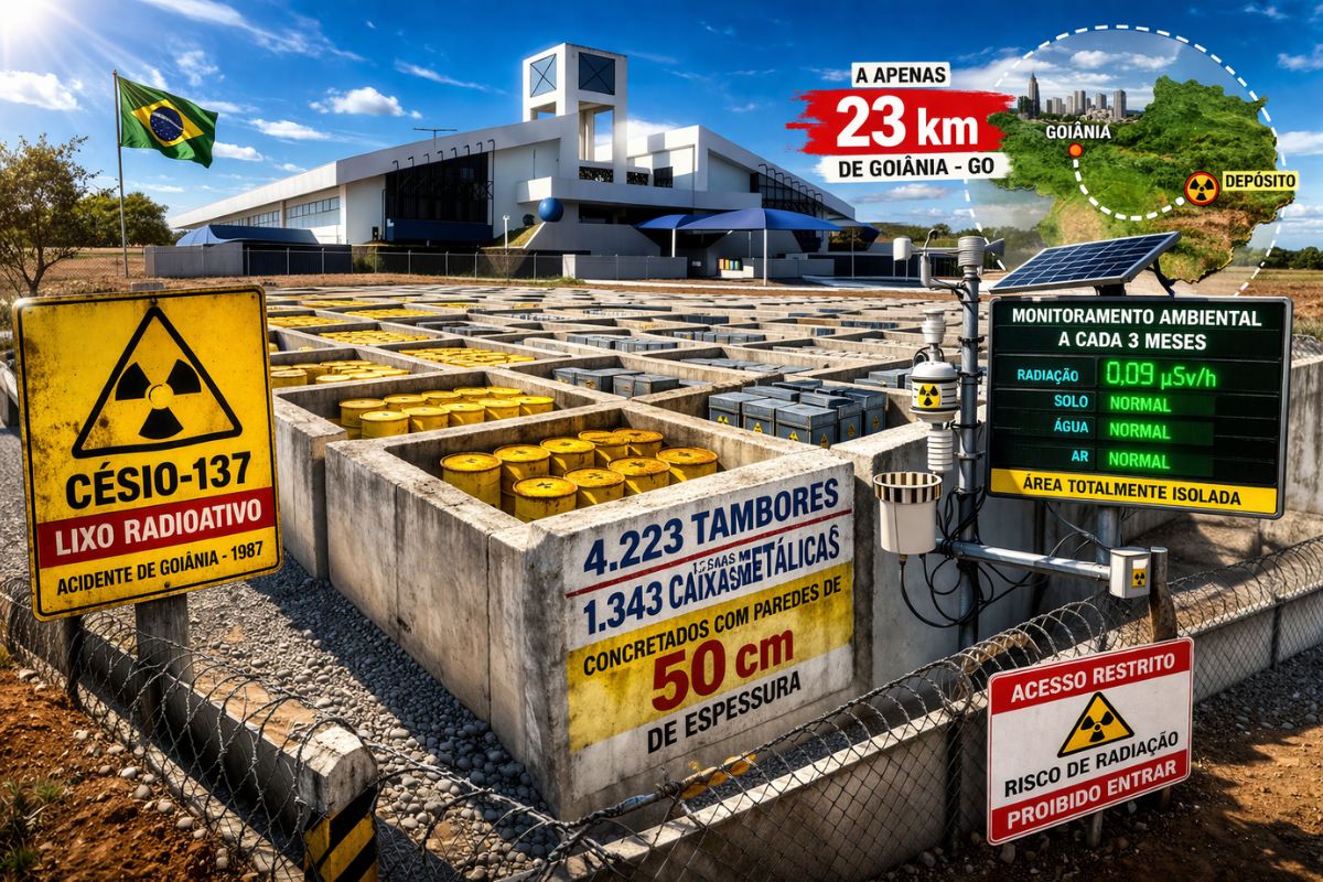
There are 4,223 drums and 1,343 metal boxes concreted with 50-centimeter walls that store the radioactive waste from Cesium-137 in the worst radiological accident in Brazil, just 23 kilometers from Goiânia, with environmental monitoring every three months.
-
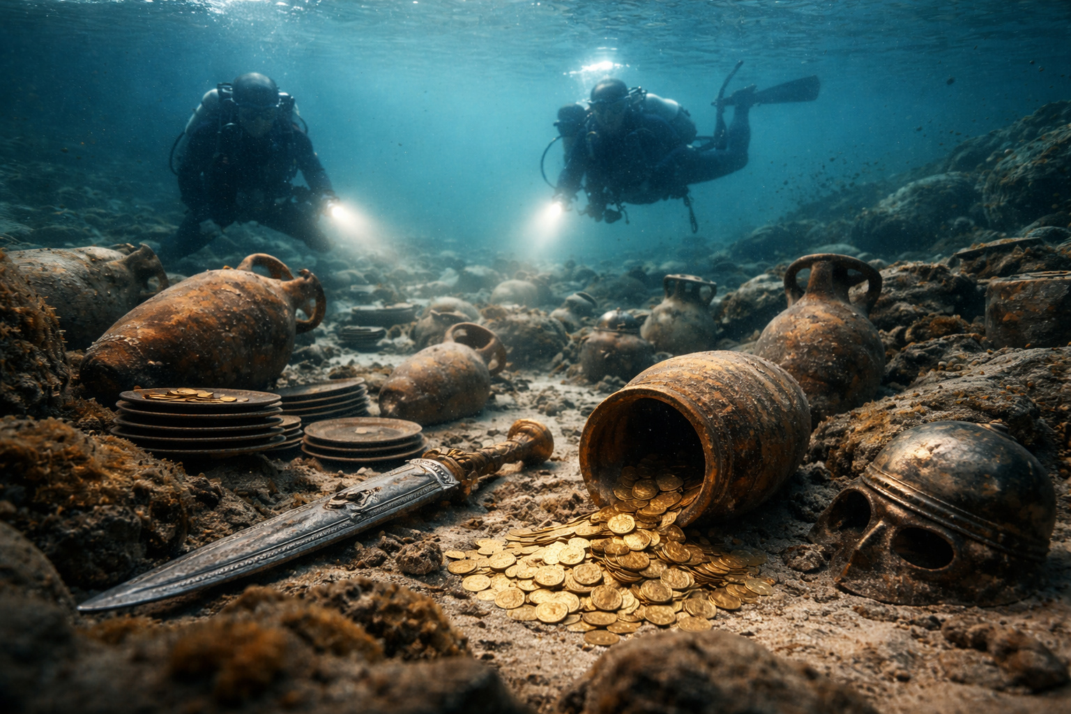
Giant Roman treasure found at the bottom of Lake Neuchâtel in Switzerland reveals an advanced trade system, circulation of goods, and armed escort in the Roman Empire about two thousand years ago.
For the Pemón, “tepui” is the “house of the gods”; for science, they are Proterozoic sandstone inselbergs, the resistant remnants of an eroded ancestral plateau over ages.
This dual reading does not exclude each other. Rare atmospheric phenomena, springs at the summit, deep fissures and the feeling of a “suspended island” feed sacred narratives while also raising verifiable scientific questions.
The scenery imposes humility: not everything can be explained in the lab and not everything is decided by myth.
The Engineering of Deep Time
The body of the tepui is compacted sandstone from times when oceans and atmosphere were very different from present.
Winds, water, and temperature variations sculpted the plateau and isolated “resistant towers”.
Volumetric estimates range from 10 to 15 km³; with average density of 2.3 to 2.5 t/m³, this represents 24 to 37 billion tons of rock. This colossal mass explains survival against time: only the hardest remains.
At the summit, acidic lakes, thick “carpet” mosses, and cold bogs create environments of extreme isolation.
Endemic species evolve “in island”, protected by vertical walls. For the observer, it is more than a mountain: it is a continental-scale ecological experiment.
Microclimates, Water, and the “Water Box” of the Continent
The humid slopes channel thousands of millimeters of rain per year, opening waterfalls that drop hundreds of meters.
At the summit, springs erupt from the rock and feed rivers that flow into three countries. It is not an exaggeration to call it a natural “water box”: the tepui captures moisture from clouds and redistributes it in a network.
Temperatures can drop to 5 °C under the sun at the top, while the access trail rises 40 to 50 km from the forest to the humid high-altitude fields. This sharp transition of climate and vegetation explains the great diversity and makes scientific and tourist logistics demanding.
Fossilization, Caves, and What We Still Don’t Know
There are preserved fossil records in the sandstone and deep cavities (sinkholes, grottos, fissures) with sections yet to be mapped; less than 20% of the summit has fine detailing.
Researchers apply LiDAR, drones, isotopic analysis, and biological inventories to date rocks, record shapes, and describe new species.
Limitations are real: clouds block sensors, authorizations restrict collections, and the terrain increases expedition costs.
Partial conclusion of researchers: Mount Roraima holds a living archive with layers that tell the story of deep Earth and isolated ecosystems that help us understand evolution, climate, and water in high-altitude tropics.
Tourism on the Rise, Pressure Too
Conservative estimates point to growth of 50% to 70% in tourism over 10 years. The flow generates income and visibility, but brings waste, trail erosion, and demand for new routes.
The rocky shield is ancient, not indestructible: a poorly planned route leaves scars. Experienced guides, group limitations, and waste management are critical measures to balance local economy and conservation.
Communities and myths also demand respect. Entering the tepui “asking for permission” is not just a rite: it is a guideline for coexistence between science, spirituality, and responsible public use.
Comparisons that Give Context (Without Taking Away Singularity)
Uluru (Australia) and African inselbergs help to gauge the exceptionality of Roraima. Roraima is older, taller, wetter, and more isolated.
The rare combination of age (1–2 billion years), altitude (≈2,800 m), extreme humidity, and impassable walls is not repeated with the same intensity. Thus emerge the “mini-Amazons” at the top: a mosaic that finds no direct analogy.
What is in common with other giants? Isolation, cultural reverence, and inspiration for myths. What sets them apart? Temporal and ecological scale, elevating Mount Roraima to the peak of a global geological pattern.
What Is Fact, What Is Probable, and What Is Legend
Fact: tepuis are Proterozoic sandstone formations; the summit of Roraima holds microclimates, water, and isolation that favor endemism.
Probable: there are dozens of species still to be described and vast caves yet to be mapped.
Legend: dimensional portals or artificial structures.
What exists are sinkholes, grottos, and fissures explainable by erosion and dissolution over millions of years.
In the face of extraordinary claims, the ruler is simple: what can be measured, mapped, dated, and replicated? This is how science advances without closing the door to the unknown.
The Mount Roraima condenses deep time, water, climate, and culture into a single landscape. It is an archive, laboratory, and sanctuary. Decisions about access, research, and tourism made today define what will remain for future generations: a high-altitude theme park or a “stone library” still readable.
And you? Have you been to Mount Roraima or do you intend to go? Should tourism have a daily limit on visitors? What mystery of the tepui would you like to see researched first: fossils, caves, or endemic species? Share in the comments how to balance science, culture, and visitation we want to hear from those who live and study the region in practice.


-

Uma pessoa reagiu a isso.