 Portuguese
  English
  Spanish
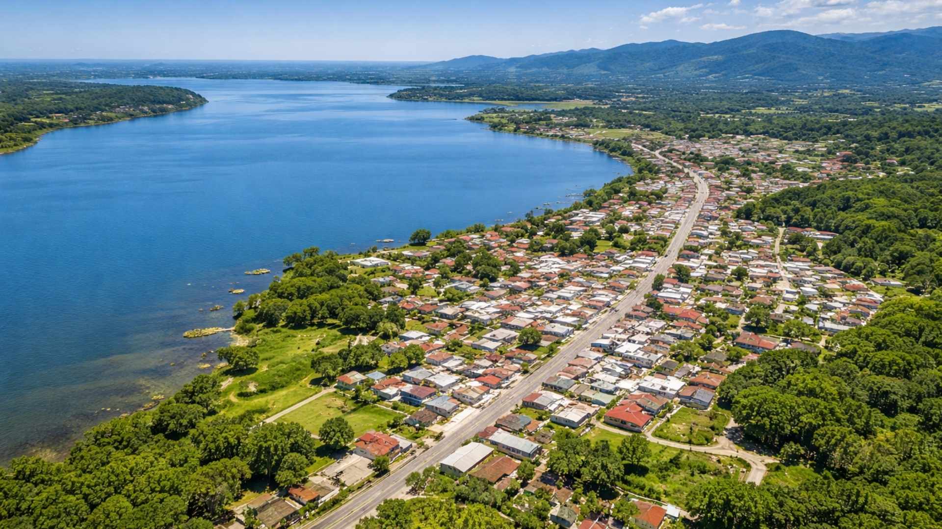
Young Municipality in Public Administration, but with Historical Origins Registered in the Nineteenth Century, Brings Official Data on Area and Population and Calls Attention to the Difference Between the Date of Installation and the Local Formation Documented.
Pescaria Brava, on the southern coast of Santa Catarina, is a recent municipality in public administration, but with local roots much older than the installation date suggests.
Officially established in 2013, the municipality appears in the IBGE databases with territorial area of 106.853 km² and population of 10,190 people in the 2022 Census, figures that help to gauge a young city in institutional terms, but with a history recorded since the nineteenth century.
The IBGE data also indicate demographic density of 95.36 inhabitants per km² in 2022 and estimated population of 10,615 people for 2025, showing the scale of the municipality and the size of the audience served by its own municipal services.
-
The Federal Revenue Service now automatically cross-references everything you declare with data from banks, credit cards, brokerage firms, and insurance companies, and any discrepancy between your income and your expenses triggers an alert in seconds.

-
Amid global tensions, Brazil blocks the United States’ proposal at the WTO and paves the way for a trade crisis and possible retaliations.

-
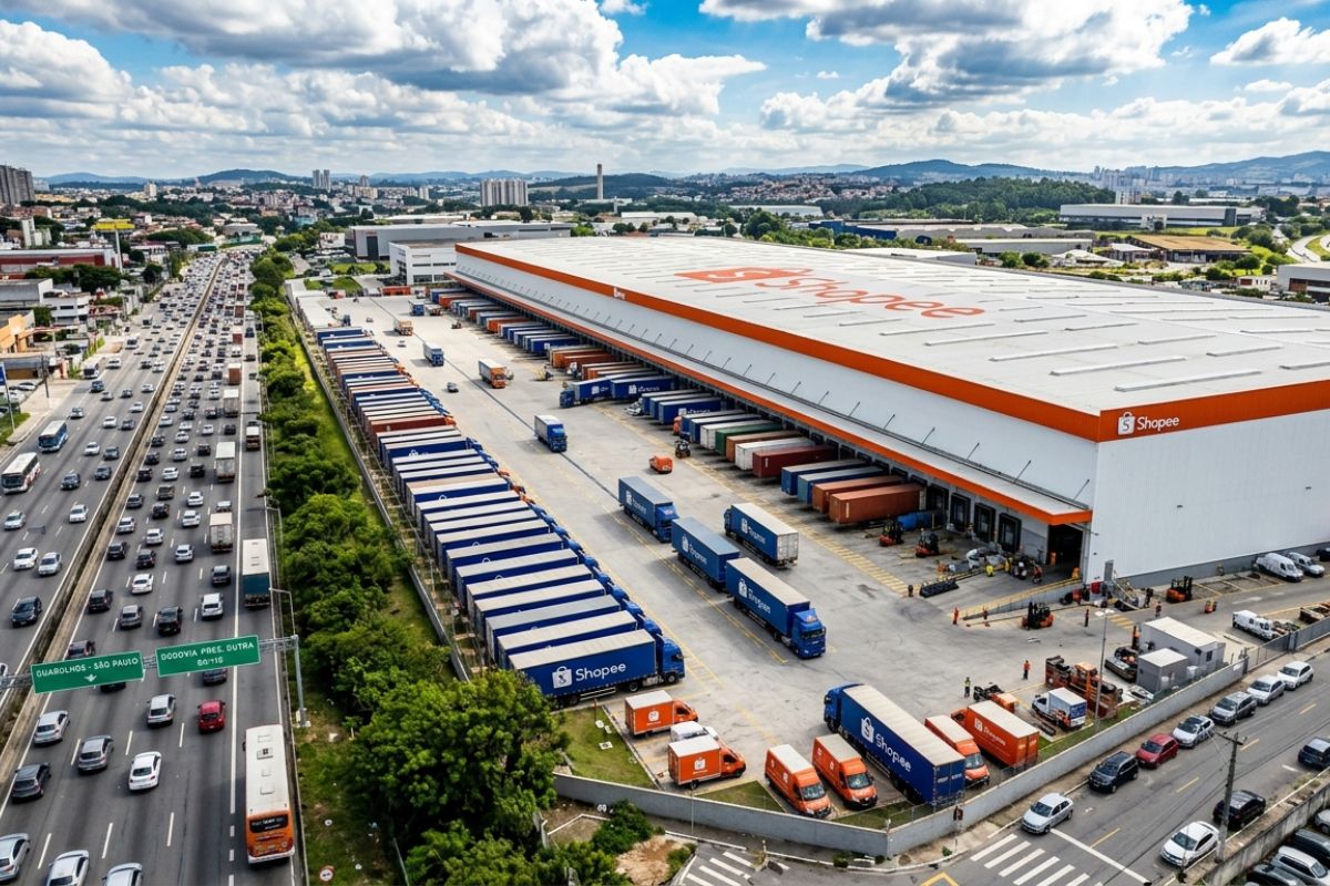
Shopee opens the largest logistics warehouse in Brazil in Guarulhos: 220,000 m² on Dutra, contract signed before construction, pays R$ 45/m² and accelerates deliveries at scale, putting pressure on Mercado Livre and Amazon.
-
After mistakenly transferring R$ 50,000 via Pix, a man will receive the amount back along with R$ 10,000 for moral damages from the recipient.


Legal Creation and Administrative Installation of the Municipality
The creation of Pescaria Brava as a municipality is formalized in state legislation.
Law No. 12,690, of October 25, 2003, sanctioned in Santa Catarina, established the creation of the Municipality of Pescaria Brava, dismembered from the Municipality of Laguna and constituted by the territorial area of the district of the same name, with headquarters in the urban center raised to the category of city.

Despite the existence of this law since 2003, the effective administrative installation is associated with 2013 in public records and institutional materials, which explains why the city is often described as a municipality “that became a municipality” in that year.
In institutional content published under the state program SC Mais Inovação, Pescaria Brava is presented as a municipality whose emancipation occurred in 2012, with official installation in 2013, indicating a gap between legal creation and administrative structuring that began to operate with its own local government.
This gap often raises questions among readers who follow lists of “newest municipalities,” because the milestones of legal creation and administrative installation may appear separated by years, depending on procedures and the implementation calendar.
Historical Origins of the District Founded in 1857
If the municipal structure is recent, the recorded local formation is much earlier.
The same material from SC Mais Inovação states that the district of Senhor Bom Jesus do Socorro da Pescaria Brava was created in 1857, associated with the construction of a homonymous chapel, and is presented as one of the oldest legally constituted districts in the country.
This historical data is central to understanding the contrast suggested by the title itself: a city with a “new” administrative stamp, but with documentation reference from the imperial Brazilian period.
Location and Geographical Characteristics on the Southern Coast of Santa Catarina

The geography of the municipality also appears as a point of identification in public descriptions.
SC Mais Inovação describes Pescaria Brava as located between the mountains and the lagoon complex on the southern coast of Santa Catarina, washed by the Lagoa de Imaruí, which connects the municipality to an environment of inland waters and transitional areas between relief and coastal plain.
This context helps to explain why, in institutional descriptions, the local economy is linked to activities that depend directly on the territory and its natural resources.
In the same text of the state program, the economy is described as mainly based on artisanal fishing and family agriculture, two activities cited as part of the community’s connection to the local environment.
Territorial Limits Defined in State Law
The state law that created the municipality also details limits and geographical references, allowing for a more precise location of Pescaria Brava on the regional map.
The legal text describes borders with the Municipality of Imaruí, referencing watercourses and Lagoa de Imaruí, and establishes segments of boundary with Laguna, including mention of the Cabeçudas bridge on the BR-101 highway, as well as references to hills and watersheds used as delimitation markers.
The same law also records limits with Capivari de Baixo and Gravatal, in segments described from streams, springs, and watersheds, a common way of defining municipal limits in territorial legislation.
In practice, this set of delimitations helps to explain why the municipality is associated with a stretch of the southern coast where highways, lagoons, and mountainous areas appear as recurring elements of spatial orientation.

Municipal Statistics After Emancipation
With the municipal installation, official indicators began to consolidate Pescaria Brava separately from the statistics of the municipality of origin, which impacts comparisons and readings on population, territory, and administration.
In the “Cities and States” panel of the IBGE, in addition to area and population, information such as gross revenues and expenses and the municipality’s per capita GDP also appear, data that are part of the standardized municipal portrait in the country and allow comparisons of Pescaria Brava with other Santa Catarina cities on official bases.
Within these records, the gentilic “bravense” also appears as the formal identification of the municipality’s resident, reinforcing the administrative and statistical standardization after the installation.
The coexistence of a district origin from 1857 with the municipal installation in 2013 often draws attention because it brings together two different times in the same place: the historical time of local formation and the recent time of administrative autonomy.
Had you heard of another Brazilian municipality that is institutionally new but carries a documented historical origin for over a century?


Seja o primeiro a reagir!