 Portuguese
  English
  Spanish
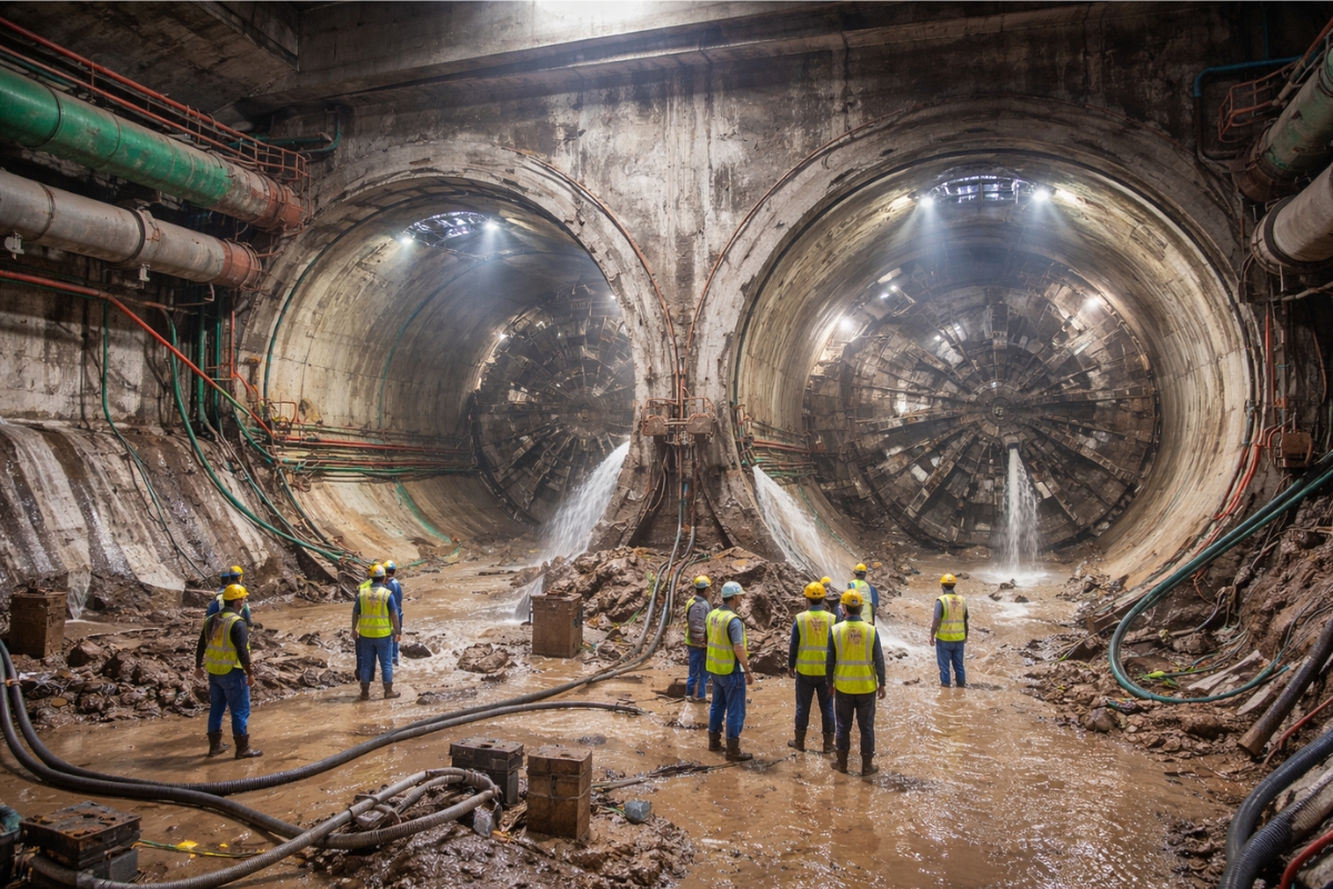
The Crossing Under the Hooghly Created India’s First Transport Tunnel Under a River and Required Extreme Control of Infiltrations and Saturated Soil
The East West Line of the Kolkata Metro gained its most sensitive section by passing underneath the Hooghly River. The heart of the project lies in two twin tunnels that connect Kolkata and Howrah.
The crossing occurs in an alluvial terrain with sands, silts, and saturated clays, a type of soil that can react to small changes in pressure. This raised the level of care required for excavation, sealing, and monitoring in densely populated surface areas.
The entire corridor has a total length of 16.6 km, with elevated and underground sections. Within this set, the passage under the river has become a benchmark for being the first of its kind in the country.
-
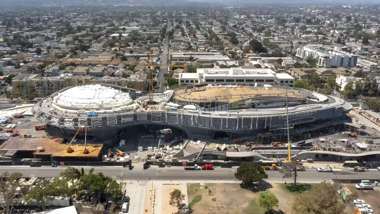
Created by George Lucas with over $1 billion, a futuristic museum in the shape of a spaceship with 1,500 curved panels is about to open in Los Angeles and will house one of the largest private collections of narrative art in the world.
-
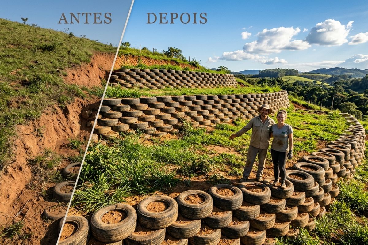
Couple shows how they built a retaining wall on their property using 400 old tires: sloped land turned into plateaus, tires are aligned, filled, and compacted with layers of soil, with grass helping in support and at almost zero cost.
-
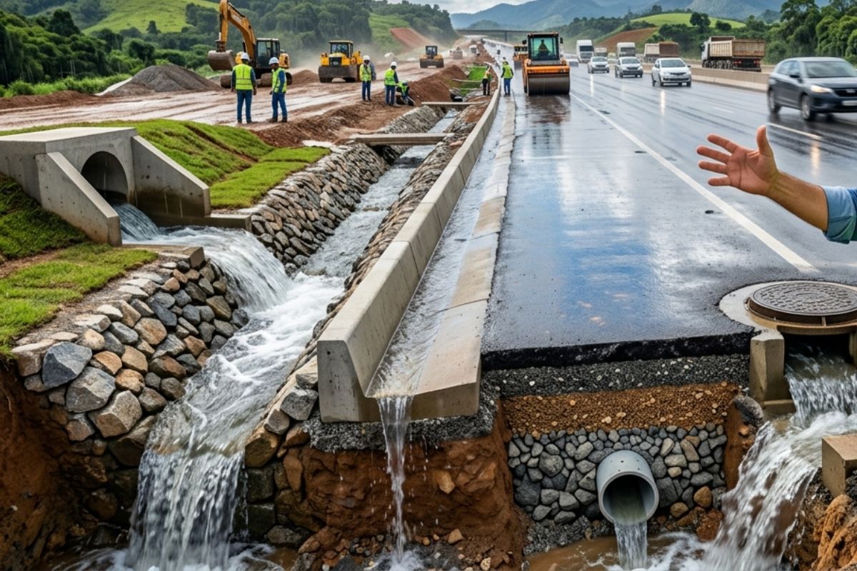
Engineer explains drainage during the rainy season: the difference between surface water and deep water, ditches, gutters, and water outlets on the road, as well as drains and drainage mattresses, to prevent erosion, aquaplaning, and flooding at the construction site today.
-
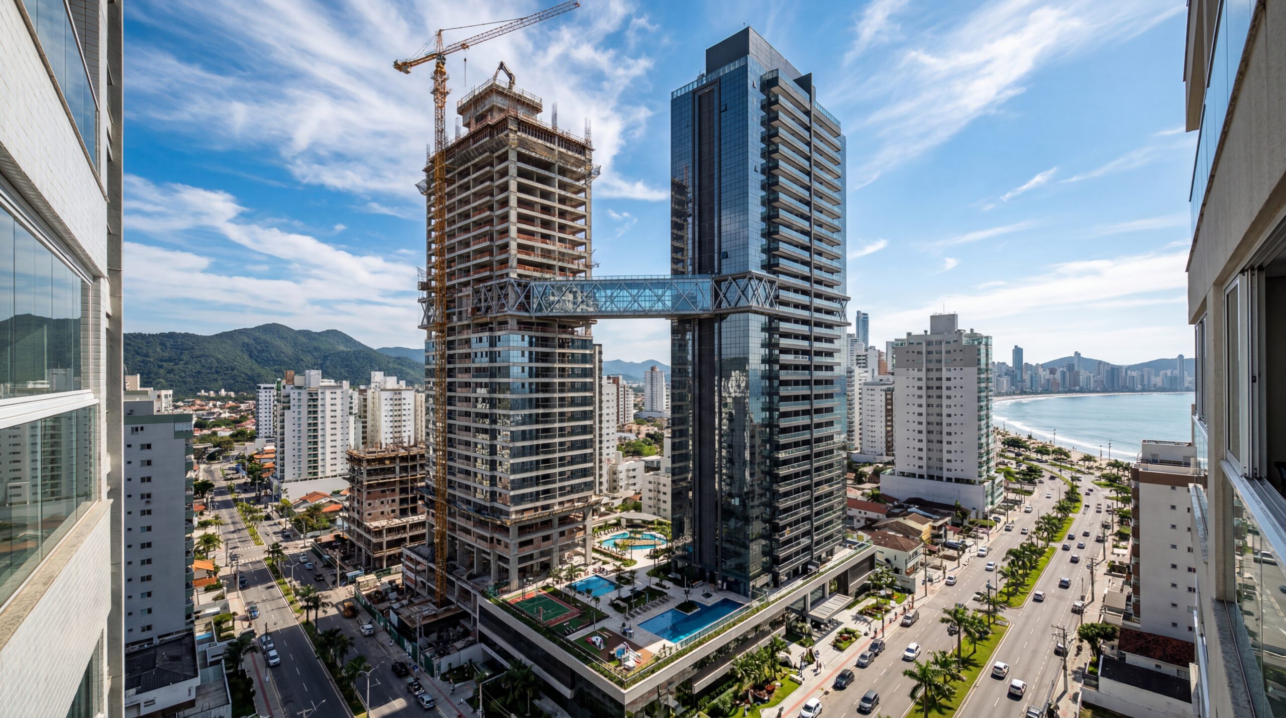
With 55 floors, 177 meters in height, a 15-meter walkway between the twin towers, ventilated facade, and 6,300 m² of leisure space, Ápice Towers already has one tower completed and another nearly at the top.

The Most Delicate Section of the East West Line Is Exactly Under the Hooghly River
The critical point of the project is the crossing of 520 meters beneath the Hooghly, made with twin tunnels. The structure connects two urban sides that rely on intense daily commuting.
The excavation was positioned about 13 m below the riverbed. This depth aims to reduce risks related to erosion of the bottom but keeps the tunnel within very deformable layers.
Therefore, each step required strict control to prevent soil displacement and any impact on the neighborhoods above.
The Line Is 16.6 Km Long and Concentrates About 10 to 11 Km in Underground Sections

The East West corridor totals 16.6 km, with elevated parts and tunnel sections. The underground extension reaches 10 to 11 km, crossing dense areas with old infrastructure.
This type of layout increases the challenge, as the work takes place below narrow streets, old buildings, and sensitive urban networks.
The result is a project that must maintain continuous stability, with no room for abrupt fluctuations during excavation.
The Soil of Kolkata Mixes Sand, Silt, Clay, and Peat with Water Everywhere
The local geology is dominated by alluvial deposits with sands, silts, clays, and peats, along with layers of firmer clay interspersed. This creates rapid changes in ground behavior along the route.
Under the river, it was possible to take advantage of a relatively firm clay layer. Meanwhile, on the urban margins, mixtures of sand and saturated clay emerged, with a higher risk of infiltration.
In such a scenario, any loss of control can lead to settlement, cracks, and surface damage.
Earth Pressure TBMs Had to Maintain the Balance of “Living Soil”

The excavation was carried out with earth pressure TBMs, adjusted for soft ground. Their main function is to support the excavation front and balance the pressure of the soil and water.
The advancement required precision, as small variations in internal pressure or excavation speed can cause movements in the terrain.
This behavior gave rise to the idea of “living soil,” as the environment reacts sensitively to minimal changes.
Sealing with Hydrophilic Joints and Project Lifespan of 120 Years
The tunnels were constructed with precast concrete rings and hydrophilic joints, designed to expand and seal when in contact with water. The assembly has an estimated project lifespan of 120 years.
This solution helps contain infiltrations and strengthens the structural safety of the stretch under the river.
Even so, water control remains one of the most critical points, especially in saturated terrain.
Ground Freezing Helped to Excavate Critical Areas Near the River
In more sensitive zones, such as accesses and shafts near the Hooghly, localized ground freezing and soil improvement techniques were used. The technique temporarily hardens the saturated sands.
This reduces the risk of collapse during excavation and prevents the site from becoming a pathway for water ingress.
The method works as a temporary reinforcement to traverse points where the ground is more unstable.
Mahakaran and Sealdah Came onto the Radar with Millimetric Monitoring of Settlements
When the TBM approached historical and dense areas, such as Mahakaran and Sealdah, monitoring networks were installed with hundreds of measurement points.
The goal was to monitor settlements and movements in buildings and urban services, detecting any changes right at the beginning.
Concerns grew as incidents of subsidence and damage to housing in another phase of the project showed how localized failures can affect entire regions.
The crossing under the Hooghly established Kolkata as the first Indian city with a transport tunnel under a major river, highlighting the 520 meters in twin tunnels.
In addition to the urban impact, the project leaves a clear message: in saturated alluvial soil, safety depends on stable pressure, efficient sealing, and constant monitoring to prevent infiltrations and settlements.


-

-

-

-

-

12 pessoas reagiram a isso.