 Portuguese
  English
  Spanish
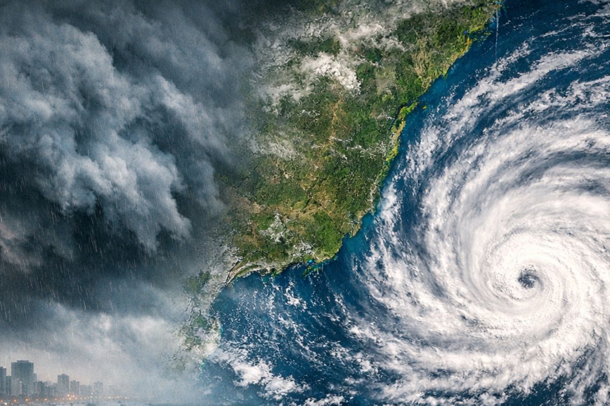


The Fourth Cyclone Of 2026 Starts To Configure On Monday, February 2nd, With Low Pressure In The South And A Moisture Corridor Activating Storms. The Forecast Indicates Accumulations That Could Reach 250 Mm Until Wednesday, 4, With Yellow And Orange Alerts From Inmet In States Of The Country.
The cyclone came onto the radar after Brazil has had, since Friday (30), a sequence of more humid and unstable days, with a forecast of storms and high rainfall volumes until at least Wednesday (4). The possibility of a new low-pressure system evolving near the coast changes the level of attention for the coming days.
The scenario described by meteorologists increases the risk of typical disruptions from persistent rain: flooding, flash floods, inundations, hail, and intense gusts of wind. It’s not just “raining more”: it’s raining for longer and in a more organized manner, with active instability for several days.
Why This Cyclone Gained Strength On The Radar Now
What put the cyclone at the center of the forecast was the combination of an already unstable period with the entry of a new atmospheric trigger. Since Friday (30), the indicated trend is for high humidity and storms, with accumulations that may extend until Wednesday (4). When the atmosphere remains “charged” for days, small adjustments in the system can amplify the impacts.
-
How the terraforming of Mars can transform the planet: artificial aerosols can increase the temperature by up to 35°C in 15 years, creating conditions for liquid water.

-
Scientists drilled nearly 8,000 meters into the ocean floor above the fault that caused the 2011 tsunami in Japan and discovered that a layer of clay 130 million years old was responsible for making the wave much worse than any model had predicted.

-
Thousands of years after causing the largest eruption of the Holocene, one of the world’s largest supervolcanoes is rebuilding itself beneath the sea south of Japan, receiving new magma and alarming scientists with its transformation.

-
China has activated a magnet 700,000 times more powerful than the Earth’s magnetic field that operates for over 200 consecutive hours while consuming little energy, and now the world wants to know what Beijing plans to do with this technology in 2026.

In addition, there is a relevant detail: rain tends to occur in a more “organized” way because a low-pressure system could strengthen and evolve into the fourth cyclone of 2026 near the Brazilian coast. This helps to understand why the alert is not linked only to isolated showers, but to a sequence that can keep the weather unstable and rainy.
What Feeds Instability And Sustains Storms For Several Days
According to Meteored, a corridor of moisture coming from South America increases water vapor levels in the atmosphere. In practice, this means available “fuel”: with more moisture, the atmosphere sustains heavy clouds for longer and favors persistent storms. It’s this continuous transport of moisture that prevents instability from “turning off” quickly.
The atmospheric circulation reinforces the process by keeping the moisture transport active for several days. And, when a new low-pressure system enters this mechanism, the effect can be reinforcing: the pattern becomes more organized and the chance of high volumes in a short interval increases in specific areas, with a greater risk of disruptions.
Where Accumulation Can Be Most Extreme And How This Changes Local Risk
By Wednesday night (4), the regions mentioned with the highest risk of significant accumulations include Mato Grosso do Sul, São Paulo, Goiás, Minas Gerais, Paraná, and Santa Catarina.
The most critical point appears for Mato Grosso do Sul, where volumes could exceed 250 mm, with a significant part of the expected rain falling in a short interval. When a lot of rain concentrates in a short time, the impact on the ground is usually immediate.
In São Paulo, accumulations may vary between 150 mm and 190 mm, with greater attention to the north of the state and areas near the western border. In Minas Gerais, some points may also approach 150 mm, worsening the situation in places where the soil is already saturated. Saturated soil does not “absorb” the same way: water runs off more, and the risk of flooding increases.
South In The Center Of The Mechanism: Low Pressure, Coast And The “Anchor” That Holds The Moisture
The fourth cyclone of 2026 may start to configure as early as this Monday (2), when a new area of low pressure is likely to intensify in the south of the country and evolve into another cyclone. Here comes an image used in meteorological explanation: this type of system works as a kind of “anchor” in the atmosphere, helping to channel moisture from the Amazon in the form of an atmospheric river. When the “anchor” firms, rain stops being episodic and can become persistent.
In Paraná and Santa Catarina, especially in the eastern strip and metropolitan regions, accumulations may exceed 100 mm, in addition to the possibility of more severe storm episodes. This detail is important because, even with smaller volumes than those in the Midwest in some scenarios, dense urban areas with pressured drainage tend to feel the effects quickly.
Inmet Alerts: What Yellow And Orange Mean In The Middle Of The Week
Given the potential for intense rains, Inmet issued yellow and orange alerts for several states, reinforcing the need for heightened attention. These alert levels come precisely when the risk goes from being “only” discomfort to involving concrete effects on daily life, such as interruptions in movement, flooding points, and occurrence of strong winds and hail.
The decisive detail is that the alerts relate to persistence: it’s not just a quick peak, but a period of active instability for several days. When the forecast talks about a sequence, attention needs to be continuous, because the risk changes from neighborhood to neighborhood and hour to hour as volume accumulates.
Why The Forecast Can Still Change And What To Observe Until Monday
Meteorological models may still vary regarding the exact day and position of the formation, making constant monitoring essential in the coming days. This happens because small differences in the track and intensity of the low-pressure system can shift the bands of higher accumulation and change where the heaviest rain concentrates.
Even with this possible variation, the main signals are already appearing: a corridor of moisture raising water vapor, sustained instability, and the chance of evolution into a cyclone near the coast. What changes is not the existence of risk, but the more precise distribution of the “where” and “how much” and that is precisely what can separate sporadic disruptions from a broader scenario.
The fourth cyclone of 2026 enters the radar because it may form starting Monday (2) near the coast and reinforce a sequence of instability that has been ongoing since Friday (30), with potential for storms and high rainfall volumes until at least Wednesday (4).
With a forecast of up to 250 mm in higher-risk areas and yellow and orange alerts from Inmet, the central point is persistence: organized rain over days tends to increase the impact on the ground, in the city, and on the roads.
In your region, what usually causes the most trouble when the rain comes “in sequence” – rapid flooding, power outages, wind, or hail? And have you ever experienced a situation where the soaked ground from one day became a serious problem the next?


Here in Rio de janeiro we have been experiencing so much rain too (like soo much,the next 15+ days has a 30%+ chance for rain atleast one or more time/s)