 Portuguese
  English
  Spanish
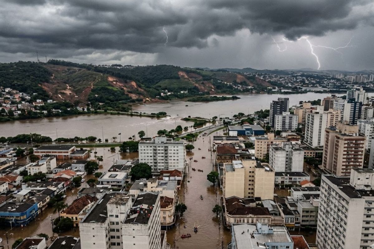


Understand Why Rio Grande do Sul Flooded in 2024 According to Researchers from Cemaden and Unesp, Who Link Exceptional Rain, Lago Guaíba at Record Level, Deforestation, Unplanned Urban Expansion, and Loss of Natural Areas to the Greatest Environmental Disaster in the History of Rio Grande do Sul, and Millions of People Affected in 2024.
In May 2024, Rio Grande do Sul experienced the largest environmental tragedy in its recent history: extreme rains, successive floods, and Lago Guaíba at a record level brutally exposed why Rio Grande do Sul flooded in 2024 and how entire populations were put at risk. In total, about 2.3 million people in 471 municipalities were affected, 600 thousand had to leave their homes, and 173 residents died, in a scenario that surpassed the historical flood of 1941 in Porto Alegre in scale.
One year later, a study by researchers from Cemaden and the Institute of Science and Technology of Unesp in São José dos Campos detailed the natural and anthropogenic causes that converged for the disaster. The work combines hydrodynamic modeling, rain data, historical series of Guaíba levels, and land use maps to show that outlier rains found a more deforested territory, more paved, and with a high concentration of people in areas highly susceptible to flooding, responding in technical terms and with numbers why Rio Grande do Sul flooded in 2024.
How Science Responded Why Rio Grande do Sul Flooded in 2024

The study, signed by 17 researchers, starts with a central question: what physical and anthropogenic factors explain why Rio Grande do Sul flooded in 2024 at that scale.
-
In a flooded well, archaeologists found a 1,700-year-old Roman egg that still contains clear and yolk intact inside the very thin shell.

-
Something is happening around the Earth: Inside the huge explosion of fireballs in 2026

-
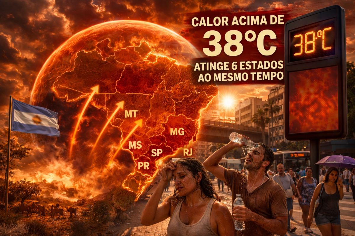
A hot air bubble coming from Argentina expands over Brazil, causing thermometers to exceed 38 degrees with a thermal sensation of 40 degrees in late March, affecting 6 states at once.
-
The radish leaf that almost everyone throws away has more polyphenols, flavonoids, and fiber than the consumed root, and a 2025 study showed that the leaf contains compounds that protect the intestine, combat inflammation, and may inhibit the growth of cancer cells.


To answer this, the scientists crossed hydrological, climatic, and urban data from the metropolitan region of Porto Alegre and basins such as Jacuí, Taquari, and Caí, which acted together during the event.
The team used a hydrodynamic model to simulate how water behaves when the basins discharge large volumes into the Guaíba system, considering topography, land use, and impermeable areas.
The result is striking: almost 18 percent of the metropolitan region of Porto Alegre is classified as being at extreme flooding risk, including densely populated neighborhoods.
According to the group coordinator at Unesp, Enner Alcântara, the data highlight the combination of extreme rain and constructed vulnerability.
It was not just an isolated climatic episode, but the simultaneous operation of overloaded basins, unprotected slopes, reduced wetland areas, and cities that are much more paved than a few decades ago.
From 1941 to 2024: When Guaíba Surpassed All Limits

Comparison with the past helps to gauge the leap in gravity. In 1941, the historical flood in Porto Alegre inundated about 15 thousand homes, displaced 70 thousand people, and kept a third of commercial and industrial establishments flooded for about 40 days, in a city that had 272 thousand inhabitants.
In 2024, the effect was broader and more intense.
The water level of Lago Guaíba reached 5.35 meters at Cais Mauá, 59 centimeters above the level recorded in 1941.
The crucial difference lies in the geographical scale: while the old flood was mainly concentrated in the Jacuí basin, in 2024 it simultaneously involved Jacuí, Taquari, and Caí, expanding the affected area and complicating any coordinated response.
With Porto Alegre today home to 1.3 million inhabitants, and a much denser and paved metropolitan region, the same type of hydrological event produces much more destructive impacts.
The study shows that, over decades, successive governments relied on the perception that flood defense works were sufficient, without incorporating the new scenario of more frequent and intense extreme events into planning.
Extreme Rains, Climate Change, and the Collapse of Natural Absorption

The rainfall data analyzed by the researchers confirm that the event of 2024 was extraordinary in intensity and persistence.
In April 2024, the accumulated precipitation in the metropolitan region of Porto Alegre ranged between 50 millimeters and 250 millimeters, with anomalies of up to 200 millimeters above the historical average considered between 2001 and 2023.
In May 2024, the situation worsened: the region received between 200 millimeters and 400 millimeters of rain, with distortions in relation to the average reaching 450 millimeters.
At the northern edge of Greater Porto Alegre, there were points with more than 500 millimeters of precipitation in a single month. For a territory already under pressure, these volumes are enough to break any safety margins.
The climatologist José Marengo, also a co-author of the study, emphasizes that global climate change is increasing the probability of episodes like this in the South and in other regions of the country. According to him, the storm, alone, is not the tragedy.
The disaster occurs when intense rains hit highly vulnerable populations, in poorly planned areas, with insufficient drainage and little soil absorption capacity.
Deforestation, Urban Expansion, and Excess Asphalt on the Water Route
The question why Rio Grande do Sul flooded in 2024 cannot be answered only with rain maps. The study shows that, between 1985 and 2020, the metropolitan region of Porto Alegre underwent a continuous process of loss of natural vegetation and expansion of impermeable urban areas.
In terms of forests, all evaluated cities suffered losses, with variations reaching up to 85 square kilometers in certain periods.
The municipalities of Arroio dos Ratos, Dourado do Sul, Montenegro, São Jerônimo, and Triunfo, west of the capital, are among those that lost the most forest cover.
In non-forest natural formations, such as wetlands, fields, and restingas, the losses are even more significant, with variations of up to 121 square kilometers and accumulated drops exceeding 670 square kilometers in some intervals, especially between 2000 and 2005 and 2015 and 2020.
Cities like Glorinha, Gravataí, Guaíba, Santo Antônio da Patrulha, and Viamão show significant reductions in these environments that function as natural water buffering zones.
In the opposite direction, areas paved by urban expansion grew at an accelerated pace. Municipalities like Alvorada, Canoas, Gravataí, Novo Hamburgo, São Leopoldo, and Viamão recorded consistent increases in surfaces covered by asphalt and concrete, with Porto Alegre leading the list.
In total, more than 14 square kilometers of new impermeable areas emerged in just the first 15 years of the analyzed period, hindering rainwater drainage.
The result is a territory that has lost infiltration capacity, reduced wetlands and floodable areas, and concentrated more people exactly in the ranges of low altitude and high susceptibility to flooding.
When the extreme rains of April and May 2024 arrived, there was no natural space to hold the water and there were rigid surfaces that accelerated runoff to already saturated rivers.
What Needs to Change After the Biggest Environmental Tragedy in the State
Based on the hydrodynamic model and land use series, the authors of the study argue that the response cannot be limited to emergency works after the disaster.
It is necessary to reassess urban planning, update risk maps, recover strategic natural vegetation, and modernize drainage infrastructures that today operate at the limit.
Among the highlighted measures are:
restoration of wetland and floodplain areas, which act as natural sponges in extreme events
review of occupations in high-risk zones, with policies for gradual removal and dignified resettlement
integration of climatic, hydrological, and social data into early warning systems that are understandable to the population
urban expansion planning that limits continuous impermeabilization and preserves natural drainage corridors
Scientists warn that the experience in Rio Grande do Sul serves as a direct warning for cities located in regions such as Serra do Mar, Serra da Mantiqueira, and other sensitive relief corridors, where the combination of unplanned urbanization with extreme climatic events is likely to repeat in the coming decades.
In a scenario where climate models already indicate more intense and frequent rains in various areas of the country, the answer to the question why Rio Grande do Sul flooded in 2024 cannot be restricted to academic reports.
It must guide political decisions, master plans, public works, and environmental oversight, or risk turning extreme events into a routine of avoidable tragedies.
In your opinion, what should be the number one priority for governments to prevent a new flood like the one in 2024 in Rio Grande do Sul: recover natural areas, rethink occupations in risk zones, or modernize all urban drainage infrastructure?


A ocupação desordenada nas várzea de rios e corpos d’água, o assoreamento desses rios e das bacias de depósitos hídricos, o desastre só não foi maior devido a dragagem executada no canal de Rio Grande ao qual permitiu vazante durante todo o período de enchente…as plantações e desmatamentos nas encostas acelerando o processo de erosão e dando consequência no assoreamento permitindo a ocupação expressiva das várzea muitas vezes ocupadas pela urbanização.