 Portuguese
  English
  Spanish
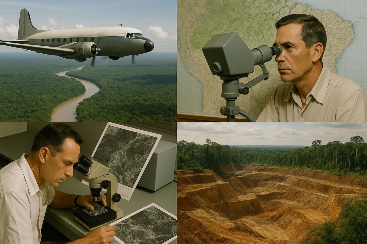
In The 1970s And 1980s, The RADAMBRASIL Project Used Pioneering Radar Technology To Uncover The Amazon. Know The Discoveries, The Impacts And The Legacy Of This Ambitious And Controversial Aerial Mapping.
In The Mid-20th Century, The Amazon Was A Vast Territory Of Mysteries And Untapped Potential For Brazil. To Change This Reality, The RADAMBRASIL Project Emerged, A Monumental Initiative That, Using Airborne Radar Technology, Conducted An Unprecedented Mapping Of The Region. This Effort Revealed Its Immense Mineral Wealth, The Diversity Of Its Ecosystems, And Also Its Deep Fragilities.
Conceived In A Context Of Developmentalism And Geopolitical Concerns During The Military Regime, The RADAMBRASIL Project Generated A Volume Of Information That Transformed Knowledge About The Country. However, It Also Paved The Way For Intense Debates About Its Socio-Environmental Impacts, A Legacy That Endures To This Day.
RADAMBRASIL Project: Uncovering A Then Unknown Continent
Until The Early 1970s, The Amazon Was An Immense Unknown. Its Vast Extent, The Dense Forest, And The Constant Cloud Cover Made Exploration And Systematic Scientific Knowledge Difficult. This Information Vacuum Was A Barrier To National Development Plans.
-
The coldest seawater ever recorded in Earth’s history was hidden under extreme ice 717 million years ago and reached an impressive -15°C.

-
China has launched the world’s first floating artificial island, a scientific structure designed to face open seas, test equipment weighing hundreds of tons, and reach depths of 10,000 meters.

-
China accelerates global science and may surpass the United States in 2 years with increased public investment, continuous growth, and direct impact on the global technological competition.

-
Scientific studies indicate that drought may be strengthening a much greater silent threat: more resistant superbugs.

The RADAMBRASIL Project, Formally Initiated In October 1970 With Resources From The National Integration Plan (PIN), Emerged In This Context. The Motivations Were Geopolitical And Developmental, Aligned With The Military Regime’s Strategy To Integrate The Territory, Ensure National Security, And Exploit The Amazon’s Natural Resources. The Idea Was “Integrate To Not Deliver”.
The Cutting-Edge Technology And Operational Scale Of The RADAMBRASIL Project

The Key To The RADAMBRASIL Project Was The Adoption Of Side-Looking Airborne Radar (SLAR). This Pioneering Technology Allowed Imaging Of The Surface Regardless Of Solar Light Or Cloud Cover, A Decisive Advantage In The Amazon. The Sud Aviation Caravelle Aircraft, Equipped With The GEMS-1000 System, Flew At About 11,000 Meters Altitude, Mapping Vast Strips Of The Territory With Remarkable Resolution For The Time.
The Scale Was Monumental, Resulting In Hundreds Of Thematic Maps. The Success Also Depended On Multidisciplinary Teams On The Ground And The Crucial Logistical Support From The Brazilian Air Force (FAB), Which Used Bandeirante Aircraft And Bell Helicopters For Transport And Insertion Of Personnel In Remote Areas.
The Main And Impactful Discoveries
One Of The Most Transformative Consequences Of The RADAMBRASIL Project Was The Revelation Of A Vast Mineral Potential. The Carajás Mineral Province (PA), With Its Gigantic Iron, Manganese, Copper, And Gold Deposits, Was One Of The Major Highlights. Other Discoveries Included Tin In Pitinga (AM) And Rondônia, And Oil In Urucu (AM).
In Addition To Minerals, The Project Conducted A Systematic Mapping Of Vegetation Cover, Soil Types, And Land Use, Providing The First Integrated View Of The Amazon Landscape. The Hydrography Of The Basin Was Also Detailed Mapped, Essential Information For Navigation And Infrastructure Planning.
RADAMBRASIL Project Exposed Both Wealth And Vulnerabilities
The Information From The RADAMBRASIL Project Was Actively Used To Guide The Economic Exploitation Of The Amazon, Boosting Mining, Infrastructure Projects, Agriculture, And Colonization. However, This “Race For Resources” Also Exposed And Often Exacerbated The Region’s Vulnerabilities.
While It Provided Baseline Data For Future Deforestation Monitoring And Identified Fragile Ecosystems, The Socio-Environmental Impacts Were Severe. The Discovery Of Minerals On Indigenous Lands, Such As In The Case Of The Yanomami People, Triggered Invasions, Violent Conflicts, And Cultural Disruption, Highlighting The Dark Side Of Development Driven By The Project.
Between Strategic Secrecy
The Label “Secret Mapping” For The RADAMBRASIL Project Refers More To The Control Of Sensitive Information By The Military Regime Than To The Project Itself. The Data Were Gradually Made Available Through Agencies Such As DNPM (Now ANM), CPRM (Now SGB), And, From 1985, By IBGE, Mainly Through The Natural Resource Survey Series (LRN). Today, Projects Like RADAM-D Aim To Preserve And Digitize This Collection.
The RADAMBRASIL Project Is A Milestone In The Brazilian Geosciences, But Its Legacy Is Complex. It Provided Invaluable Knowledge But Was Also An Instrument Of A Development Model With High Socio-Environmental Costs. The Lessons From The RADAMBRASIL Project Resonate Today, Challenging The Country To Pursue A Development For The Amazon That Is Truly Sustainable And Just.


Seja o primeiro a reagir!