 Portuguese
  English
  Spanish
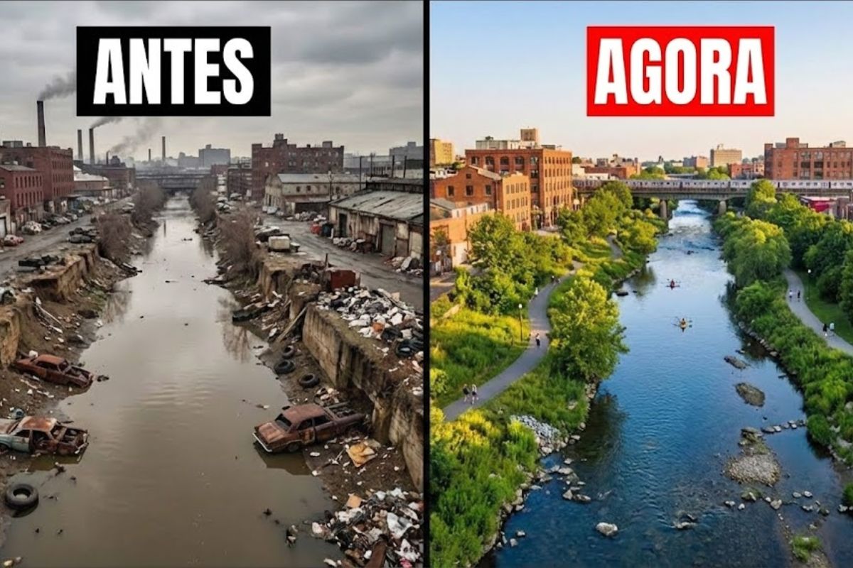


In The Bronx, The River That Was The Most Polluted Waterway In New York Starts To Change With Cleanups, Parks, Greenway Trails, Oyster Reefs Made With Repurposed Shells, And Fish Ladders. The Return Of Beavers And Herring, Monitored, Shows That Urban Ecological Restoration Can Work Right Now.
The river in The Bronx, which was once treated as toxic sewage and an “open sewer,” is becoming a symbol of urban ecological restoration in New York, with parks, trails, oyster reefs, and fish passages reshaping a previously abandoned and dangerous landscape. The return of beavers and herring, absent for generations, is the strongest signal that life is finding its way back.
The transformation did not happen all at once and was not for a single reason. It combines memories of a past when the river sustained Indigenous peoples and abundant wildlife, the collapse caused by decades of industrial pollution and sewage, and a turnaround led by residents, alliances with more than 60 organizations, public investment and ecological engineering solutions that treat water, reopen migratory routes, and restore access to communities.
When The River Was Life, Food, And History

About 300 years ago, the river flowed through dense forests and open fields, crossing a landscape described as Aqua Suspenso, the river of high cliffs, territory where Indigenous peoples fished in clean waters and hunted among ancient trees. Imposing American chestnuts formed a living canopy, shading the floodplain and dropping nuts that fed deer, bears, and countless birds.
-
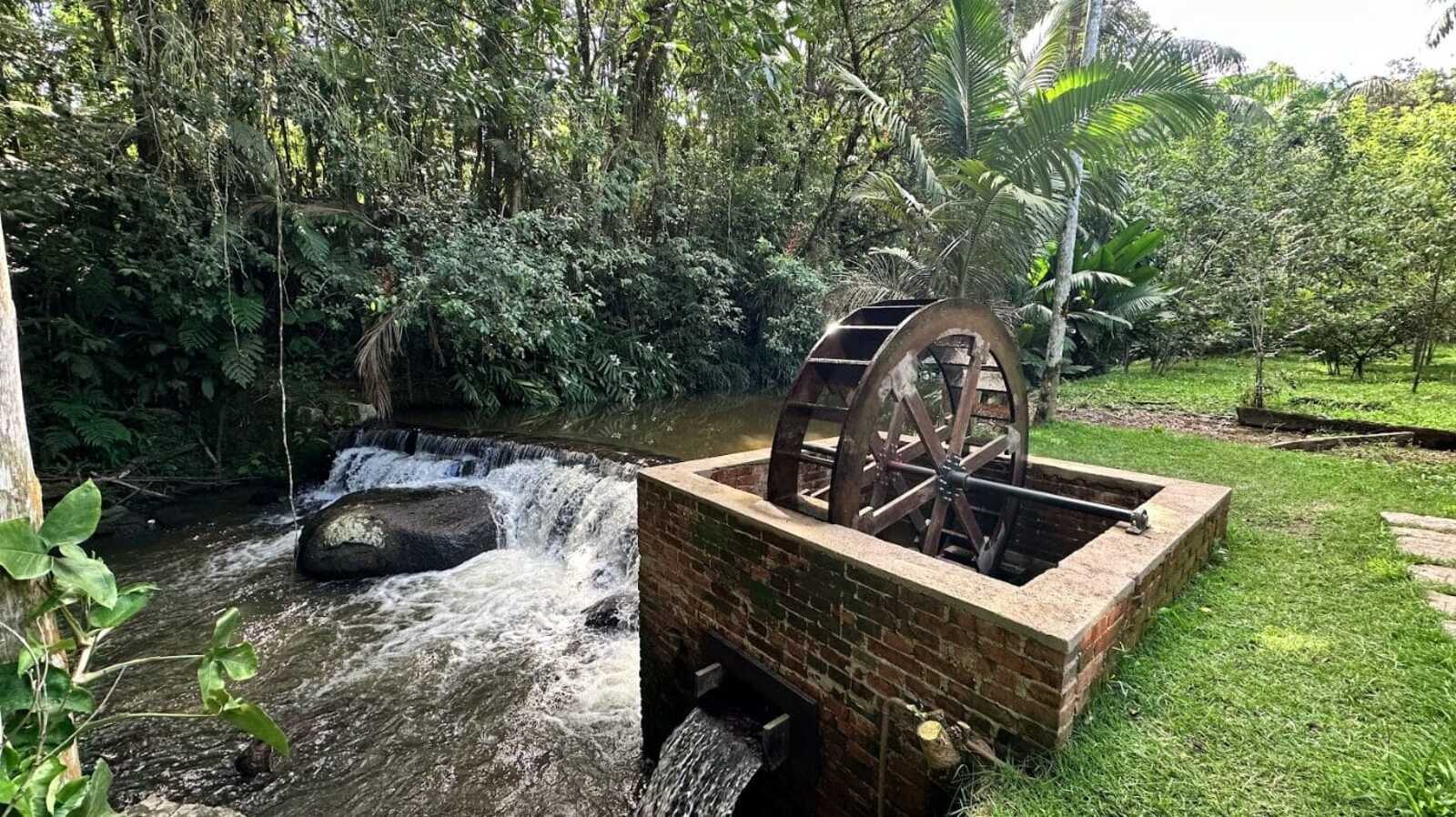
While restoring a historic mansion from 1910, a brick structure with an old turbine that generated energy from the Rio do Testo emerged, along with a hidden door and a rare floor concealed under layers of wax.
-
Italian researchers have detected what appears to be a second Sphinx buried under the sands of Egypt, and satellite scans reveal a gigantic underground megastructure hidden beneath the Giza Plateau for over 3,000 years.

-
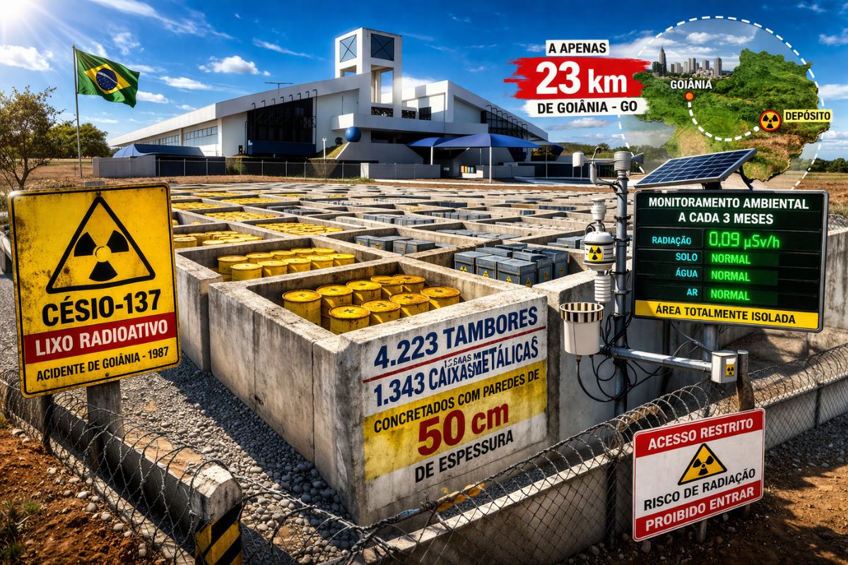
There are 4,223 drums and 1,343 metal boxes concreted with 50-centimeter walls that store the radioactive waste from Cesium-137 in the worst radiological accident in Brazil, just 23 kilometers from Goiânia, with environmental monitoring every three months.
-
Giant Roman treasure found at the bottom of Lake Neuchâtel in Switzerland reveals an advanced trade system, circulation of goods, and armed escort in the Roman Empire about two thousand years ago.


In the riverbed, thick layers of submerged vegetation anchored the bottom, filtered the current, and sustained a web of life that ranged from the smallest insect to the largest predator. Beavers shaped the landscape, building dams that slowed the flow and created quiet pools. Otters slid among the rushes, while eels migrated every spring in numbers that today seem impossible. Herring and shad ascended in masses to spawn, and oysters clustered at the mouth in thick shells, forming natural reefs along the tidal flats.
A Rare River In New York: Fresh Water From Start To Finish

Even with the arrival of fur traders and early settlers in the 1600s, the pulse of the river remained stable for a long time. Mills built in West Farms in the 1670s began harnessing water power without completely crushing its rhythms. The river remained cold and clear, flowing from its source in Keniko and winding for about 23 miles to the East River.
The river was described as the only one that was entirely fresh water in what would become the city of New York, a rarity in a region shaped by brackish tides and saltwater swamps. With each season, the landscape changed with its own spectacle: spring with flowers and birds singing, summer for fishing and bathing, autumn with chestnuts falling by the thousands, and the movement of animals preparing for winter. For centuries, this balance persisted, sustained by the constant flow and the coexistence of those living alongside.
The Collapse At The End Of The 19th Century: The River Becomes A Dumping Canal
By the end of the 19th century, the river no longer resembled the “lifeline” that fed people and wildlife. Factories clustered along the banks, releasing dyes, chemicals, and metal shavings directly into the water. Miles of pipes and industrial drains began carrying waste from tanneries, breweries, and slaughterhouses, clouding the river with oil, blood, and sludge.
The current, once clear and swift, began to lose strength under the weight of debris. After each storm, the city’s sewers overflowed and discharged waves of untreated waste into the canal. The riverbed filled with broken glass, discarded tires, and rotting appliances. The transformation was so complete that by the end of the 19th century, newspapers called the river an “open sewer.” The foul smell dominated the air, fish kills became routine, and wildlife disappeared.
When Wildlife Disappears And Fear Replaces Recreation
The banks, once a gathering and circulation point, became dangerous and avoided areas. Children were warned not to go near the water. With the disappearance of beavers, otters, and herring, which defined the river’s richness, the scene was taken over by rats and clouds of mosquitoes in stagnant pools.
The damage went beyond pollution. The river was also “cut off” from the city by construction, losing physical connection with the communities.
The degradation began to reflect the crisis of the neighborhoods around it, with few parks, frequent dumping, and areas turned into informal dumping grounds.
Highways, Fences, And Concrete: The River Disappears From The Bronx Map
In the 20th century, a new wave of construction isolated the river from those who depended on it. Highways and parkways cut through neighborhoods, pushing the river behind fences and fill.
The Bronx River Parkway, built in the 1920s, aimed to create a “buffer” against abuse, but it also reduced public access.
In the 1960s and 1970s, the tangle of expressways and rail lines turned the river into a forgotten barrier, hidden behind concrete walls and overgrown lots. For about 1.4 million Bronx residents, the river became a symbol of neglect.
Official reports classified the water as unsafe for any use. Illegal dumping sites thrived, with old furniture, car parts, and even entire vehicles abandoned along the banks.
Nine Dams And A Historic Blockage For Fish And Eels
Another obstacle was structural: nine dams, built over decades to power mills and control floods, blocked the passage of fish and eels, interrupting ancient migratory routes. Populations of eels fell to a fraction of what they once were, and the river lost part of its natural cycle.
This blockage was not just a biodiversity issue. It was a symbol of how the river had been turned into broken infrastructure, disconnected from its ecological role.
1974: Residents Say “Enough” And Start Cleaning The River By Hand
In the spring of 1974, a small group of neighbors gathered at the river’s edge and faced a canal choked with trash and forgotten by the city.
Ruth Anderberg, a local resident and former teacher, was among them. She didn’t just see floating tires and appliances stuck in the bed, but the possibility of a living river coming back.
The group called themselves the Bronx River Restoration Project. Without formal support, without an agency “embracing” the cause, they began weekend cleanups, pulling shopping carts, rusty bicycles, and bag after bag of trash.
Each bag collected felt like a promise fulfilled, and the news spread among neighborhoods: students, retirees, parents with children, and volunteers arrived with the idea that the river could belong to the people again.
1979: The Wall Of Tires And The Turnaround That Became A Local Legend
Persistence culminated in a milestone in 1979: the removal of a massive “tire wall” in West Farms Rapids.
Sixty-three young people from the Youth Conservation Corps spent the summer stacking hundreds of old tires to build a retaining wall measuring 600 feet long.
The project stabilized an eroding bank and transformed an informal dump into a park edge. It was not just cleanup; it was a public demonstration that the tide could be turned, even when the city treated the river as a lost cause.
1980s Onward: Restoration Becomes Coalition And Public Policy
By the early 1980s, it became clear that the problem was too big for a single neighborhood group. The difficulties crossed municipal borders and required resources beyond what volunteers could provide.
Nancy Wallace, a councilwoman from White Plains, advocated for government accountability and long-term investment, helping to shift the debate from local activism to regional action.
By the late 1990s, the Bronx River Working Group was born, bringing together more than 60 organizations, schools, churches, environmental groups, and city agencies.
This alliance coordinated projects, shared knowledge, and designed a vision for the entire length of about 23 miles of the river.
In 2001, the Bronx River Alliance was launched as an organization dedicated to managing restoration, education, and community programs.
Money Changes Scale: Nearly $30 Million And Professional Teams
Securing funding was a battle, but the landscape changed when Congressman José Serrano, representing the South Bronx, became a decisive ally.
He advocated for federal investment, linking the health of the river to the well-being of 1.4 million Bronx residents. The result was the guarantee of nearly $30 million in federal resources for river recovery.
This money changed the scale of what was possible: it allowed for hiring professional teams, purchasing specialized equipment, and pursuing ambitious projects that weekend cleanups alone could not sustain.
Parks, Greenways, And Trails: The River Is Accessible Again
With a strong coalition and resources, regaining access became a priority. Abandoned spaces were converted into parks and green corridors.
The Bronx River Greenway began to take shape, connecting neighborhoods with miles of walking and biking trails.
These paths did more than bring back nature. They “stitched” communities that had been separated by highways and neglect. The river ceased to be a barrier and became a pathway again.
Canoes, Kayaks, And Education: People Back In The River Again
Physical restoration came along with public engagement. Free river recreation programs invited families, students, and residents to experience the water.
On weekends, canoes and kayaks began to traverse stretches where trash had once floated, and people observed herons and turtles in areas with replanted banks.
Educational programs took school classes to the banks, teaching ecology, care, and the living history of the river.
Water quality monitoring, removal of invasive species, and cleanup days gave people direct participation in recovery. The river became a classroom, park, and laboratory all at once.
Eel Passages And Fish Ladders Reopen The River From Within
The nine dams remained barriers, so engineers and ecologists designed specific solutions.
Eel passages were created as narrow, wet ramps with rough surfaces, allowing juvenile eels to ascend while bypassing vertical drops.
Fish ladders were installed beside the largest barriers, creating a series of pools in steps that slow the current and provide resting and jumping points for herring and shad.
These structures restored access to over 7 miles of spawning habitat that had been blocked for centuries. The river began to function as a migratory corridor again.
Oyster Reefs: Restaurant Shells Become Living Filters
Oyster reefs were added along the bottom of the river using shells collected from New York restaurants.
Each shell was cleaned, safety tested, and “seeded” with live oysters before being anchored in the bed.
An adult oyster can filter between 30 and 50 gallons of water per day, removing sediments, bacteria, and even microplastics from the current.
As the reefs grow, they not only help purify the water but also create shelter for juvenile fish, crabs, and eels, rebuilding the food web from the bottom up. It’s eco-technology made from life.
Restored Banks: Less Erosion, More Habitat, Less Dirt Flowing Into The River
Bank stabilization projects replaced eroding slopes with the planting of native species and wooden structures designed to reduce runoff and create habitat along the edge.
These interventions were guided by careful measurements and adaptive design, transforming difficult sections into living corridors in a residential area.
The science behind each intervention began to consider flow, depth, filtering capacity, and the slow return of species once thought lost. The river has come to be treated as a system, not a ditch.
Beavers Return After More Than A Century And Change The River’s Status

In tranquil hours before dawn, cameras captured the unmistakable silhouette of a beaver gliding into the river.
For the first time in over a century, this “ecosystem engineer” had returned, drawn by cleaner water and refuge from restored banks.
The presence of the beaver is more than just curiosity. Beavers require healthy habitat, stable banks, abundant trees, and clean water enough to sustain plants and insects.
When the beaver returns, it is “signing” that the river is alive. And by building dams, it helps create wetlands, reduce erosion, and make space for other species.
Herring Swim Up The River, And The Return Is Measured With Technology
Further down, biologists and volunteers gathered to release juvenile herring, such as alewife, a species that had disappeared from these waters generations ago.
The effort didn’t just stop at releases: improvements in fish passages and ladders at key dams allowed herring to reach spawning areas that had been blocked for centuries.
Every spring, the river returns to flashes of silver, with herring swimming upstream. This return is monitored with electronic counters and environmental DNA surveys.
The river has regained its migratory rhythm, and now this rhythm is tracked in detail.
Health Indicators: What Beavers, Oysters, And Herring Say Without Speaking
These species are not just “pretty for pictures.” They function as indicator species, organisms that reveal the health of a system. The beaver signals stable banks and water capable of sustaining complex life. Oysters filter and create the food base. Herring feed birds, mammals, and larger fish, connecting the river to the Atlantic and strengthening the entire ecosystem.
When these pieces return, restoration ceases to be theory and becomes biology happening, with effects rippling throughout the food chain.
From A Symbol Of Neglect To A Global Showcase Of Urban Ecological Restoration
The rebirth of the river in The Bronx questions how cities define progress. With climate threats intensifying, restoring natural systems is not nostalgia, it’s survival.
In a neighborhood with 1.4 million people surrounded by concrete, every improvement in water, bank, and biodiversity changes the quality of life and urban resilience.
What was once a corridor of contamination and disconnection has turned into a laboratory for urban renewal: parks, trails, recreation, education, ecological engineering, and species return combined to prove that even an urban river thought lost can begin to pulse again.
Do you think other major cities will be able to make a river come back this way, or is there still a lack of political courage and continuity to transform abandoned rivers into public pride?


Diferente da realidade do Brasil, onde governo faz discurso de palanque, perante o mundo, preservar a floresta Amazônica, infelizmente o brasileiro continua urinando e defecando na água que bebe, não há saneamento básico no Brasil. Rios e lagos doentes .
Que todas as sociedades possam se unir para construirmos um planeta mais saudável, restaurando e preservando a natureza como grande prioridade!