 Portuguese
  English
  Spanish
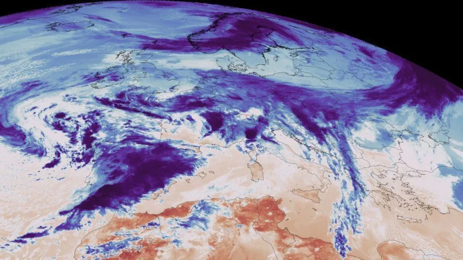
The First Images Released By The New European Meteorological Satellite Show The Earth In Full Disk And Inaugurate A New Phase In Atmospheric Observation, With Direct Impacts On Weather Forecasting, Monitoring Extreme Events And Nowcasting On A Continental Scale
The first images captured by the MTG-S (Meteosat Third Generation – Sounder), developed under the third generation Meteosat program, mark a historic advance in weather observation from space. Positioned in geostationary orbit at approximately 36 thousand kilometers above sea level, the satellite revealed the Earth in full disk with a level of atmospheric detail previously unprecedented for this type of orbit.
Registered on November 15, 2025, the images were officially presented during the European Space Conference, held in Brussels. The information was released by the European Space Agency (ESA), which highlighted the potential of the MTG-S to transform the way meteorologists analyze temperature, humidity, and atmospheric dynamics over Europe, North Africa, and adjacent regions.
Unprecedented Images Reveal Temperature, Humidity, And Atmospheric Fronts In Almost Real Time

Obtained by the Infrared Sounder instrument, the first images show detailed variations in temperature and humidity throughout the atmosphere. In the thermal map, dark red tones indicate warmer areas, while blue tones represent cooler regions, typically associated with cloud tops and active weather systems.
-
With a cost per shot close to zero, the DragonFire laser could change naval warfare in 2027 and provide British ships with nearly unlimited defense against drones.

-
A British startup creates tires that generate electricity in electric vehicles when passing over potholes, speed bumps, and cracks.

-
Scientists have created robots made with living cells that have their own nervous system, swim on their own, explore the environment, and self-organize without any genetic engineering, and now they want to do the same with human cells.

-
Students create a solar-powered ambulance that operates without a plug, without fuel, and still keeps medical equipment running in remote areas.

The data highlight, for example, the intense heat over the African and South American continents. The West African coast, particularly in the Dakar region of Senegal, stands out in dark red. In contrast, the west coast of Namibia and South Africa appears covered by cool clouds, while the northeast of Brazil is also prominent among the areas of highest temperatures observed.
In a second image, focused on atmospheric humidity, the instrument utilizes mid-wave infrared channels. In this image, blue indicates higher humidity concentration, while red represents drier conditions. The driest regions are clearly visible over the Sahara Desert, the Middle East, and an extensive dry area in the South Atlantic, while zones of high humidity are visible over the eastern Africa and at various latitudes across the planet.
Monitoring Extreme Events And Eruptions Marks A New Era In Space Meteorology
In addition to static images, the MTG-S has already demonstrated the ability to monitor extreme events in almost real time. An animation based on satellite data recorded the eruption of the Hayli Gubbi volcano in Ethiopia, which occurred on November 23, 2025. The images reveal variations in surface temperature and highlight the formation and dispersion of the ash plume, allowing for detailed monitoring of the phenomenon over time.
This type of monitoring is considered crucial for aviation safety, protecting nearby populations, and climate analysis, as volcanic eruptions can impact everything from air traffic to atmospheric composition on a regional scale.
According to the ESA’s Director of Earth Observation Programs, Simonetta Cheli, the initial results confirm the transformative potential of the mission. “We expect this data to change the way we forecast severe storms in Europe. This is extremely exciting for society, meteorologists, and climatologists,” she stated.
Unprecedented Technology In Geostationary Orbit Promises To Revolutionize Weather Forecasting
The Infrared Sounder of the MTG-S is the first European hyperspectral sounding instrument to operate in geostationary orbit. Utilizing interferometric techniques, the equipment analyzes extremely small patterns of light waves to measure temperature, humidity, winds, and trace gases in the atmosphere.
In the future, this data will allow for the creation of three-dimensional atmospheric maps, essential for what’s called nowcasting, the prediction of rapidly evolving weather events such as severe storms, heat waves, and intense cold fronts.
According to James Champion, project manager for the MTG at ESA, the satellite is the result of 15 years of technological development. “It will revolutionize weather forecasting. The ability to profile the entire atmosphere vertically with such frequent updates is an extraordinary achievement,” he emphasized.
Furthermore, Pieter Van den Braembussche, manager of systems and payloads for the MTG, explained that the instrument operates with around 1,700 infrared channels. “By combining all these channels, we will be able to generate three-dimensional maps of temperature, humidity, and trace gases, offering a completely new perspective on the Earth’s atmosphere,” he stated.
MTG Mission Expands Weather Coverage And Integrates With The Copernicus Program
Currently, the Meteosat Third Generation (MTG) mission has two satellites in operation: the MTG-I (Imager) and the MTG-S (Sounder). A second satellite from the Imager series is scheduled for launch in 2026, further expanding continuous observation capacity.
The MTG-S was launched on July 1, 2025, with Thales Alenia Space as the main contractor for the mission and OHB Systems responsible for the Sounder satellite. The mission control and data distribution are under the responsibility of Eumetsat, a European organization dedicated to the operation of meteorological satellites.
In addition, the MTG-S hosts the Copernicus Sentinel-4 mission, equipped with an imaging spectrometer for ultraviolet, visible, and near-infrared, which has already begun to provide its first data focused on monitoring air quality and atmospheric composition over Europe.


-

-

-

-

6 pessoas reagiram a isso.