 Portuguese
  English
  Spanish
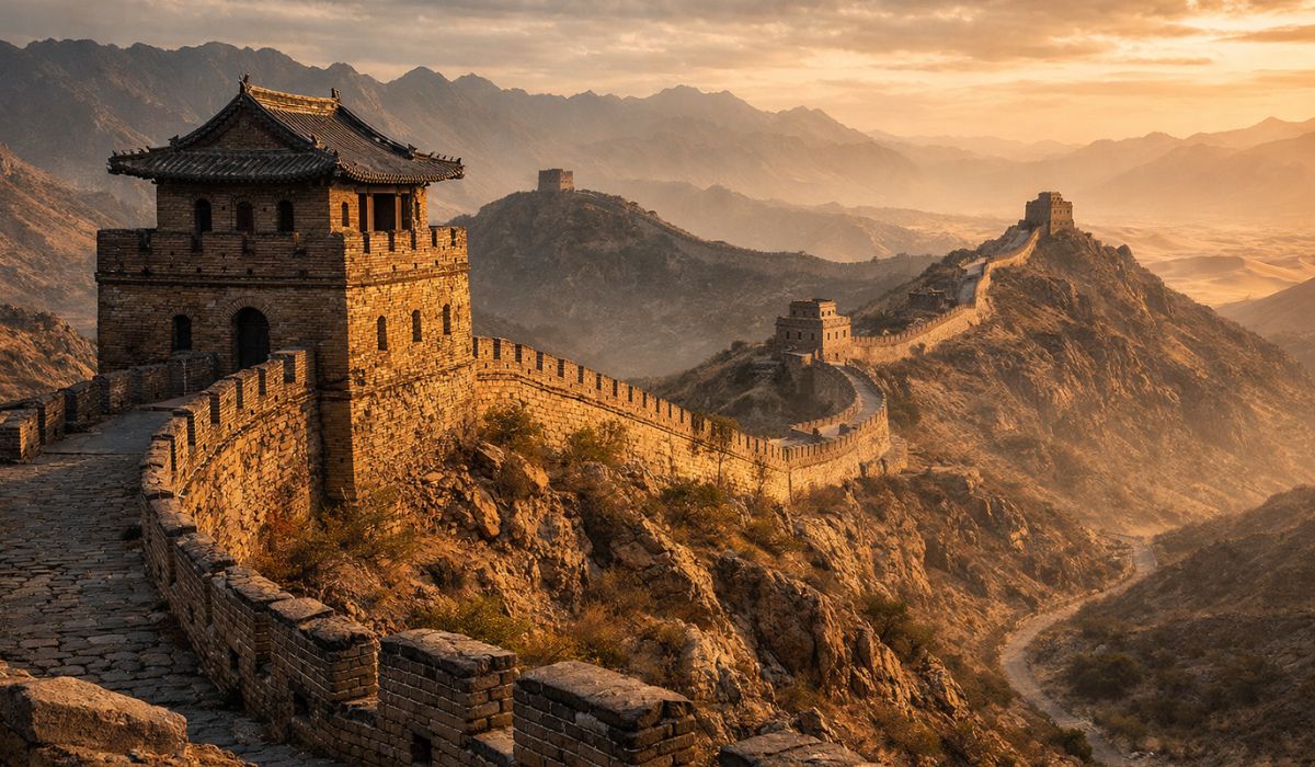
Dispersed structures, military routes, and construction techniques help explain how the Great Wall consolidated as a defensive system of large proportions over different Chinese dynasties.
The Great Wall of China formed, over centuries, a defensive system much more complex than the image of a continuous wall usually suggests.
The ensemble includes walls, trenches, watchtowers, fortresses, strategic passages, and other support points erected by different dynasties.
The most cited official data today indicates a total length of 21,196.18 kilometers when considering all the sections and branches identified in archaeological and cartographic surveys conducted by China.
-
The secret masterpiece of Steve Jobs that took five years to create was blocked before its debut due to an unexpected debt of millions — and the reason behind the blockage in Amsterdam still surprises today.

-
Why is chocolate so “addictive”? Studies show how chemical compounds activate the brain, trigger intense pleasure, and make it difficult to control consumption.

-
Cat owners are now prohibited from leaving them alone for long periods, and a new rule imposes a mandatory routine of care and daily interaction in Sweden.

-
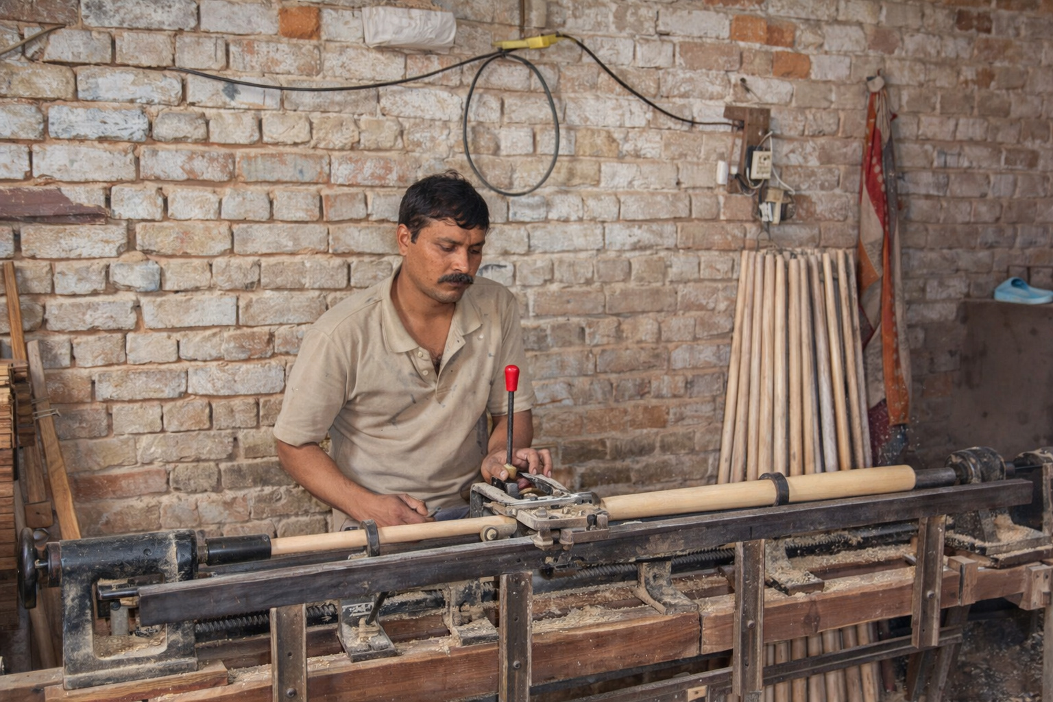
The factory in India produces 70-centimeter pool cues, uses fine wood, combines traditional craftsmanship with modern technology, and excels in global exports.
In the specific case of the Ming dynasty wall, the recognized measurement is 8,851.8 kilometers.
Great Wall of China and the dimension of the defensive system
This consolidated number did not arise from a recent isolated discovery, but from years of work that combined field research, GPS, geographic information systems, and remote sensing.
Satellite images and other mapping resources helped researchers locate worn, buried, or hard-to-observe segments, including in desert and mountainous areas, expanding the understanding of the scale of the fortification.

Academic research on the Ming wall indicates that digital and georeferenced databases have been used to more accurately reconstruct the spatial distribution of this military system.
Fortifications, towers, and passages on the Chinese border
The most accepted description by international organizations treats the Great Wall as a defense system.
According to UNESCO, the heritage includes not only walls but also trails, observation towers, shelters, forts, and passages along the fortified line.
This characteristic helps explain why the structure did not function solely as a physical barrier.
It also articulated surveillance, troop movement, communication, and territorial control over an extensive area of northern China.
During the Ming period, between 1368 and 1644, this model reached one of its most sophisticated stages.
The Encyclopaedia Britannica records that the rulers of the dynasty continuously reinforced and maintained the wall to contain threats from the steppes, especially from Mongol groups.
A study published in 2024 also points out that the logic of deployment followed an operational order: first, forts, passages, and towers were established; then, in many cases, came the continuous sections of wall.
In other words, the military design did not depend solely on the wall itself but on the articulation between various structures distributed across the terrain.
This arrangement helps explain why remote sensing gained ground in the archaeology of the wall.
In regions where erosion, sand, and terrain have hidden parts of the structure, reading through aerial and orbital images allows for the rediscovery of traces difficult to distinguish from the ground.
The resource does not replace on-site verification but has expanded the capacity to locate defensive lines, passages, and occupation marks associated with the imperial border.
Military logistics and supply in the Ming dynasty
Maintaining the wall in operation required more than labor to stack bricks and stones.
The central challenge was to sustain garrisons, transport materials, organize routes, and ensure supply in dry, cold, or mountainous areas.
Research on the Chinese border indicates that the tuntian system, aimed at military agriculture, was adopted by successive dynasties as a policy of occupation and supply in border regions.
This model associated defense and agricultural production, reducing dependence on long supply chains.
In practice, this meant that the sustainability of the system relied on cultivated lands, granaries, support points, and constant circulation between fortresses.
Academic studies on the Ming wall show that the construction and distribution of the sections followed military districts and strategic defense decisions.
It was not, therefore, an isolated work in a vacuum, but an infrastructure connected to settlements, troops, and regional administration.
In passages known as Jiayuguan, in the far west, the military function coexisted with the circulation of people and goods.

UNESCO places Jiayuguan as the western terminal point of the wall.
Historical records and promotional materials related to the local heritage indicate that the pass also operated as an important link in the ancient Silk Road.
This overlap between defense and economic flow helps understand why the wall influenced the development of urban centers and exchange zones in its area of influence.
Materials of the wall and construction techniques
The durability of the Ming sections is linked, in part, to the materials used.
The scientific literature on historical Chinese mortars records the use of mixtures based on lime and glutinous rice, popularly known as sticky rice mortar.
Studies cited by scientific journals and recent works in the field of conservation show that this type of compound was widely used in important structures of ancient Chinese architecture, including walls and masonry works.
At the same time, experts observe that the Great Wall was not built with a single material from start to finish.
The difference between historical periods helps avoid generalizations.
Old sections were erected with compacted earth and materials adapted to the local environment.
In the Ming phase, segments of brick and stone gained prominence, especially at points of greater strategic value.
The academic survey on the Ming wall details that the measurement of 8,851.8 kilometers includes artificial walls, trenches, and natural barriers.
This data reinforces the need to understand the work as a territorial system, and not as a uniform line of masonry.

Forced labor, border, and historical legacy
The monumentality of the wall coexists, since Antiquity, with the record of human suffering.
UNESCO highlights that the construction of the work became a recurring reference in Chinese literature also because of the deprivations imposed by projects of this scale.
There is historical consensus that the wall mobilized large contingents of workers over many dynasties.
However, there is no single, official, and conclusive count that allows for a secure total of people involved throughout its history.
The available documentation allows us to affirm that the Great Wall condensed centuries of compulsory labor, military mobilization, constructive knowledge, and state strategy.
Its material legacy continues to be reviewed as new mapping technologies reveal how fortresses, towers, passages, and defensive lines articulated in the landscape of northern China.


Seja o primeiro a reagir!