 Portuguese
  English
  Spanish
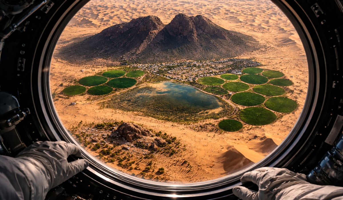
Image made from space highlights an oasis in the Saudi desert, circular cultivation areas, vestiges of an extinct lake, and an internationally recognized archaeological site, gathering in the same scenario geographical, hydrological, and historical elements of long duration.
An image taken by an astronaut aboard the International Space Station has once again highlighted Jubbah, an oasis in northern Saudi Arabia surrounded by dunes, circular cultivation areas, and a relief that, according to NASA, helps reduce the advance of sand.
Viewed from space, the city occupies the basin of an ancient lake in the Nafud desert and gathers, in the same scenario, irrigated agriculture, vestiges of ancient human occupation, and a set of rock art recognized by UNESCO.
In the photo, Jubbah appears as a point of permanent occupation in a hyper-arid region.
-
Seen from space, an image taken by an astronaut shows an unlikely oasis in the Saudi Arabian desert, protected by a terrain that slows the advance of sand, surrounded by green circles, remnants of an extinct lake and nearly 10,000 years of preserved history.
-
Support during childbirth advances in Brazil and strengthens the role of doulas: expectant mothers gain more comfort, guidance, and support from the beginning to the postpartum period.

-
Independence from an early age, plenty of time outdoors, and zero pressure for performance: the Dutch method of parenting has produced the happiest children on the planet and challenges everything other countries believe is necessary for good education.

-
A view from space in a NASA image shows a gigantic volcanic crater 1 km wide in the middle of the Sahara, revealing a frightening formation that resembles a giant skull looking out into the universe and turning the desert into an otherworldly landscape.

The presence of groundwater explains the local agricultural activity and the green circles visible in the image, formed by center pivot irrigation systems.
According to institutional records about the area, this water availability helped sustain settlement over time.
Jubbah and the paleolake in the Nafud desert
According to NASA, Jubbah was built in the basin of a paleolake, a term used to designate a lake that existed in the past and dried up after climate changes.
This ancient body of water measured about 20 kilometers long by 4 kilometers wide.
Today, the remaining bed is “hundreds of feet” below the neighboring dunes, which helps explain the depressed shape of the landscape in which the city is situated.

In the western portion of this depression lies Jabal Umm Sinman, a mountain associated with the geographical configuration of the area.
In Saudi tourism promotional material, the name is related to the image of a two-humped camel lying on the ground.
NASA, on the other hand, states that the massif interferes with wind circulation and creates a kind of “wind shadow,” reducing dune formation on the side where Jubbah has developed.
This aspect is pointed out as one of the factors that help explain the permanence of the oasis.
The prevailing winds in the region blow from west to east, and the mountain acts as a physical barrier to the more intense transport of sand.
In an open desert environment, this condition favors the preservation of the area occupied by the city and the cultivation zones.
Groundwater and ancient human occupation in Jubbah
The history of Jubbah is not limited to the orbital image.
Before the more intense desertification of the Arabian Peninsula, the region housed sources of freshwater used by migrating human groups.
In the case of Jubbah, the presence of a subterranean aquifer is pointed out by studies and institutional records as one of the elements that helped maintain the occupation of the area even after the lake disappeared.
Research on the so-called “Green Arabia,” a term used by specialists to describe ancient phases when parts of the now arid peninsula had more humid environmental conditions, includes Jubbah among the relevant sites for reconstructing this past.
The sedimentary basin of the region preserves geological evidence, while the surroundings gather inscriptions and engravings associated with different periods of human presence.
Rock art in Saudi Arabia and UNESCO heritage
The archaeological importance of the area is concentrated mainly in Jabal Umm Sinman.
UNESCO describes the site as a landscape with numerous panels of petroglyphs and inscriptions produced by populations that lived there when the region was still organized around a freshwater lake.
The set is part of the site “Rock Art in the Hail Region of Saudi Arabia”, inscribed on the World Heritage List in 2015, alongside areas in Shuwaymis.

The records include human figures, animals, and inscriptions from different periods.
In academic studies about the oasis, researchers report that the systematic survey of the area recorded 1,249 panels with rock art and inscriptions, as well as 159 archaeological sites distributed across twelve jebels.
UNESCO itself states that the set preserves almost 10,000 years of human history associated with profound transformations in the local environment.
In addition to its archaeological value, this collection is used by researchers to understand environmental changes in the landscape.
The engravings and inscriptions are treated as evidence of human circulation, the fauna present in wetter phases, and the ways successive groups adapted to climate changes.
For this reason, Jubbah is mentioned in studies as an area of interest for both archaeology and environmental reconstruction of the Arabian Peninsula.

What the image made from space shows about Jubbah
The impact of the photo is partly due to the contrast between the visible elements in the scene.
On one side, there are the agricultural circles produced by mechanized irrigation.
On the other, the shadow of the mountain, the belt of dunes, and the signs of human occupation long before the current city emerge.
In this context, the image records the overlap between geology, groundwater, contemporary agricultural use, and archaeological heritage.
For this reason, Jubbah has begun to be mentioned as an example of how orbital images help observe, at the same time, natural characteristics and marks of human occupation.
In the same frame, there are vestiges of an extinct lake, the influence of the relief on the dynamics of the dunes, and an internationally recognized archaeological site.


Seja o primeiro a reagir!