 Portuguese
  English
  Spanish
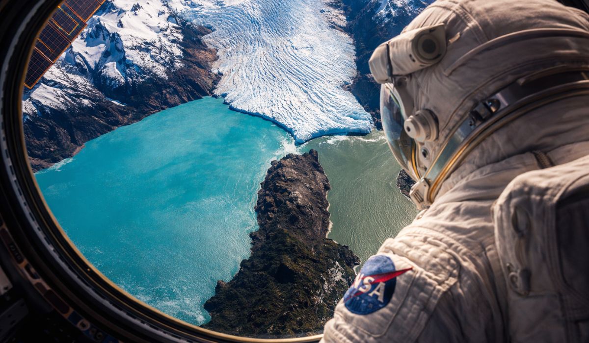
Image made from space highlights an uncommon meeting between ice, water, and relief in Patagonia, Argentina, in a landscape marked by color contrast, glacial dynamics, and environmental transformations accompanied by scientists and international institutions.
A photograph taken by an astronaut from the International Space Station shows the point where the Perito Moreno glacier meets the Argentino Lake and the Brazo Rico, in the southwest of Santa Cruz province, Argentina.
The record was made during the Expedition 64 of the ISS.
In the image, the front of the glacier appears next to the Magallanes Peninsula, a strip of land that separates the main body of the lake from the Brazo Rico and marks the point of contact between ice, water, and relief.
-
Workers are being forced to train the AI that will replace them in their jobs.

-
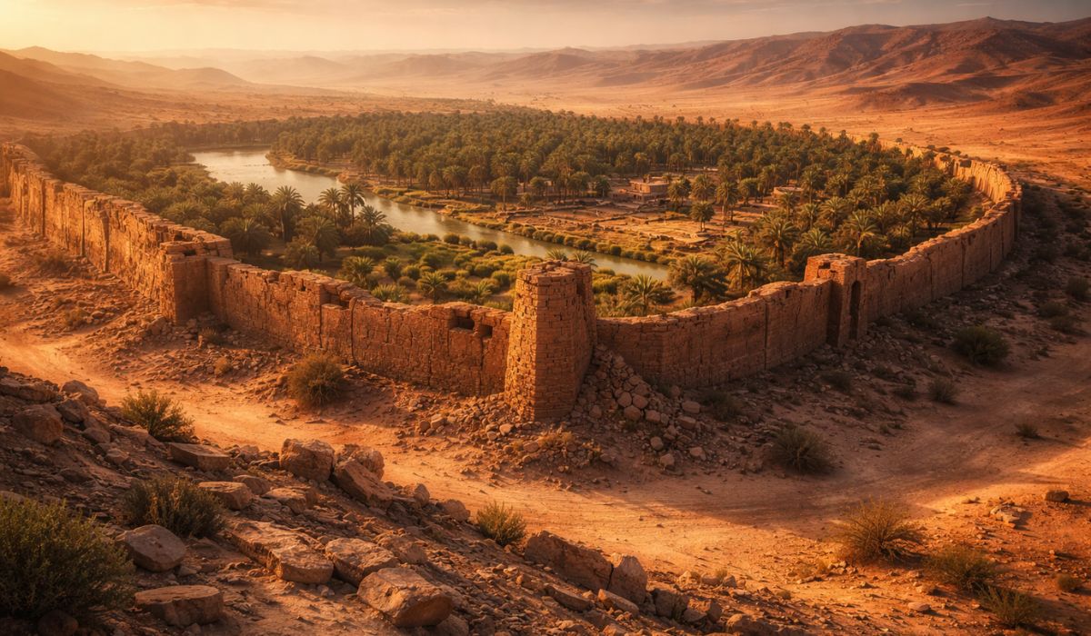
Archaeologists found in the desert an oasis 5,000 years old surrounded by giant walls, in a discovery that reveals a civilization much more complex, powerful, and organized than previously thought.
-
Giving your CPF at the supermarket has become routine, but in 2026 the rule will change: see how your data is used and when it is worth informing.

-
China has launched mysterious invasion barges into the sea with giant ramps that connect like Lego pieces and can form floating bridges of nearly 1 km to transport armored vehicles directly to the beach, in a kind of secret weapon for Taiwan.

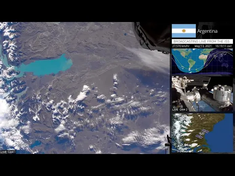
Perito Moreno, Argentino Lake, and the record made from space
The photographed area is located in the Los Glaciares National Park, a conservation unit created in 1937 and recognized by UNESCO as a World Heritage Site in 1981.
According to official data from Argentina, the park preserves more than 726 thousand hectares in the southwest of Santa Cruz and is part of one of the largest glacial areas outside polar regions.
In this system, the Argentino Lake occupies a central position.
The National Geographic Institute of Argentina reports that it has 1,435 square kilometers, making it the largest lake entirely located in Argentine territory.
The bluish and turquoise coloration observed in various sections of the lake is associated with the so-called glacial flour, formed by fine rock particles produced by ice erosion.
In glacial-origin lakes, this material remains suspended and alters the light dispersion in the water.

Brazo Rico and the difference in water color
Despite its elongated appearance and darker aspect in aerial and orbital images, the Brazo Rico is a part of the Argentino Lake.
The impression that it is a river is linked to the periodic isolation of this area when the glacier advances toward the Magallanes Peninsula and reduces communication with the rest of the lake.
Furthermore, studies on the dynamics of the Argentino Lake show that the concentration of suspended sediments varies between different sectors of the system.
This difference helps explain the contrast in tone between the Brazo Rico and other parts of the lake visible in the photograph taken from space.
The blocking and breaking cycle of the Perito Moreno glacier
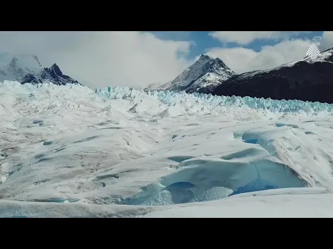
At irregular intervals, the tongue of the Perito Moreno reaches the Magallanes Peninsula and forms a natural ice dam.
When this occurs, the water level in the Brazo Rico can rise up to about 30 meters above the rest of the Argentino Lake, until the accumulated pressure breaks the barrier.
This process is one of the most well-known in the area and has been documented for decades in scientific and institutional records about the glacier.
The break does not occur on fixed dates, but the pattern of blocking and periodic collapse makes the site a recurring case study on the interaction between ice, relief, and water circulation.
The Perito Moreno is about 30 kilometers long, and its front rises more than 60 meters above the surface of the lake.

The ice mass drains into two main sectors of the Argentino Lake, one facing the Canal de los Témpanos and the other toward the Brazo Rico, which explains the importance of the position of the glacial front for the hydrological behavior of the region.
Perito Moreno and the recent signs of retreat
For a long time, the Perito Moreno was treated in studies and outreach materials as an exception among the large Patagonian glaciers, because its front remained relatively stable while other glaciers in the region showed more evident retreat.
This condition helped to consolidate the image of the glacier as an unusual case in the context of the warming observed in recent decades.
However, more recent data indicate a change in this scenario.
A study published in 2025 in the journal Communications Earth & Environment identified an acceleration in the lowering of the surface of the Perito Moreno, with the average rate increasing from 0.34 meters per year between 2000 and 2019 to 5.5 meters per year between 2019 and 2024, along with a retreat of more than 800 meters in some sections since 2019.
Thus, the photograph taken from Earth’s orbit brings together more than three natural features in the same frame.
The image allows us to observe, in a single sector of the park, the contact between the glacial front, the largest lake entirely in Argentina, and a lake arm whose behavior changes when the advance of the ice alters the water circulation.


Seja o primeiro a reagir!