






 Portuguese


Soil in California’s San Joaquin Valley Sunk Nearly 30 Feet Due to Decades of Groundwater Pumping, Compressing Soil and Permanently Reducing Aquifer Capacity
In parts of the San Joaquin Valley, California, the ground has sunk not just a few inches: the terrain has experienced around 30 feet (approximately 9 meters) of subsidence by 1981 after decades of intensive groundwater extraction. According to the U.S. Geological Survey (USGS), large-scale overpumping started in the 1920s, reducing aquifer levels, compressing underground layers of clay and silt, and causing permanent loss of water storage capacity.
The results can be seen in one of the most famous images in American hydrogeological science: a post near Mendota marks where the surface was in 1925, 1955, and 1977, showcasing decades of altitude loss.
The problem persists today. Beyond permanently reducing space within the aquifer system, subsidence has altered channel slopes, decreased the capacity to transport water, and forced authorities to spend on infrastructure in a region reliant on a complex system to supply cities and support agriculture.
-
Hidden in the Primitive Universe, Distant Galaxies Contain Four Times More Mass Than Previously Expected

-
City in Brazil Erodes by 5 Meters Annually, Causing Property Damage and Displacing Families

-
Less Water, More Energy, and the Same Amount of Tomatoes: University Demonstrates That Semitransparent Solar Panels Could Be the Future of Agriculture
-
Submarine desalination 500 meters deep transforms saltwater into 1 million liters of drinking water per day using ocean pressure


The Ground Began to Sink When Thousands of Wells Started Extracting Water from Below
The San Joaquin Valley forms the southern part of California’s Great Central Valley and is among the most productive agricultural areas in the United States. Starting in the 1920s, groundwater became increasingly important for irrigating crops and meeting agricultural production demands that required large volumes even during dry periods.
Initially, the extraction occurred without a full understanding of the vertical consequences. However, as underground levels dropped, measurements began to reveal that the surface was also changing position.

The process gained extraordinary scale. According to the USGS, by 1970 nearly half of the San Joaquin Valley, approximately 13,500 square kilometers, had already sunk more than 1 foot (30 cm). In certain areas, accumulated subsidence exceeded 28 feet (8.5 meters).
Near Mendota, Decades of Pumping Have Caused the Soil to Sink Nearly 30 Feet
The region southwest of the city of Mendota has become the symbol of this phenomenon. The USGS records that some of the most extreme subsidence levels measured in California occurred there.
Between 1925 and 1977, the ground lost over 29 feet of elevation, approximately 8.8 meters. Later documentation records that local subsidence reached around 30 feet (9 meters) by 1981.
This is not a sudden hole nine meters deep; the entire landscape gradually lowered as underground sediments were compressed. Roads, fields, channels, and other structures have followed this vertical movement.
It is precisely this characteristic that makes the phenomenon less visually evident while simultaneously capable of producing enormous impacts over decades.
Pumping Excessive Water Causes Soil Weight to Compress Clay and Silt
The mechanism occurs within the pores of the sediments that form the aquifer system. Subsurface layers store water between particles of sand, silt, and clay. While there is sufficient pressure in the pores, part of the load from the upper layers is supported by the water itself.
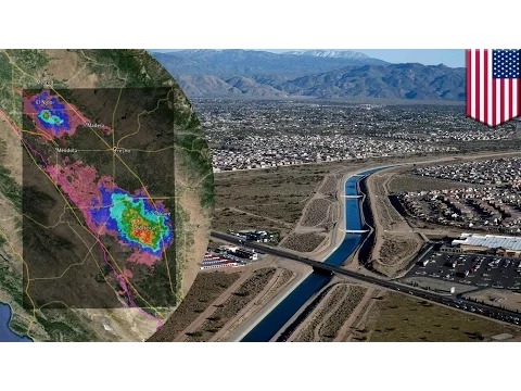

When pumping causes subsurface levels to drop to historically low values, this pressure diminishes. A greater portion of the weight then shifts to the solid structure of the sediments.
The USGS uses a straightforward visual comparison to explain what happens with fine materials: originally relatively disorganized clay particles can be rearranged and compressed, occupying less space.
At the surface, this reduction in volume appears as subsidence.
Some of the Lost Water May Return, but the Destroyed Subsurface Space Does Not Necessarily Return
There is a fundamental difference between elastic and inelastic compression. Under certain conditions, if the water level recovers, part of the subsurface deformation may also be recovered. However, when pumping causes pressure to exceed historical limits, fine sediments can undergo permanent compaction.
This means that the problem does not simply end when it starts to rain again.
When clays are heavily compressed, part of the space that previously contained water ceases to exist. The USGS classifies this reduction in pore volume as a largely unrecoverable loss of the aquifer’s storage capacity.
Thus, extracting too much water can produce an apparently contradictory effect: the aquifer is utilized to bridge a shortage, but the excessive exploitation itself may decrease the amount of water it can store in the future.
The Arrival of Surface Water Managed to Slow Down the Subsidence
The extreme subsidence observed during the first half of the 20th century began to decline when large projects started importing surface water into the San Joaquin Valley.
The Delta-Mendota Canal began supplying water in the 1950s, while the California Aqueduct expanded this supply from the early 1970s. The availability of surface water reduced the need for pumping in certain areas, allowing for recovery of subsurface levels and slowing compaction.
However, the relief did not mean the end of the problem.
Whenever the availability of surface water decreased, farmers and other users returned to relying more heavily on wells.
Major Droughts Caused the Subsurface to Start Giving Way Again
The USGS identified major resurgences of compaction during drought periods, including 1976-1977, 1986-1992, 2007-2009, and 2012-2015.
The pattern was repetitive. Reduced water availability in rivers, reservoirs, and distribution systems led to increased groundwater pumping. Well levels dropped, and in vulnerable areas, clay layers began to compact again.
During the severe drought that began in 2012, radar images analyzed by NASA revealed parts of the San Joaquin Valley sinking rapidly. The agency noted that drought-driven pumping intensified a process that had begun decades earlier.
Satellites Began to Show Subsidence Almost in Real Time
Technology has profoundly changed the ability to monitor the phenomenon. Satellite radar techniques allow for repeated comparisons of surface position and detection of changes of centimeters, or even smaller, over extensive areas.
Between May 2015 and September 2016, data from the Sentinel-1 showed that the San Joaquin Valley continued to exhibit significant subsidence in different pockets.
These measurements are important because subsidence does not occur uniformly. One field may sink faster than a neighboring area, creating elevation differences that alter channels, roads, and other structures.
It is precisely this differential subsidence that transforms a seemingly slow movement into an engineering problem.
By 2023, Subsidence Had Already Reduced 44% of the Capacity of a Portion of the California Aqueduct
The impacts remain measurable decades after the problem was discovered. In November 2025, the California Department of Water Resources (DWR) reported that the levels of subsidence observed in 2023 had led to a 44% reduction in the capacity of the California Aqueduct in the studied area.
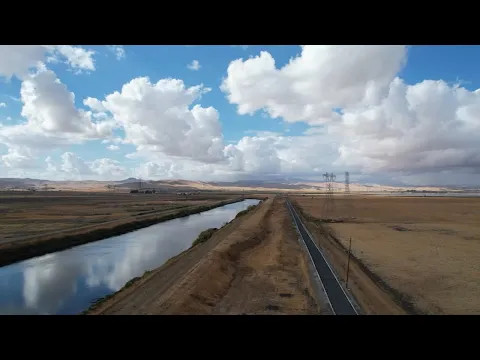
Another example is seen in the San Luis Canal, which is part of the aqueduct system. According to the DWR, some sections have sunk by more than 2.4 meters since they began operating in the 1960s.
The transformation occurs because the canal does not necessarily sink uniformly. Lower sections can limit the amount of water flowing through the system without overflow or other operational issues.
Thus, decades of groundwater pumping ultimately reduce the efficiency of the infrastructure built to transport surface water and lessen reliance on the wells themselves.
The Friant-Kern Canal Lost Capacity Equivalent to Billions of Liters of Water
The Friant-Kern Canal provides another example of the economic and hydric dimensions of the problem.
According to the DWR, by 2017, subsidence exceeding 3 meters in certain locations had reduced deliveries from the canal by approximately 300,000 acre-feet.
This volume corresponds to about 370 million cubic meters, or approximately 370 billion liters.
The USGS also reports that, in some sections, the Friant-Kern Canal was operating at only about 40% of the capacity for which it was originally designed due to the effects of differential subsidence.
Wells, Roads, Bridges, and Dikes Also Fall Within the Risk Zone
Channels are the most visible consequence for the water system, but they are not the only exposed elements.
NASA reports that long-term subsidence has already damaged thousands of public and private wells in the San Joaquin Valley. Aqueducts, dikes, roads, and bridges may also face repercussions when the ground no longer remains at the elevation considered in the original design.
Deformation may also alter river gradients, water depth, and erosion and deposition patterns. This occurs because subsidence changes the very geometry of the landscape.
In a region where agriculture, urban supply, and flood control depend on large-scale infrastructure, even a few accumulated centimeters at different points can have consequences. When the total reaches meters, the problem transcends beyond just geological issues.
California Attempts to Prevent New Withdrawals from Repeating Historical Disaster
The state approved the Sustainable Groundwater Management Act in 2014, known as SGMA, creating a long-term management system for critical aquifers.
The challenge is to prevent groundwater levels from dropping again to values capable of causing significant and permanent compaction.
In January 2026, the Department of Water Resources (DWR) published a specific subsidence management practice to guide local agencies in preventing or reducing subsidence caused by pumping. The document is part of an effort to ensure that the most vulnerable areas do not repeat the historical extremes recorded in the San Joaquin.
The goal is not simply to halt all use of groundwater. Aquifers are vital for traversing dry periods. The issue is to prevent withdrawals from repeatedly exceeding the physical limits that result in the permanent loss of volume in the system.
The 9 Meters Illustrate What Happens When a Water Crisis Also Modifies Geology
The history of the San Joaquin Valley is unusual as it transforms an everyday decision regarding water supply into a physical change of regional scale.
For decades, millions of cubic meters were extracted from aquifers to sustain agriculture and other activities. The response appeared slowly: groundwater levels dropped, fine sediments were compressed, and a part of the surface descended alongside.
By 1970, over 13,500 km² had already experienced subsidence exceeding 30 centimeters. Near Mendota, the total exceeded 8.5 meters and reached approximately 9 meters in 1981.
Decades later, the consequences can still be measured in deformed channels, reduced capacity to transport water, and aquifers that have permanently lost part of the space that previously served to store it.
The ground that has sunk is not just a record of a past crisis. It remains as physical evidence that when groundwater withdrawal exceeds certain limits, a region can deplete not only the water in its aquifer but also part of the very space where that water could return to exist.


