 Portuguese
  English
  Spanish
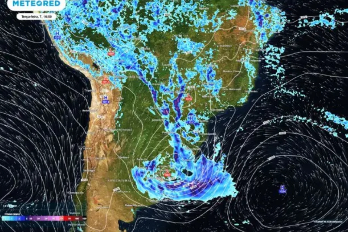
The formation of an extratropical cyclone in the ocean drives a cold front that changes the weather in Brazil, bringing rain, wind, and thunderstorms to the South and Southeast. Santa Catarina is on high alert, while other regions remain unstable and hot.
The arrival of a cold front this Tuesday, April 7, changes the weather in part of Brazil and brings instability to areas of São Paulo, Rio de Janeiro, and southern Minas Gerais. The advance of the system increases cloud cover and opens the way for showers with wind and lightning.
The strongest impact is concentrated in the South of the country, where the rain intensifies and spreads more regularly. In addition to the rain, the scenario also includes drops in temperatures and increased agitation along the coast.
In the Southeast, the day starts with milder temperatures and humid weather in several areas. Throughout the afternoon, the combination of ocean humidity and atmospheric instability favors thunderstorms and gusts of wind.
-
South Korea’s intelligence agency claims to have reliable information that Kim Jong-un’s teenage daughter has already been chosen as his successor and is being prepared to lead North Korea by driving tanks and shooting rifles.

-
At over 2,400 meters above sea level, Pico da Tripla Divisão is a rare mountain where a single drop of rain can take paths that lead to three different oceans.

-
With 75 mutations and confirmed circulation in 23 countries, a subvariant of Covid-19 challenges part of the protection against infection and reinforces the warning about the decline in vaccination.

-
New RG can be delivered by the Post Office in some states, such as São Paulo and Minas Gerais; see how to request it.

São Paulo, Rio de Janeiro, and southern Minas enter the instability path
The forecast for São Paulo, Rio de Janeiro, and southern Minas Gerais indicates showers throughout the afternoon. In several areas, the advance of instability may cause thunderstorms and stronger winds.
The minimum temperatures range between 18 degrees and 22 degrees at the beginning of the day. The maximum temperatures vary between 26 degrees and 29 degrees, with the possibility of reaching 30 degrees in areas of northern Minas and Espírito Santo.
Santa Catarina receives a red alert with volumes between 80 and 130 mm
In Santa Catarina, the scenario is more delicate between Greater Florianópolis, the North Coast, and part of the Itajaí Valley. In these areas, the Civil Defense issued a red alert due to persistent and heavy rain, with accumulations between 80 and 130 mm.
The risk of flooding, flash floods, and landslides increases, especially between night and dawn. This heightens attention in urban areas and also in hillside regions.
Rio Grande do Sul concentrates more widespread and persistent rain
Rio Grande do Sul is among the areas most directly impacted by the cold front. The rain tends to be more widespread and persistent, increasing the potential for disruptions throughout the day.
In Paraná, instability appears more irregularly, but there is still a chance of showers in the southern part of the state. According to O Globo, the Southern Region is expected to feel the more organized effects of the system.
Central West maintains irregular showers with greater intensity in Mato Grosso
In the Central West, humidity from the Amazon continues to feed areas of instability. As a result, the weather remains irregular in much of the region.
The more frequent showers are concentrated in Mato Grosso and northern Mato Grosso do Sul. In Goiás and the Federal District, rain appears more isolated, mainly during the afternoon.
Northeast has light rain on the coast and drier inland
The coastal strip of the Eastern Northeast continues with light and passing rain. This behavior is typical for early April and maintains the pattern seen in recent days.
In the interior, the weather remains drier with few changes. This reduces the chance of abrupt changes outside the coastal strip.
North continues with heat, high humidity, and localized storms
In the North Region, heat and high humidity continue to prevail. This environment favors frequent rain, especially in Amazonas, Acre, Rondônia, and western Pará.
In addition to the rainfall volumes, there is a possibility of thunderstorms and gusts of wind in different areas. The feeling of heat remains strong and keeps discomfort prevalent in much of the region.
The combination of extratropical cyclone, cold front, and high humidity spreads instability across different areas of the country this Tuesday, April 7. The immediate impact is seen in the more intense rain in the South and the showers with wind in the Southeast.
With a maximum alert in Santa Catarina, high risk of disruptions and temperature drops in part of the map, the advance of the system pressures the region.


Seja o primeiro a reagir!