 Portuguese
  English
  Spanish
European Meteorological Center projections indicate above-average rainfall in almost all of Brazil in the next ten days, with volumes reminiscent of the summer rainy season. The highest accumulations are expected to reach the Southeast (São Paulo, Rio de Janeiro, and Minas Gerais), the northeast coast from Pernambuco to Maranhão, and the northern states still under the influence of the Amazonian winter.
The forecast is clear: above-average rainfall in almost all of Brazil in the next ten days. According to the metsul portal, projections from the European Meteorological Center (ECMWF) model, analyzed by MetSul Meteorology, indicate that above-average rainfall accumulations in April will reach volumes reminiscent of the peak of the summer rainy season, not what one would expect at the beginning of autumn. The scenario is particularly concerning for those living in the Southeast, Northeast, and North regions, where the volumes are expected to be more intense.
The situation is unusual for April. Instead of the transition pattern to a drier period, Brazil is entering the next ten days with above-average rainfall across much of the territory, with locally high to very high accumulations in several regions. The North is at the peak of the Amazonian winter, the Northeast is influenced by the ITCZ, and the Southeast is projecting elevated volumes in three of its main states. Even the South, although irregular, will have points with precipitation above what is expected.
North of Brazil: Amazonian winter keeps above-average rainfall with heavy volumes
The North Region remains in the Amazonian winter period, the rainy season that runs from December to mid-May, concentrating between 60% and 70% of all annual precipitation.
-
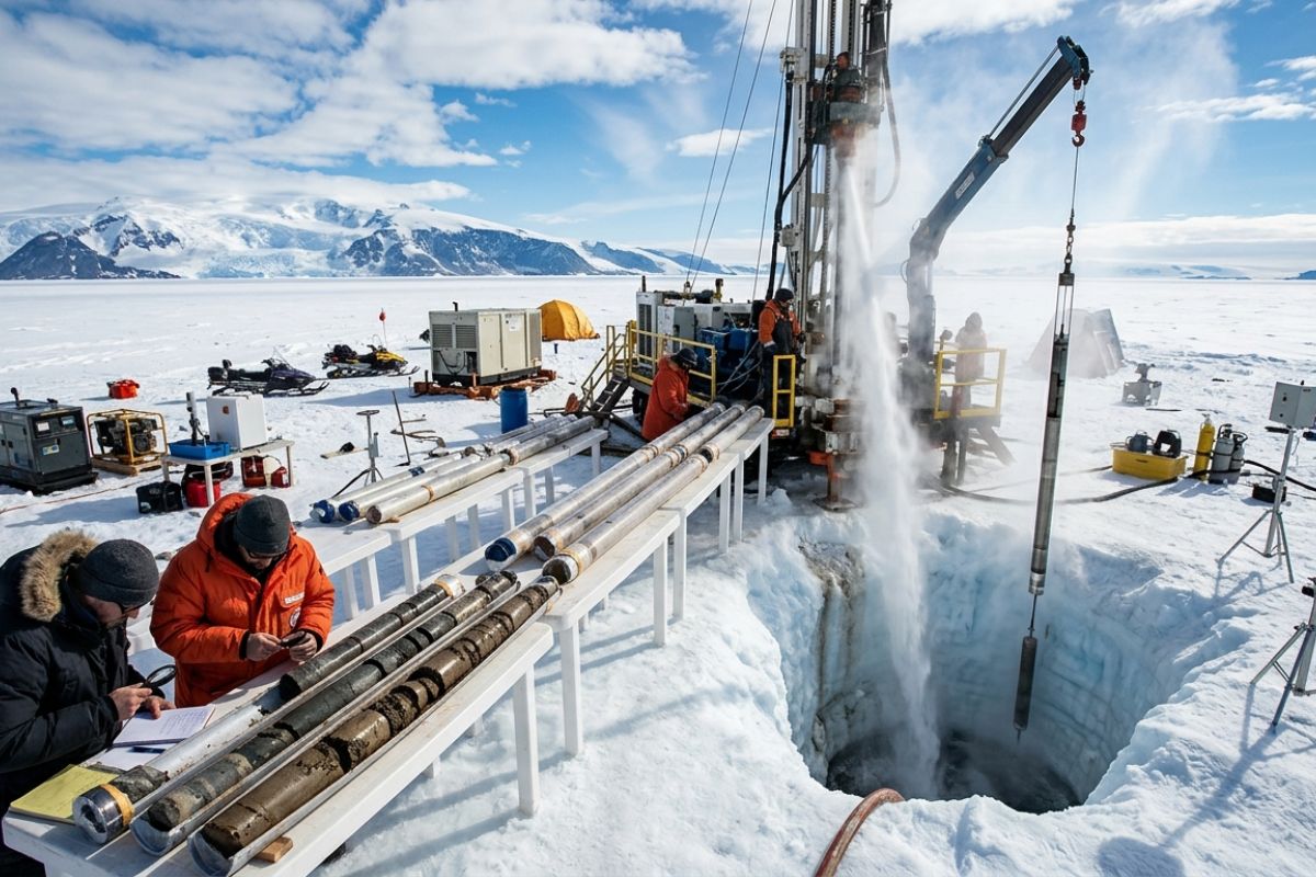
With pressurized hot water, scientists melt 523 meters of ice in West Antarctica and extract a 228-meter rock core with a record of 23 million years, revealing ice-free periods and global warnings.
-
Denmark resumes the idea of building the world’s first energy island with $30 billion, connecting several countries and changing the European energy game amid uncertainty due to the war in Iran.

-
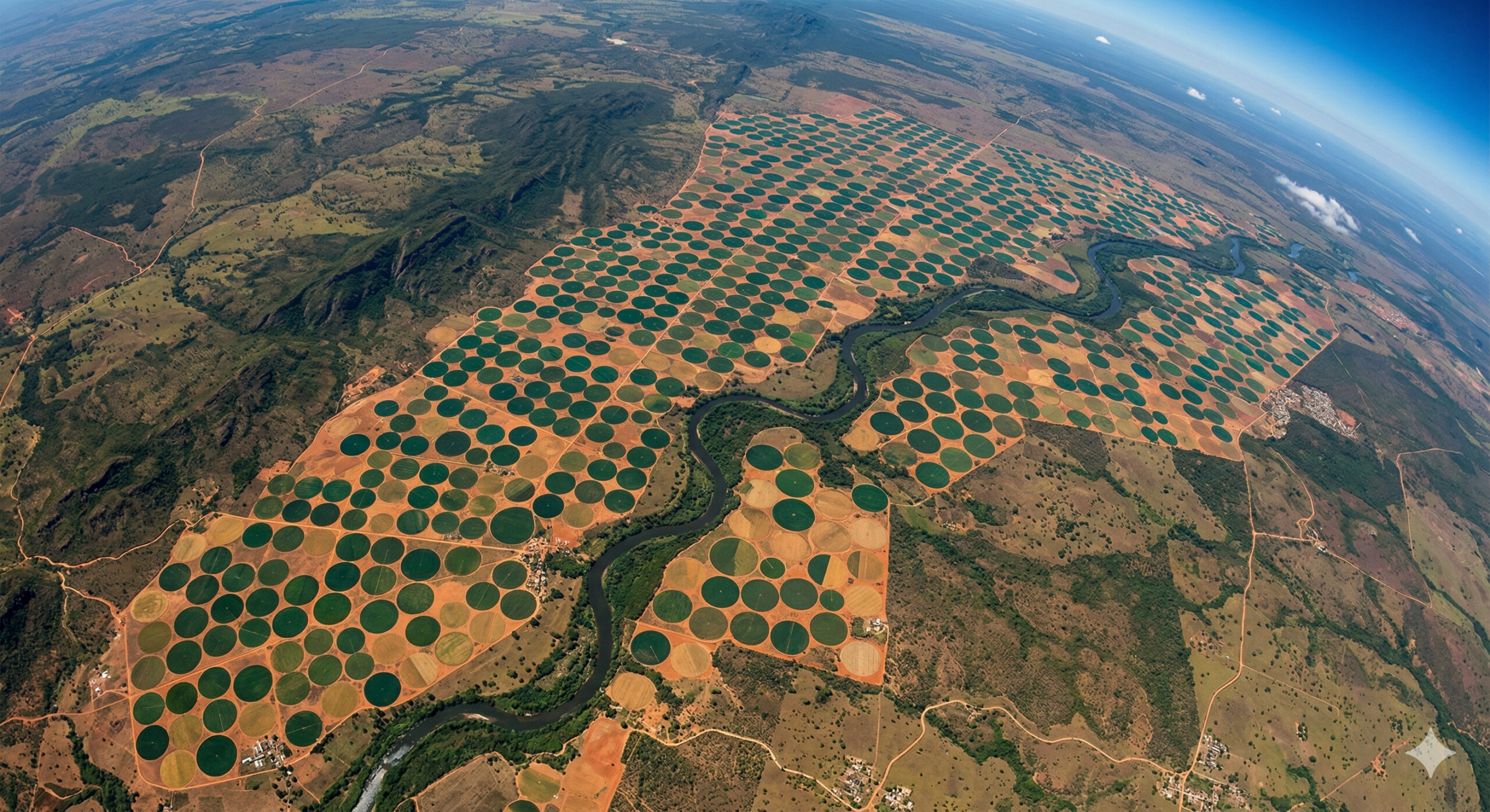
In the interior of Bahia, gigantic “perfect” circles drawn on the land appear from space as targets kilometers in diameter, revealing irrigation systems so precise that they transform crops into geometric patterns visible from orbit.
-
The heatwave in Brazil that hit in March is set to end as a cold front arrives between Good Friday and Easter Sunday, causing a temperature drop of up to 6 degrees and rain in the Central-South region, according to the Easter weather forecast.


In the next ten days, above-average rainfall is expected to mainly affect Amazonas, Pará, Roraima, and Amapá, with high volumes also in other states in the region. This is the period when it historically rains the most in the North, and projections indicate that 2026 will be no exception.
Amapá and Roraima are still under the influence of the Intertropical Convergence Zone (ITCZ), a phenomenon that brings atmospheric instability around the equator and reinforces the pattern of above-average rainfall in the region.
For riverside communities, flood-prone areas, and cities with poor drainage infrastructure, the combination of the Amazonian winter with an active ITCZ can mean days of intense and continuous rain.
Northeast: above-average rainfall on the coastal strip from Pernambuco to Maranhão
A large part of the Northeast is expected to register increased precipitation in the next ten days, with volumes that can be locally high to very high.
The above-average rainfall in the Northeast will be more intense in the northern portion of the region, especially along the coastal strip from Pernambuco to Maranhão, which is precisely the most populous area with the highest urban concentration along the northeastern coast.
For cities like Recife, São Luís, and Fortaleza, the forecast of above-average rainfall deserves extra attention.
The history of flooding, landslides, and urban disruptions in the Northeast during periods of intense rain makes it essential for residents to follow Civil Defense alerts and avoid risk areas during days of heavier precipitation. The expected rain is not isolated; it spans ten days of consistently above-normal volumes for April.
Southeast: São Paulo, Rio, and Minas Gerais among the states with the highest volume of above-average rainfall
In the Southeast, precipitation accumulations are expected to significantly exceed the normal for April. The highest volumes of above-average rainfall are forecasted for São Paulo, Rio de Janeiro, and Minas Gerais, specifically in the Triângulo Mineiro and the southern part of the state.
The scenario is more reminiscent of the peak of summer than the beginning of autumn, with rain distributed over ten days and volumes that may cause impacts.
For the Southeast, above-average rainfall in April is concerning because many cities have already faced flooding and landslides during the summer season, and the soils may be saturated.
The soil’s absorption capacity decreases when it has already received high volumes in previous months, causing each new rain to drain more quickly into rivers, streams, and stormwater drains. São Paulo, Rio, and southern Minas are the areas that require the most vigilance in the coming days.
Midwest and South: above-average rainfall too, but with irregular distribution
In the Midwest, above-average rainfall for April is expected to be distributed across much of the region in the next ten days, although the volumes will vary significantly from one point to another.
Even with the irregularity, accumulations are expected to be locally high enough to cause disruptions in urban and rural areas that typically do not expect such heavy rainfall at this time of year.
In the South of Brazil, precipitation will be quite irregular and with great variability in volumes. There will be isolated points with above-average rainfall in Rio Grande do Sul, Santa Catarina, and Paraná, but without the widespread pattern of intense rain projected for the North, Northeast, and Southeast.
Still, localized storms can cause specific problems, especially in urban areas with poor drainage.
Ten days of above-average rainfall in April: what to expect and how to prepare
The projected scenario for the next ten days is atypical for April: above-average rainfall in almost all of Brazil, with volumes reminiscent of the peak of summer.
North under Amazonian winter and ITCZ, Northeast with intense precipitation on the coast, Southeast with elevated accumulations in São Paulo, Rio, and Minas, and Midwest and South with irregular but locally significant rainfall.
Monitoring weather alerts, avoiding risk areas during heavy rain days, and being extra cautious while driving are basic measures that make a difference.
Above-average rainfall is not necessarily a catastrophe, but when it affects the entire Brazil for ten consecutive days, the accumulation can be surprising.
Did the forecast of above-average rainfall catch you by surprise? Is it raining more than normal in your city? Share in the comments how the weather is in your region and if you’ve already felt the impact.


Seja o primeiro a reagir!