Portuguese
  Spanish
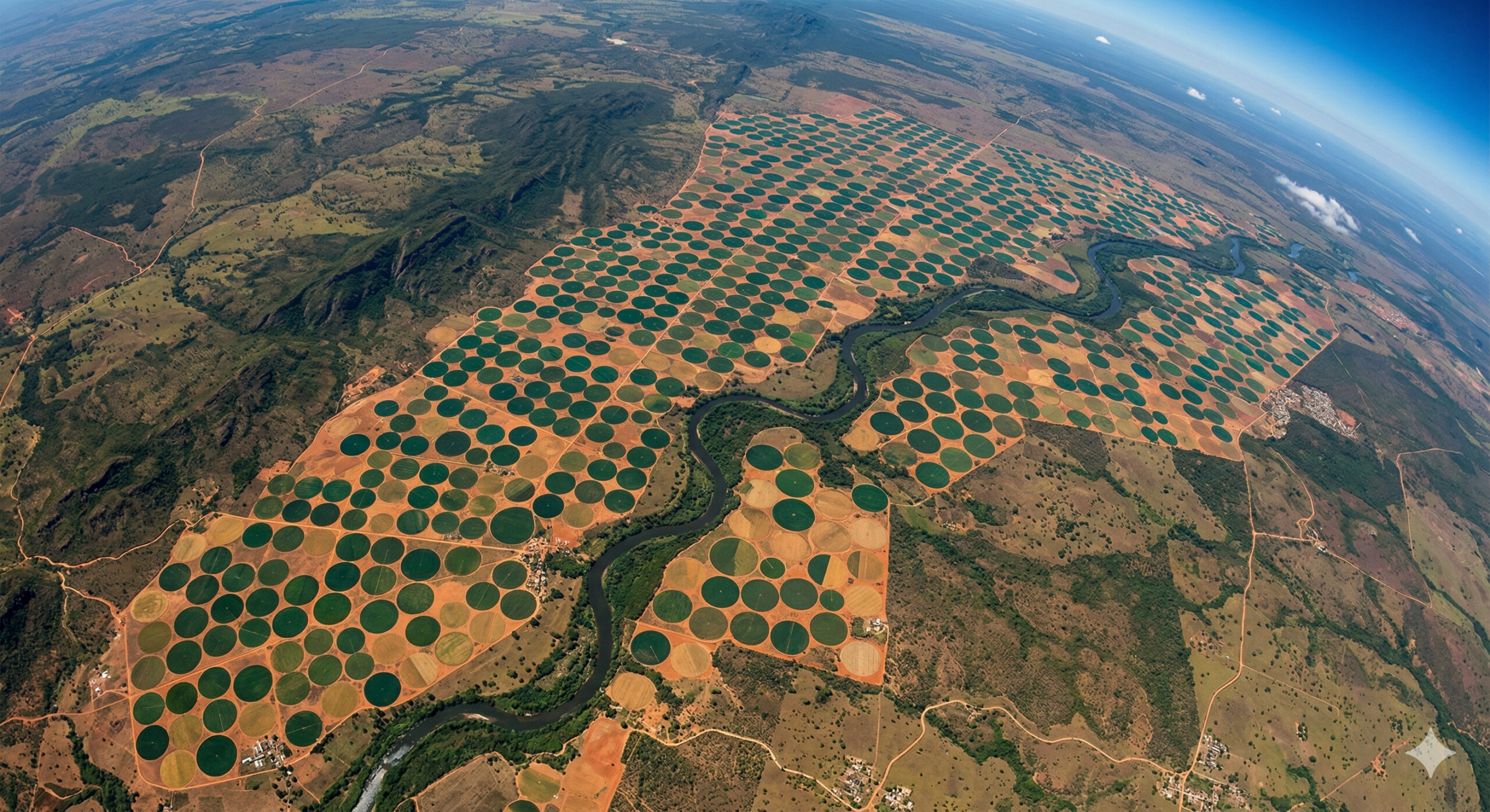
Gigantic irrigation circles in Bahia are visible from space and reveal agricultural technology that transforms crops into perfect geometric patterns.
Images released by NASA through the Earth Observatory revealed a phenomenon that impresses both by its scale and precision: in the interior of the state of Bahia, agricultural areas appear from space as gigantic nearly perfect circles, drawn across the natural landscape. Captured by satellites in Earth orbit, these images show geometric patterns so defined that they resemble targets or giant mandalas, visible from hundreds of kilometers in altitude.
According to analyses published on the official NASA Earth Observatory portal, these circles are not natural formations, but a direct result of modern agricultural technology based on center-pivot irrigation systems, widely used to optimize water use and increase productivity on a large scale.
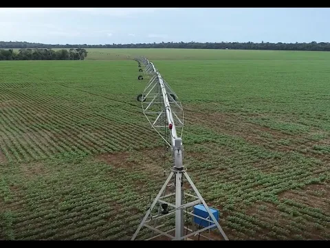
Center pivot irrigation systems create visible patterns from orbit
These circular shapes are produced by a system known as center pivot irrigation, one of the most widely used technologies in modern agriculture.
-
15-Year-Old American Builds Ocean Generator with PVC Pipe and 3D-Printed Propeller for $12, Wins National Prize, Presents at White House, and Makes Forbes 30 Under 30 List

-
$12 Billion Invested in AI Data Centers in Semi-Desert Mexican State, But 17 of 18 Municipalities Now Face Water Shortages, Residents Receive Water Only 3 Days a Week
-
How Much Does Starlink Satellite Internet Cost for Cars, Trucks, and RVs? Prices for Antenna, Accessories, and Plans

-
Scientists Convert Food Waste into Aviation Fuel, Successfully Test 50% Blend with Conventional Kerosene to Cut Emissions and Promote Sustainable Flights


The operation is relatively simple, but extremely efficient: a metal structure rotates around a fixed central point, distributing water evenly along a radius that can exceed 500 meters, creating circles that can cover dozens of hectares.

Each complete rotation of the equipment irrigates the entire cultivated area, resulting in a perfectly circular pattern when viewed from above.
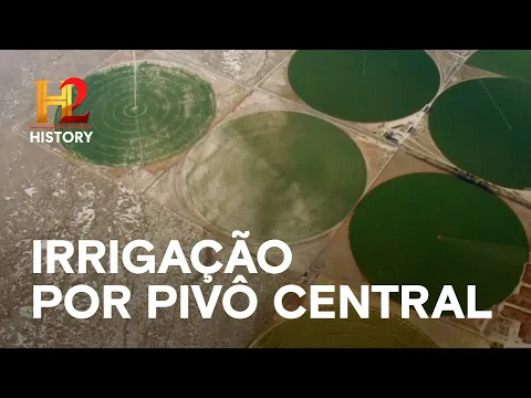
This type of irrigation is widely used in regions with drier climates or irregular rainfall, such as parts of inland Bahia, where efficient water management is essential.
Contrast between irrigated vegetation and dry soil makes the circles visible
What makes these circles so visible from space is not just their shape, but the contrast they create with the surrounding environment.
Within the irrigated areas, the vegetation shows a more intense and uniform coloration, indicating greater availability of water and nutrients. Outside these areas, the soil tends to be drier, with less dense vegetation.
This contrast creates a striking visual difference, transforming crops into clearly defined geometric figures, easily identifiable in orbital images.
In many cases, different crops or growth stages within the circles also generate color variations, further enhancing the visual effect.
Precision agriculture transforms natural landscapes into geometric patterns
The presence of these circles in the interior of Bahia is a direct reflection of what is called precision agriculture, which uses technology to optimize resources and maximize productivity.
Sensors, monitoring systems, and agricultural planning allow each area to be irrigated in a controlled manner, reducing waste and increasing efficiency.
The result is a complete transformation of the landscape, where natural or semi-arid areas begin to exhibit highly organized geometric patterns.
This type of agriculture is common in grain, cotton, and other large-scale crop-producing regions, which require strict control of water and nutrients.
Orbital images are used to monitor large-scale agricultural production
In addition to the visual impact, these images have great scientific and economic importance.
Satellites used by space agencies allow monitoring:
- Expansion of agricultural areas
- Irrigation levels
- Health of crops
- Land use

This information is essential for agricultural planning, water resource management, and productivity analysis. In the case of Bahia, the images help track the advancement of agriculture in regions that historically had lower production, highlighting changes in land use over time.
The scale of the circles impresses and can be perceived hundreds of kilometers away
The circles formed by center pivots are not small. In many cases, each area can have hundreds of meters in radius, covering areas equivalent to dozens of football fields.
When several systems are installed close to each other, the result is a landscape composed of dozens or even hundreds of interconnected circles.
This scale is what allows them to be seen from space, even from hundreds of kilometers in altitude.
In global images, these patterns appear as clear artificial marks on the Earth’s surface, standing out amidst the natural vegetation.
Agricultural technology redefines the appearance of the planet seen from space
Just as illuminated cities transform the Earth’s night into a mosaic of light, modern agriculture alters the appearance of the planet during the day.
Highly mechanized agricultural regions begin to display geometric patterns that do not exist in nature, creating a new visual aesthetic of the Earth.
The irrigation circles are one of the most evident examples of this transformation, showing how human activity can completely reorganize natural space.
Bahia stands out as an example of agricultural expansion with technology
The interior of Bahia, especially regions like the western part of the state, has established itself as an important agricultural frontier in Brazil.
The adoption of technologies such as center pivot has allowed for increased production even in areas with water limitations.
This technological advancement is one of the factors explaining the growth of agricultural production in the region, making it increasingly relevant on the national stage.
Giant circles seen from space show how technology redraws the surface of the Earth
The images of the irrigation circles in the interior of Bahia reveal more than just a curious visual phenomenon. They clearly show how modern agricultural technology is transforming the terrestrial landscape.
With perfect geometric patterns visible from space, these systems demonstrate the direct impact of human action on the organization of territory, creating shapes that can only be fully appreciated from hundreds of kilometers in altitude.
More than just crops, these circles represent the combination of engineering, science, and large-scale production, redefining how the planet is viewed from space.